In previous stories, I have relied upon the use of specific online programs or tools that map genetic genealogy with geography. Specifically, one of those heuristic tools I have utilized is the GlobetrekkerTM program that was created by FamilyTreeDNA to map the estmated migratory path of my YDNA ancestors to my most recent (as of the date of this story) ancestral haplogroup G-Y132505 – recognized by various genetic genealogical organziations. ( see video below).
Just to ensure we are speaking with understood terms, a haplogroup is a genetic grouping of people who share a common ancestor, identified by specific DNA markers (mutations) in the non-recombining parts of our DNA. In this context the YDNA for paternal lineage, tracing ancestral migration and origins. These markers act like unique signatures, showing branches on the human family tree and revealing deep ancestral paths across time and continents. [1]
Illustration One: Globetrekker Video of the Migratory Path for YDNA ancestors of the Most Recent Common Ancestor of Haplogroup G-Y132505
Source:The migration route to of YDNA haplogroups to most recent ancester of haplogroup G-Y132505, Globetrekker, FamilyTreeDNA, Accessed 16 Jan 2026
To provide historical context and complimentary information to the Globetrekker animated YDNA migratory path in illustration one, I have also utilized the results of archaeological research by a group of archaeologists that employ a mutlidisciplinary approach to identify and explain the persistence of travel corridors in one portion of this migratory path: the Late Roman era and the ‘dark ages’ of the early medieval era.
The Globetrekker program provides a specific outline of my patrilineal migration path, while landscape archaeological studies document historically persistent places, and movement corridors that supply the fine‑grained, time‑specific spatial frameworks needed to interpret those migratory paths in real historical landscapes. Used together, they let you move from an abstract geographical Y‑DNA trajectory to concrete hypotheses about which river valleys, trackways, settlement hubs, and settlement zones specific YDNA lineages likely used or avoided in particular periods. For those that think in graphical terms, I offer a venn diagram in illustration two below.
Illustration Two: The Methodological Overlapp between the Use of Globetrekker and Landscape Archaeological Research
The focus of this story is discussing, in greater detail, the utility and integrative nature of using Globetrekker, the genetic genealogical mapping tool, with the research findings associated with landscape archaelogy when weaving family stories about YDNA migration in the ‘dark ages’ in an area we now call the Netherlands. Using this phylogeographical tool and the unique blend of landscape archaeological research has given me an appreciation of what roughly 95 or so generations of my YDNA lineage experienced in their migration in the late Roman and Early mediaval eras.
What is GlobetrekkerTM
The mix of genes and geography is the most potent recipe for studying human history. Phylogeography has attempted that feat since the 1980s, and we are taking it one step further with Globetrekker! How did your ancestors trek across the globe?[2]
Phylogeography is the study of how genealogical lineages are distributed across geographic space through time, using genetic data to infer the historical processes that generate patterns of variation. It explicitly links phylogenetics and population genetics with biogeography, focusing on how climatic or geological change structure genetic lineages within and among closely related populations and species. [3]
Table One: Breakdown of What is Phylogeography
Phylogenetics
The study of evolutionary relationships between organisms, aiming to reconstruct their shared ancestry and evolutionary history, primarily using DNA/RNA sequences [4] or physical traits. [5]
Population Genetics
The study of genetic variation within and between populations, focusing on how allele frequencies (a variant of a gene) change over time due to forces like natural selection, genetic drift, mutation, and migration. [6]
Biogeography
The scientific study of how and why plants, animals, and ecosystems are distributed across Earth’s surface. [7]
Modern statistical phylogeography usually considers genome-wide (population) spread, whereas the Globetrekker platform utilizes the test results of Big Y DNA customers, solely for exploring patrilineal history.
Globetrekker is a specialized mapping tool originally developed by FamilyTreeDNA (FTDNA) as an exclusive feature for their Big Y-DNA test customers. It visualizes ancestral migration paths on a global scale, tracing paternal lineage journeys from “Y-Adam” (the earliest common paternal ancestor, approximately 200,000 years ago) to the most recent known locations of direct paternal ancestors. [8]
Globetrekker employs ‘advanced phylogenetic algorithms’ that factor in geographical topography, historical sea levels, land elevations, and ice age glaciation patterns to determine likely ancestral migration routes. The tool also incorporates user-provided information regarding the earliest known ancestors (EKAs) to pinpoint the migratory patterns. [9]
The developers of Globetrekker specifically adapted the use of least cost paths (LCPs) and least cost corridors (LCCs) as probabilistic migration zones, including a tiered 95, 96.6 and 98.3 percent corridor scheme from landscape genetics research. The method takes the inferred locations of successive haplogroups and connects them with LCPs, computed over a ‘cost surface’ built from slope, distance to land, coastal routing, sea currents, and glacial boundaries. Around each LCP, it builds LCCs that represent areas that are 95%, 96.6%, and 98.3% likely to contain the ‘true’ path.
Corridor paths are derived from LCP and LCC modeling, adapted from landscape genetics methods published in Heredity, the official journal of the Genetics Society. The algorithm uses environmental data and ancient geography to estimate ancestral movement across time. [10]
Earlier phylogeography tools largely used ‘centroids’ (a geometric center, or “balance point,” representing the average position of all its points of tester locations and straight or smoothed “as‑the‑crow‑flies” lines between them). Globetrekker instead uses a cost-based movement model from landscape genetics to reflect realistic movement constraints. The explicitly probabilistic corridor bands (rather than a single deterministic line) are the key innovation taken from landscape genetics, providing confidence-style envelopes around each inferred migration segment instead of just mapping one route.
GlobeTrekker identifies each ancestral haplogroup’s probable position and then connects them using these ‘cost-efficient routes’ that consider:
Slope steepness (to avoid rugged terrain);
Distance to land (favoring coastlines);
Ocean current direction and strength (penalizing movement against currents); and
Past topography and sea levels, including exposed Ice Age land bridges and glacial boundaries. [11]
In a FamilyTreeDNA blog article, Paul Maier, a population geneticist for FamilyTreeDNA argues that combining phylogenetic structure, curated environmental reconstructions, least‑cost path/corridor methods from landscape genetics, and time‑aware spacing between haplogroups transforms Globetrekker from a simple “dot map” into a probabilistic reconstruction of human movement constrained by both genetics and landscape. [12]
Paul Maier
Click for Larger View | Source: Maier, Paul, Part 2: Advancing the Science of Phylogeography, 15 Aug 2023, FamilyTreeDNA Blog, https://blog.familytreedna.com/globetrekker-analysis/
Maier emphasizes that the Globetrekker outputs are still model‑based estimates. The least‑cost paths and the three‑tier least‑cost corridors provide a graded ‘confidence envelope’. They rely on simplified assumptions about what constituted “cost” for past humans and may need future tweaking as scholarship on mobility improves. He concludes that Globetrekker currently represents the latest advance in Y‑DNA research at FTDNA by integrating their Big Y age estimates (their most comprehensive YDNA test) [13] , Discover™ ancient DNA reports (unique YDNA summary reports) [14] , and landscape genetics.
He anticipates iterative refinement as more samples, better environmental data, and improved ideas about human movement become available. A key operational takeaway is that the accuracy of Globetrekker depends heavily on users supplying correct, internally consistent Earliest Known Ancestor (EKA) countries and coordinates. These EKAs represent ‘leaf‑level’ new haplogroup branches, anchors of the haplogroup tree, that drive the entire bottom‑up placement of ancestral nodes.
Maier describes a four‑step workflow. In laymen’s terms, what this four step workflow entails is (1) build the old world map your ancestors actually faced, (2) clean the data so only believable, consistent locations remain, (3) estimate where each ancestor probably lived on that changing map, and (4) draw the easiest likely routes between those places using “path of least resistance” rules. [15]
The method first reconstructs past coastlines, land bridges, ice sheets, and ocean conditions so that migrations are modeled on the world as it looked thousands of years ago, not today. It also distinguishes between overland, coastal, and open‑ocean travel, favoring routes that hug coasts or land when that fits known historical patterns.
The second stage involves cleaning up the data. The samples of YDNA that obviously do not fit history (for example, a European Y‑line placed in colonial‑era America) or whose coordinates contradict the reported country are removed or corrected. YDNA branches where the few samples are scattered across continents, or where a single odd sample would distort the pattern, are collapsed so outliers do not drag the inferred migration unrealistically.
In the third stage, the method works up the phylogenetic tree, starting from known Y700 test results of YDNA users’ EKA locations and documented ancient samples, then placing each ancestral common ancestor asociated with haplogroup branches roughly in the middle of its closest descendant branches, while giving more weight to better and nearer‑in‑time data. It then adjusts these positions so they stay on plausible land at the right time, smooths away zig‑zags caused by outliers, and spaces ancestors according to their genetic ages so older ancestors are not forced to sit right next to modern descendants.
Once ancestral points are set, in the fourth stage the software connects them with “least‑cost paths,” which are the easiest routes given terrain steepness, distance from land for coastal travel, and ocean currents for sea travel. Around each path it builds “corridors” showing broader zones that are still quite likely, giving a visual band of plausible movement rather than a single razor‑thin line.
Whew, easier said than done.
The Lowlands in the Dark Ages in ‘an Interdisciplinary Light’
This subheading in this story is derived from a published study by Esther Jansma and associates entitled, “The Dark Age of the Lowlands in an interdisciplinary light: people, landscape and climate in The Netherlands between AD 300 and 1000“.
I thought it was an eye catching title for an interesting but perhaps dense research paper that I thought was an amazing article. It is a catchy literary or rhetorical use of placing contrasting elements (“dark ages” and “in an interdisciplinary light”) in close proximity to highlight their differences and to create an interesting effect. “Dark Ages” is a discriptive term that has been used to describe an historical era that we lack of knowledge of. “Interdisciplinary light” is a metaphor for knowledge, understanding, or illumination across academic disciplines. [16]
The title implies that the research “illuminates” a period previously considered “dark” or poorly documented. The research reported in the paper does indeed provide an innovative scientific and historical approach to shed light on human interaction with the environment, in the area we call the Netherlands in the early Medieval era. The research is part and reflective of a larger innovative interdisciplinary research effort that focused on the ‘dark ages’ in the lowlands. The research from this project and from scholars using related interdisciplinary approaches have increased my understanding of historical facts and my ability to document and make sense of my research on the migratory path of the Griff(is)(es)(ith) YDNA genetic lineage in this time period.
The “Dark Ages” is a misleading label for a complex era of upheaval and transformation, not just a mysterious era as implied by the name. The “Dark Ages” typically refers to Europe’s Early Middle Ages, roughly 476 CE to 1000 CE. It is a time perod where not much is available in written form. It is a period following the fall of Rome marked by societal decline, warfare, and fragmentation.
However, the dark ages is now seen by historians as an oversimplification, as this era also saw the rise of christian monasticism, significant cultural growth, agricultural innovations, and the emergence of foundations of later medieval society. The term itself originated from Renaissance scholars who contrasted it unfavorably with antiquity. [17]
During roughly 400–800, the Netherlands region shifted from a Roman frontier zone with towns, taxation and a military‐fiscal economy to a patchwork of largely rural, low-density agrarian societies under shifting Frankish and Frisian political control, with new elites, emerging Christian institutions, and long-distance trade hubs like Dorestad emerging by the late seventh to eighth centuries. Rather than a uniform “dark age,” it was a period of demographic contraction and reoccupation, environmental stress and adaptation, and gradual consolidation of Merovingian and then Carolingian social structures of lordship and ecclesiastical power. [18]
As discussed in a mult-part story, a genetic YDNA ancestor of the Griff(is)(es)(ith) line lived at the end of the Roman era or perhaps the late iron age / early medieval times, the ‘dark ages’, in an area that is now known as the Netherlands. This ancestor was the most recent common ancestor of the haplogroup G-Z6748. He was born approximately 668 CE.
The dark ages coincided with dramatic land-use changes in many parts of post-Roman Europe. [19] This collapse coincided with a period of severe river-network changes due to increased sedimentation and flooding in the Meuse Rhine River watershed area. [20] During the Dark Ages in the Netherlands, coastal areas faced intense environmental change from human-induced peatland drainage (causing land subsidence and increased flooding) and natural sea-level rise, transforming peat bogs into tidal zones and salt marshes, leading to widespread inundation, drowned settlements, and a shift towards a more maritime landscape. [21]
Severe depopulation also took place and trade networks collapsed. Various aspects of the previous Iron-Age cultural landscape re-emerged. Researchers utilizing this multidisciplinary approach highlight the value of integrating archaeological, geoscientific, and modeling approaches to test hypotheses about past population dynamics and their consequences for historical landscapes. [22] As identified by van Lanen and Groenewoudt, several sub‑regions experienced the late/post‑Roman decline with markedly different timing and severity, especially when comparing the coastal belt, the central river area, and the higher coversand zones inland. [23]
The Dark Ages (Early Middle Ages) in the Netherlands, marked by Roman collapse and decliining population shifts, created a foundation for the remaining population base to create a growing structure of stable local male lineages due to the persistence of patrilocal groups and limited geographical male movement, leading to strong regional YDNA structures. The Dark Ages established the basis for distinct male lineages in the Netherlands, but it was later medieval and early modern processes that fully developed the complex regional YDNA patterns that we see today. [24]
The Research Program ‘Dark Ages in an Interdisciplinary Light‘
The research mentioned above by Esther Jansma and associates explore the Late Roman to Early Medieval period in the Netherlands by combining research methodologies from archaeology, dendrochronology (tree-ring dating), palaeoecology, geography, and climate science to understand human-landscape interaction. The research was the result of collaborative efforts by researchers from a number of different academic disciplines and part of a larger funded research project. This project integrates diverse archaeological datasets (e.g., wood analysis, pottery distribution, elevation models) to create an holistic understanding of the Dutch Lowlands, demonstrating how environmental factors, climate shifts, and human decisions shaped this historical era.
The work of Jansma and associates was part of a larger research program with a common theme. The research program, ‘The Dark Age of the Lowlands in an interdisciplinary light’, was funded by The Netherlands Organization for Scientific Research (NWO, 2012-2017) and managed at the department of Physical Geography at Utrecht University, Netherlands.
“The program focuses on spatial developments in the Low Countries during a period of severe pan-European economic and demographic change: the Late Roman Period and the Early Middle Ages (AD 300- 1000). Physical-geographical and palaeoenvironmental data from coastal-deltaic lowlands and more inland regions in the Netherlands indicate marked landform and land-use changes as well as climatic variability during this time interval.” [25]
Illustration Three: Research Areas of the Interdisciplinary Program
Click for Larger View | Source: Modification of Figure One in Esther Jansma, with Marjolein Gouw-Bouman, Rowin Van Lanen, Harm Jan Pierik, Kim Mikkel Cohen, Bert J. Groenewoudt, Wim Hoek, Esther Stouthamer, Hans Middlekoop, The Dark Age of the Lowlands in an interdisciplinary light: people, landscape and climate in The Netherlands between AD 300 and 1000, european Jourrnal of Postclassicalarchaelogigies (4) May 2014, 471-476
The project received core project funding for roughly six to seven years. NWO lists the project within the 2012–2019 window. The 2012–2017 bracket mentioned in Jansma et. al’s. paper captures the main funding phase. It directly generated at least eight peer ‑ reviewed scientific articles, four substantial book‑chapter–type product contributions listed by NWO, and underpinned at least three PhD projects (although these theses are not enumerated individually on the public NWO and Utrecht portals). [26]
What Defines this Mutlidisciplinary Approach in Studying the Dark Ages in the Lowlands?
These studies involve overlapping research traditions. They are often framed explicitly as contributions to a broader “landscape‑archaeological” and “connectivity/persistence” program for the Dutch delta in the first millennium CE.
Researchers such as Van Lanen, Groenewoudt, Spek and Jansma, among others, work firmly within landscape archaeology, combining palaeogeography, geomorphology, soils and hydrology with archaeological data to reconstruct “total” cultural landscapes through time.
“Landscape archaeology can be defined as the interdisciplinary investigation of the long-term relationship between people and their environment . . . . Probably the greatest benefit of a landscape-archaeological approach is the way it shifts the focus from a “single-site” perspective to much larger areas that are more closely matched to the physical scale at which human societies operate. Such an approach is inevitably multidisciplinary. Landscape-archaeological approaches have in common that the (dynamics of) the historical landscape as a whole is being investigated as a single, complex “site.” “Landscape” within this context is defined at a basic level, being “an area, as perceived by people, whose character is the result of the action and interaction of natural and/or human factors”.” [27]
Methodologically this aligns with a wider international trend in settlement and landscape archaeology that uses Geographic Inforation Systems (GIS) based modelling [28] to study accessibility, route networks and off‑site activity areas, but the Dutch work is unusually systematic in its national-scale application and depth. This places their studies within a wider school of archaeological research on long‑term network stability and path dependence in cultural landscapes, but with a strong Dutch delta variant that treats route networks, settlements, demography and land use as dynamically interacting subsystems.
Their publications explicitly frame “connectivity” (degree of interlinkage between places) and “persistence” (long‑term re‑use of locations and corridors) as key analytical concepts, drawing on Sarah Schlanger’s notion of “persistent places” and embedding them in what is referred to as a ‘multi‑proxy modelling framework‘.
Sarah Schlanger used “persistent place” to describe locations that are repeatedly used over the long-term occupation of a region, and that link isolated finds with more substantial archaeological sites in a single landscape-use system. Schlanger defines persistent places as localities “that were repeatedly used during long-term occupations of regions,” neither reducible to formal archaeological sites nor to passive landscape features but emerging from the conjunction of particular behaviors with particular locations. [29]
“I propose to treat both the isolated (archaeological) finds and the sites together and to employ them as tools for studying the use of a landscape occupied by prehistoric horticulturalists. The concept I use to link sites and isolated finds to landscapes is the concept of the “persistent place,” a place that is used repeatedly during the long-term occupation of a region.” [30]
Persistent places may be associated with:
Unique environmental or topographic qualities that attract recurrent use (e.g. marsh edges, access routes, vantage points);
Cultural constructions such as hearths, shelters, storage features, or house ruins that focus and structure later reoccupation.; and/ or
Accumulations produced by repeated visits and use that are not dependent on built features but on the continued presence of cultural material in the landscape.
These places are archaeologically visible as spots where occupations, activities, and material deposition recur over extended periods to tme, producing multicomponent assemblages or dense accumulations within a wider settlement system. Schlanger also emphasizes that entire landscapes can function as persistent places when patterns of reoccupation, abandonment, and return maintain enduring relationships between people and particular tracts of land across centuries.
A multi-proxy modeling framework integrates diverse, indirect natural records (proxies like tree rings, ice cores, sediments) to reconstruct past environments, using statistical or computational models to combine their complementary ‘signals’, quantify uncertainties, and gain a more robust understanding of past climate or other conditions than any single proxy could provide alone. This framework moves beyond simple cross-checking, using advanced techniques to blend data, model uncertainties consistently, and reveal complex climate histories.
A well-known example is the multi‑proxy route‑modelling framework developed by Van Lanen and colleagues for reconstructing Roman and early medieval transport networks in the Netherlands. Van Lanen et al. combine several data types in a single GIS‑based modelling framework. The framework integrates environmental friction surfaces (soil, relief, hydrology), archaeological settlement and burial distributions, and shipping‑related finds to generate and validate route networks for different time slices (e.g. 100, 500, 900 CE). [31]
These researchers utilize a research approach that integrates layers of archaeological settlement data, geomorphological maps, soil and groundwater data and tree ring data within Geographic Information Systems (GIS) models, to understand the long-distance transport routes and their dynamics during the first millennium CE in the Dutch river delta (see illustration four).
Illustration Four: An Example of a Flowchart of route-persistence calculationsbased on integrating various historical data sets
Click for Larger view | Source: Figure 3 in Rowin J. van Lanen, Bert J. Groenewoudt, Theo Spek & Esther Jansma, Route persistence. Modelling and quantifying historical route-network stability from the Roman period to early-modern times (AD 100–1600): a case study from the Netherlands, Archaeol Anthropol Sci (2018) 10:1037–1052
This interdisciplinary approach produces predictive models to reconstruct past movement corridors and assess their persistence through time. Route persistence is studied to explain long‑term settlement foci, land‑use patterns, and “persistent places” in cultural landscapes.
How the Methodological Approaches Associated with Globetrekker and Landscape Archaeology Compliment Each Other
Globetrekker provides a statistically smoothed, large‑scale reconstruction of patrilineal migration paths, while landscape‑archaeological work on connectivity, persistence places, and corridors can supply the fine‑grained, time‑specific spatial frameworks needed to interpret those paths in real historical landscapes. Used together, they let you move from an abstract Y‑DNA trajectory to concrete hypotheses about which river valleys, trackways, hubs, and settlement zones specific lineages likely used or avoided in particular periods.
Landscape‑archaeological models reconstruct route networks and “hypothetical movement corridors” from palaeogeography, soils, elevation, groundwater and other geoscientific data, then test them against settlements, burials, shipwrecks, etc. Persistence analysis identifies long‑term stable “persistent areas” and route segments that remain in use across multiple time periods, often clustering around later historic towns and acting as long‑term attractors for movement and settlement.
Globetrekker’s broad phylogeographic path can be overlaid onto modeled corridor networks to see which persistent corridors and hubs are most compatible with a given haplogroup’s inferred movements in each time slice. Conversely, where corridor models predict strong, long‑lived route networks but relevant haplogroups show limited crossing, that mismatch can highlight demographic boundaries, cultural frontiers, or asymmetric connectivity not obvious from archaeology alone.
From Generic Paths to Specific Corridors
Corridor models can ‘dissect’ Globetrekker’s smoothed line into concrete options for consideration. For example, the findings of land archaeological studies can help determine whether a patrilineal trajectory into a basin is more consistent with a specific river system, interfluve ridgeway, or coastal lowland, given friction surfaces and known route persistence. This allows for the targeted assessment of archaeological fndings once a Globetrekker path intersects a persistence zone. One can focus on settlements, cemeteries, and land‑use systems in that zone to see whether demographic signals align with the Y‑DNA branch’s age and geography.
Integrating Time, Scale, and Uncertainty
Landscape models operate in ‘temporal windows’ (e.g. Roman, early medieval, early modern) with explicit environmental boundary conditions, while Globetrekker provides genetic based ‘temporal anchors’ for each branch. Aligning the two tightens chronological hypotheses for when specific corridors became important for a migration. Because Globetrekker includes spatial “hotspots” and uncertainty bands, overlapping those with areas of modeled ‘accessibility’ and ‘long‑term route persistence’ helps distinguish our historically informed inferences from speculative ones, improving how genealogical users read the maps.
A Comparison of the Terms Used by Globetrekker and Landscape Archaeology
Globetrekker and Roman/early‑medieval route‑persistence studies use overlapping but differently framed vocabularies for movement and connectivity; many terms map cleanly onto each other if treated as probabilistic models of paths and corridors through constraining landscapes.
The table below pairs key terms and highlights how each field conceptualizes routes, uncertainty, and long‑term stability.
Table Two: Comparison of Similar Terminology
Concept focus
Globetrekker term
Route‑persistence / land‑archaeology term
Basic movement line
Migration path / ancestral path: LCP‑based line connecting ancestral haplogroup locations over time. [32]
Route / path / road segment: modeled or attested line of movement between nodes (settlements, crossings). [33]
Probabilistic zone
Least Cost Corridor (LCC) with 95–98.3% “corridor levels” expressing likelihood the true path lies within. [34]
Route zone / movement corridor: network friction derived bands of high accessibility predicting likely route orientations. [35]
Movement cost surface
Friction layers from slope, distance to land, currents, land/sea masks used to compute LCPs between haplogroup points. [36]
Network‑friction surface / cost surface combining palaeogeography, soils, elevation, groundwater, etc., to model accessibility. [37]
Spatial uncertainty
Hotspot: spatial uncertainty envelope around a haplogroup’s “Mean Path Intersect” location. [38]
Uncertainty band / model error: spatial tolerance where modeled route zones are checked against observed infrastructure/ finds. [39]
Temporal anchors
TMRCA‑based time slices and animated migration through chronologically ordered haplogroup nodes. [40]
Periodized networks (Roman, early‑medieval, early‑modern) compared across time windows to study change and continuity. [41]
Multi‑period stability
(Not a formal label, but visually implied) overlapping paths for many lineages through similar corridors over time. [42]
Route persistence / route‑network stability: quantified degree to which route‑zone sections recur across periods (e.g. AD 100–1600). [43]
Preferred options
Most likely corridor / most likely path determined by combined LCP + corridor modeling and filtering. [44]
Best travel options: multi‑proxy modeled Roman and early‑medieval routes that maximize accessibility and match archaeological evidence.[45]
Spatial nodes
Implicit ancestral location nodes where haplogroups are time‑stamped and paths turn or branch. [46]
Nodes / hubs / crossings / persistent places: intersections of major routes, river crossings, and long‑lived focal points of movement. [47]
Model validation
Internal checks on Earliest Known Ancestor (EKA) consistency, comparison with ancient DNA points and geography; corridors treated as confidence envelopes. [48]
Validation with infrastructure and finds: percent of known Roman/ early ‑ medieval roads and isolated finds falling inside modeled route zones. [49]
Globetrekker’s vocabulary centers on phylogeographic inference and statistical confidence (the most recent common ancestor [TMRCA], hotspots, LCP/LCC corridors, likelihood levels) because its primary goal is to model lineage trajectories from genetic data under environmental constraints.
Roman/early‑medieval route‑persistence work focuses on accessibility, stability, and ‘multi‑proxy’ validation (network friction, route zones, persistence, best travel options) because it aims to reconstruct and quantify real route networks across periods using environmental data plus archaeological observations.
The Ability to Understand the Longue Durée of Genetic Migration through the Landscape Archaeological View
Similar to the advantages of combining traditional genealogical research with genetic genealogy to understand different time perods of genealogical research, the ablity to combine the results from the Globetrekker tool with landscape oriented archaeology greatly enhances our ability to understand the ‘Longue Durée” period of our genetic genalolgy. [50]
Landscape archaeological approaches developed for the “Dark Age” / first millennium AD in the Netherlands have been applied to other regions and to many different periods, from the Palaeolithic to the High Middle Ages and beyond. For example, in the Southern Baltic lowlands, high‑resolution reconstructions of how a major medieval trade route (via Marchionis) shaped erosion, vegetation and agrarian regimes over centuries, combining cores, pollen and archaeological data. [51] Also. in the early medieval Wessex (England) area, Langlands’ work models road networks and communications using charter boundary clauses, toponymy, topography and archaeological evidence, explicitly framed as a landscape approach to routes and movement. [52] These are methodologically very close to the Dutch “Dark Age” connectivity and persistence studies, just in different historical and documentary contexts.
Within the Netherlands the same approach has been pushed both backwards and forwards in time. Fokkens and his successors’ work on a “living landscape” in the Neolithic Iron Age uses large datasets of settlements, burials and deposits to reconstruct Bronze and Iron Age cultural landscapes at multiple scales. [53] Historical land‑use research in Drenthe and other sandy upolands links prehistoric barrows, Celtic fields, medieval fields and later agrarian systems into a single diachronic landscape narrative. [54] Vos and others trace reclamation, peat ingressions and flooding in late Iron Age – Medieval wetlands from the Late Iron Age through ca. 1000 CE, explicitly as coupled physical and social landscape change. [55] So the “Dark Age” program is one phase within a much longer Dutch landscape‑archaeological tradition.
Beyond the Low Countries and early medieval Europe, landscape archaeology has been adapted to different time periods. For example, palaeolithic work on the Middle Palaeolithic in the Netherlands situates Neanderthal sites within loess plateaus, ice‑pushed ridges and glacial geomorphology, treating the landscape template as central aspect to interpreting the past. [56] Another example is a study of medieval road operation in the southern Baltic and other regions tieing route maintenance, erosion and vegetation to changing economic and political regimes at landscape scale. [57] There are also methodological overviews that explicitly present landscape‑factor case studies as templates or inspirations for other archaeological projects, underlining that the approach is not period‑bound. [58]
In practice, the same toolbox—palaeoenvironmental reconstruction, spatial modelling, settlement pattern analysis, and route/mobility modelling—is now used from deep prehistory to the late medieval period and in many different regions; what changes are the temporal resolution, available proxies and the historical questions being posed.
Sources:
Feature image: The story banner consists of a number of ‘Network-friction maps’, characteristic of the ‘Landscape Archaeological approach’, from left to right: (1) Areas in the Netherlands where landscape changes occur between AD 100 and 800. (2) Network-friction map AD 800 for water: areas with almost no network friction (accessible regions) have been designated as suitable areas for potential water routes. (3) Network-friction map AD 800 for land: light gray depicts areas with almost no network friction (accessible regions), which must have been suitable for potential routes. Dark gray grid cells depict areas with landscape obstacles (inaccessible regions). (4) Maps four and five represent land and water routes in 100 AD and 800 AD
[4] DNA/RNA sequences are the specific order of nucleotide bases (A, T/U, C, G) that make up a DNA or RNA molecule, essentially the genetic alphabet that carries instructions for building and operating living organisms, with DNA sequencing determining this order for DNA and RNA sequencing for RNA, revealing gene activity and functions.
Alberts B, Johnson A, Lewis J, et al. Molecular Biology of the Cell. 4th edition. New York: Garland Science; 2002. From DNA to RNA. Available from: https://www.ncbi.nlm.nih.gov/books/NBK26887/
[13] The FTDNA Big Y‑700 (often just called “Y700”) is FamilyTreeDNA’s most comprehensive Y‑chromosome test for genetic males. It is designed to characterize a man’s paternal line using both Short Tandem Repeats (STRs)and high‑coverage Single Nucleotide Polymorphism (SNP) sequencing. It aims to identify a test taker’s most precise Y‑DNA haplogroup by sequencing a large, SNP‑rich region of the Y chromosome and identifying both known and novel SNPs.
It is optimized for deep paternal lineage reconstruction, building out branches of the Y‑chromosome phylogenetic tree and refining time to the most recent common ancestor (TMRCA) estimates between men on the same line. Next‑generation sequencing targets roughly 20–25 million Y chromosome base pairs in the phylogenetically useful regions of the Y chromosome, reporting hundreds to thousands of known Single Nucleotide Polymorphism (SNPs) plus previously unknown variants unique to the tester. It also includes the full Y‑111 Short Tandem Repeats (STRs) panel plus at least approxmately 589 additional STR markers, giving a total of 700 plus Y‑STRs, which improves resolution for more recent paternal relationships compared with traditional Y37/Y67/Y111 STR marker tests.
[14] FamilyTreeDNA Discover™ ancient DNA reports are curated summaries that link your tested haplogroups (Y-DNA or mtDNA) to sequenced ancient individuals from archaeological contexts and to modeled ancient populations, with estimated timeframes and shared ancestry depths. They are designed as interpretive tools for context and hypothesis-building, not as direct genealogical matches in the usual family-history sense.
Discover’s ancient reports take published ancient DNA datasets and map them onto FTDNA’s Y- and mtDNA haplotree and autosomal reference panels, so your results can be compared to ancient individuals or populations that share a haplogroup or autosomal profile with your test kit.
The system then provides age estimates on most recent common ancestors asoociated with haplogroups (TMRCA), geographic and cultural metadata, and short narrative summaries to place those ancient connections in historical context.
For Y-DNA, Discover links a test kit’s haplogroup (especially Big Y–derived subclades) to ancient male individuals carrying the same or ancestral Y-haplogroups, and places them on the Discover haplogroup maps and time tree. Individuals who manage test kits are provided information onhaplogroup age estimates, approximate formation times for branches, locations of ancient samples (often shown as icons on maps or trees), and sometimes short context paragraphs about key sites or cultural phases represented by those ancient men.
Bavel, Bas van, ‘The Emergence of a Regional Framework in the Early and High Middle Ages: Land and Occupation’, Manors and Markets: Economy and Society in the Low Countries 500-1600 (Oxford, 2010; online edn, Oxford Academic, 1 May 2010), https://doi.org/10.1093/acprof:oso/9780199278664.003.0002
Erkens, G., , Sediment dynamics in the Rhine catchment – Quantification of fluvial response to climate change and human impact, “Netherlands Geographical Studies”, 2009.
[21] Pierik HJ. Landscape changes and human–landscape interaction during the first millennium AD in the Netherlands. Netherlands Journal of Geosciences, Volume 100, e11. https://doi.org/10.1017/njg.2021.8
C. Wickman, C., Rethinking the structure of the early medieval economy, in J.R. Davis and M. McCormick (eds), The Long Morning of Medieval Europe, Burlington, Ashgate, 2008 , pp. 19-31.
Willemsen, Annemariekeet and Hanneke Kik(eds) Dorestad in an International Framework. New Research on Centres of Trade and Coinage in Carolingian Times, Proceedings of the First ‘Dorestad Congress’, Leiden: Brepols Publishers, 2010.
[24] Altena, E., Smeding, R., van der Gaag, K.J. et al. The Dutch Y-chromosomal landscape. Eur J Hum Genet28, 287–299 (2020). https://doi.org/10.1038/s41431-019-0496-0
Doesburg, J. et al. 2016, “Roman and early‑medieval long‑distance transport routes in north‑western Europe: Modelling frequent‑travel zones using a dendroarchaeological approach.” Journal of Archaeological Science: Reports 6, 120–137. DOI: 10.1016/j.jasrep.2016.01.01910.1016/j.jasrep.2016.01.019
Van Lanen, R.J. et al. 2015, “Finding a Way: Modeling Landscape Prerequisites for Roman and Early‑Medieval Routes in the Netherlands.” Geoarchaeology 30, 200–222. DOI: 10.1002/gea.2151010.1002/gea.21510
Cohen, K.M., H.J. Pierik & E. Stouthamer 2016, “A new GIS approach for reconstructing and mapping dynamic late Holocene coastal‑plain palaeogeography.” Netherlands Journal of Geosciences 95, 51–78. DOI: 10.1017/njg.2016.1010.1017/njg.2016.10
Jansma, E., H.J. Pierik & R.J. van Lanen 2017, “Travelling through a river delta: A landscape‑archaeological reconstruction of river development and long‑distance connections in the Netherlands during the first millennium AD.” Netherlands Journal of Geosciences 96, e3. DOI: 10.1017/njg.2017.910.1017/njg.2017.9
Dinter, M. et al. 2017, “Late Holocene lowland fluvial archives and geoarchaeology: Utrecht’s case study of Rhine river abandonment under Roman and Medieval settlement.” Geomorphology 295, 227–243. DOI: 10.1016/j.geomorph.2017.07.01910.1016/j.geomorph.2017.07.019
Groenewoudt, B.J. & R.J. van Lanen 2018, “Diverging decline. Reconstructing and validating (post‑)Roman population trends (AD 0–1000) in the Rhine–Meuse delta (the Netherlands).” Journal of Archaeological Science: Reports 20, 189–218. DOI: 10.1016/j.jasrep.2018.04.01010.1016/j.jasrep.2018.04.010
Book / volume contributions
These chapter‑type items do not all carry DOIs; the most stable references are to the publisher or widely archived PDFs.
Jansma, E. et al. 2015, “The dendrochronology of Dorestad: placing early‑medieval structural timbers in a wider geographical context.” In: [Second Dorestad Congress volume], Turnhout (Brepols). Stable publisher series entry (Brepols “Dorestad” volume; no DOI given in catalogues).
Jansma, E. et al. 2016, “The dendrochronology of Dorestad: placing early‑medieval structural timbers in a wider geographical context – New research into early‑medieval communities and identities.” In: New Research into Early‑Medieval Communities and Identities, Turnhout (Brepols). No DOI listed; use series/publisher catalogue record as stable reference.
Kosian, M.C. et al. 2016, “Dorestad’s rise and fall: how the local landscape influenced the growth, prosperity and disappearance of an early‑medieval emporium.” In: [Dorestad‑related volume], Turnhout (Brepols). No DOI listed; use Brepols volume record.
Van Lanen, R.J. et al. 2019, “Counting heads: Post‑Roman population decline in the Rhine–Meuse delta (the Netherlands) and the need for more evidence‑based reconstructions.” In: Ruralia XII, Leiden (Sidestone Press). Stable link: https://www.sidestone.com/books/ruralia-xii
Other scientific outputs
Nooren, C.A.M. et al. 2018, “Is the onset of the 6th century ‘dark age’ in Maya history related to explosive volcanism?” Quaternary Science Reviews 186, 1–12. DOI: 10.1016/j.quascirev.2018.02.01710.1016/j.quascirev.2018.02.017
Riechelmann, D. et al. 2016, “Climate during the Roman and early‑medieval periods in North‑western Europe: a review of climate reconstructions from terrestrial archives.” Listed by NWO as conference review; an abstract rather than a full paper and no DOI is given in the project or author bibliographies.
Hoek, W.Z. et al. 2016, “Climate and environmental changes during the last 2000 years on Barentsøya and Edgeøya (E‑Svalbard).” Conference / project‑related output; no DOI recorded in UU publication lists, only meeting abstract reference.
Bilt, W. van der et al. 2016, “Short‑lived high‑amplitude cooling on Svalbard during the Dark Ages.” This work appears in palaeoclimate literature; the Quaternary Science Reviews article corresponding to this topic has DOI 10.1016/j.quascirev.2016.11.00110.1016/j.quascirev.2016.11.001, which is the stable identifier generally cited for this result.
Groenewoudt, B.J., R.J. van Lanen & H.J. Pierik 2019, “Bevolkingsaantallen berekenen – Kan dat, op basis van archeologische gegevens?” Popular‑scientific article (Dutch) without DOI; stable as print/HTML in the cited outlet only.
[28] GIS (Geographic Information System) is a computer-based system that captures, stores, analyzes, manages, and displays all forms of geographically referenced data, essentially linking location (where things are) with descriptive information (what they are like) to reveal patterns, relationships, and trends on maps
[50]Longue durée (French for “long duration”) is a historical concept, popularized by Fernand Braudel and the Annales School, that focuses on slow-moving, deep-rooted structures (like geography, climate, societies, cultures) rather than fleeting events, to understand historical change over vast stretches of time, emphasizing continuity and persistent patterns over centuries or millennia. It contrasts with “evental history” (histoire événementielle) by examining underlying long-term processes, like population growth, material civilization, or climate shifts, that shape human experience.
[51] Słowiński M, Brauer A, Guzowski P, Związek T, Obremska M, Theuerkauf M, Dietze E, Schwab M, Tjallingii R, Czaja R, Ott F, Błaszkiewicz M. The role of Medieval road operation on cultural landscape transformation. Sci Rep. 2021 Oct 22;11(1):20876. doi: 10.1038/s41598-021-00090-3. PMID: 34686702; PMCID: PMC8536699. https://pmc.ncbi.nlm.nih.gov/articles/PMC8536699/
Langlands, Alexander. The Ancient Ways of Wessex: Travel and Communication in an Early Medieval Landscape. Oxbow Books, 2019. JSTOR, https://doi.org/10.2307/j.ctv138wtbf
Vos, P.C., De Koning, J. & Van Eerden, R., 2015a. Landscape history of the Oer-IJ tidal system, Noord-Holland (The Netherlands). Netherlands, Journal of Geosciences/Geologie en Mijnbouw 94(4): 295–332
Vos, P.C. & Van Heeringen, R.M., 1997. Holocene geology and occupation history of the Province of Zeeland. Mededelingen Nederlands Instituut voor Toegepaste Geowetenschappen TNO 59: 5–109.
Vos, P.C., De Koning, J. & Van Eerden, R., 2015a. Landscape history of the Oer-IJ tidal system, Noord-Holland (The Netherlands). Netherlands Journal of Geosciences/Geologie en Mijnbouw 94(4): 295–332.
Vos, P.C., Van der Heijde, M. & Stuurman, E., 2015b. Landscape reconstruction of the Bronze Age site De Druppels found on a salt-marsh ridge of the Westfriese-inlet system; a casy study north of Alkmaar (Noord-Holland). In: Vos, P.C. (ed.): Origin of the Dutch coastal landscape: long-term landscape evolution of the Netherlands during the Holocene described and visualized in national, regional and local palaeogeographical map series. Barkhuis (Groningen): 294–319.
Vos, P.C, 2015. Origin of the Dutch coastal landscape: long-term landscape evolution of the Netherlands during the Holocene described and visualized in national, regional and local palaeogeographical map series. Barkhuis (Groningen).
Verstraeten, G., Broothaerts, N., Van Loo, M., Notebaert, B., D’Haen, K., Dusar, B. & de Brue, H., 2017. Variability in fluvial geomorphic response to anthropogenic disturbance. Geomorphology 294: 20–39.
Van Lanen, R.J., De Kleijn, M.T.M., Gouw-Bouman, M.T.I.J. & Pierik, H.J., 2018. Exploring Roman and early-medieval habitation of the Rhine-Meuse delta: modelling large-scale demographic changes and corresponding landuse impact. Netherlands Journal of Geosciences/Geologie en Mijnbouw 97(1–2): 45–68.
Słowiński M, Brauer A, Guzowski P, Związek T, Obremska M, Theuerkauf M, Dietze E, Schwab M, Tjallingii R, Czaja R, Ott F, Błaszkiewicz M. The role of Medieval road operation on cultural landscape transformation. Sci Rep. 2021 Oct 22;11(1):20876. doi: 10.1038/s41598-021-00090-3. PMID: 34686702; PMCID: PMC8536699. https://pmc.ncbi.nlm.nih.gov/articles/PMC8536699/
This is the eighth part of long story about a 2,850 year gap or absence of documented YDNA haplogroups in the Griff(is)(es)(ith) genetic YDNA paternal line. Various aspects of this gap have been discussed in the prior seven parts of the story. The gap started with the most common recent ancestor associated with haplogroup G-FGC7516 who was born around 2200 BCE. The next documented genetic ancestor in the Griff(is)(es)(ith) YDNA line is an ancestor associated with the G-Z6748 haplogroup. This gap of undocumented YDNA ancestors represents about 95 generations. It is a relatively big gap that spans a migratory path in a period of wide ranging changes in the environment as well as the social fabric of the landscape in northwestern Europe.
This part of the multi-part story (the eighth part) and the next part (the ninth and final part) focuses on a discussion about the ancestor associated with the G-Z6748 haplogroup and the undocumented generations that may have lived immediately before or after his life.
Specifically this part of the story focuses on the environmental influences and possible soecific migratory paths that might be associated with the generations on the tail end of this phylogenetic gap. The final, ninth part of the story focuses on the possible indigenous socio-cultural groups that might have been associated with these YDNA generations.
As discussed in part six of this story, the estimated possible migratory paths of the approximately 95 undocumented generations that are associated with this phylogenetic gap significantly widens as each successive generation approached and passed through the area that is presently known as the Rhine Meuse delta region. The eventual endpoint of this migratory path is where and when the ancestor associated with haplogroup G-Z6748 may have lived.
The possible migratory paths of the Griff(is)(es)(ith) YDNA genetic line were Influenced in varying degrees by the geographical and environmental influences impacting changes in the Rhine, Meuse, and other river watershed areas. As generations of the Griff(is)(es)(ith) YDNA lineage migrated northwestward through the lower Rhine and delta region, the marine activity on the north and west coastline and the changing terrain of the peat lowlands, increasingly played an influencing role on their migratory route.
In the late Roman and medieval periods, large parts of the western and northern Netherlands were covered by extensive peat bogs that changed over time. Research increasingly shows that major geographical changes (e.g., changing river courses, an increase of flooded areas and wet areas) occurred during the transition from the late-Roman (around 270 to 450 CE) to early-medieval periods (roughly 450 to 1050 CE). [1] Coinciding with these landscape changes, archaeological evidence in the modrn day Netherlands area points to a severe demographic decline as well as changes in settlement patterns and land use during this period. [2]
“The first millennium AD encompasses the Roman period (12 BC to AD 450) and the Early Middle Ages (AD 450 to 1050). In the Netherlands, this millennium saw population growth, steep decline and subsequent revival. In addition, many changes occurred in the physical landscape, marking a transition from a mainly natural prehistorical lowland landscape to an increasingly human-affected landscape.
“From the late 3rd century AD, . . . depopulation occurred, coinciding with the collapse of the Western Roman Empire and the large-scale migration of tribes throughout NW Europe. This period has traditionally been referred to as the ‘Dark Ages’ . This term on the one hand refers to a period of cultural decline and disorder, and on the other hand it is used for periods in general from which little information is available.“[3]
The Historical and Geographical Context of the Most Recent Common Ancestor (MRCA) of Haplogroup G-Z6748
As depicted in illustration one, it is estimated that the ancestor that marks the endpoint of this phylogenetic gap, a male descendant who represents the G-Z6748 haplogroup, was born around 668 CE. There is a 95 percent chance of certainty that he was born within a roughly six hundred year time span, 380 CE to 908 CE. There is a 68 percent chance that he was born between 524 CE and 792 CE, roughly a 275 year range (see illustration two). [4]
Illustration One: Scientific Details of the G-Z6748 Haplogroup
Harm Jan Pierik, a geographer who studies the geology and landscape evolution of the lowland areas, provides an informative illustration that situates two paleogeographical maps in a timeline based on five different time axes: general archaeological time periods, socio-cultural time periods, reforestation and deforestation cycles, climatic periods and geomorphological changes between 100 BCE and 1200 CE (see illustration two).
Illustration Two: Palaeogeographical maps of 100 CE and 800 CE of Netherlands
Click for larger View | Source: Fig. 2. Palaeogeographical maps of (A) AD 100 and (B) AD 800 in Pierik HJ. Landscape changes and human – landscape interaction during the first millennium AD in the Netherlands. Netherlands Journal of Geosciences, Volume 100, e11. https://doi.org/10.1017/njg.2021.8
This illustration provides a wealth of summary and graphic information on the Netherlands in the first millennium CE. The Dutch landscape shifted from mostly natural to an heavily human-altered environment. Changes, however, varied by region due to the nature of the local geography and people’s actions like farming, draining land, and cutting peat for building supplies and fire. Humans slowly weakened landscapes through everyday land use, until big events like storms tipped them into lasting new shapes—worst in peat coasts, milder in rivers and sands areas. By 1000 CE, people had unintentionally remade the Netherlands’ lowlands.
If we assume that the most recent common ancestor of haplogroup G-Z-6748 was born roughly between 525 and 800 CE (within the 68 percent statistical confidence interval reflected in illustration one), we can get an inkling of the general historical context and the physical circumstances he as well as immediate preceding generations experienced when they lived. Illustration three highlights when the Most Recent Common Ancestor (MRCA) of G-Z6748 and immediate generations lived in context of the five time lines found in Harm Jan Pierik’s illustration.
Illustration Three: Most Recent Common Ancestor of G-Z6748 and Five Time Periods
Click for larger View | Source: Part of Fig. 2. Palaeogeographical maps of (A) AD 100 and (B) AD 800 in Pierik HJ. Landscape changes and human – landscape interaction during the first millennium AD in the Netherlands. Netherlands Journal of Geosciences, Volume 100, e11. https://doi.org/10.1017/njg.2021.8
The ancestor lived in what is known as ‘period B’ of the early medieval archaeoogical period. This early medieval period (roughly the fifth through tenth centuries) in Europe, is called the “Dark Ages” and saw the fall of Rome, migrations of various indigenous groups (referred to as ‘the Migration Period‘ [5] ), and the formation of new kingdoms like Frankish Merovingians in the mid to south region, the Frisians in the north and Anglo-Saxons in England. [6] It was a period characterized by fragmented power, cultural shifts, and the rise of Christianity, with later centuries showing increasing stability and development before the High Middle Ages. [7]
Another rendition of the five time lines in context of when the MRCA of G-Z6748 lived is provided in illustration four below. Illustration four is from a study by Rowin J. van Lanen who presents the combined results of several mutlidisciplinary studies, including Pierik’s, that developed landscape-archaeological models of this time period. These models spatially analyze natural and cultural dynamics in five manifestations: route networks, long-distance transport corridors, settlement patterns, palaeodemographics and land-use systems. Van Lenen’s summary study basically ‘repackages’ Pierik’s illusration into a slightly different graphic portrayal. [8]
Illustration Four: The MRCA of G-Z6748 in Context of Cultural and Natural Dynamics During the First Millennium AD
Click for Larger View | Source: Modified version of Figure 2 in R.J. van Lanen. Revealing the past through modelling? Reflections on connectivity, habitation and persistence in the Dutch Delta during the 1st millennium AD. Netherlands Journal of Geosciences, Volume 99, e14. https://doi.org/10.1017/njg.2020.12
Similar to illustration three, van Lanen’s depiction of the time period suggests that the MRCA of G-Z6748 lived during a period when there was low population density during the Merovingian era that witnessed a period of reforestation. He also lived in the Dark Ages Cold Period (DACP) was a time of widespread cold, particularly in the Northern Hemisphere, roughly from AD 400 to 765 CE, following the Roman Warm Period and overlapping with the Late Antique Little Ice Age (LALIA) around AD 536-660 AD. This cold period was likely triggered by massive volcanic eruptions and low solar activity. [9]
During this period of time, generations of ancesters preceding the MRCA of haplogroup G-Z6748 may have lived in the central area of the lowlands. It is also possible that the MRCA of G-Z6748 migrated to the northern area where remnants of his YDNA have been reportedly located. Depending on the rate and course of migration, preceding generations may have lived in the coastal areas of the central delta and river watershed areas of the Meuse and Rhine Rivers.
“Life Experiences” of MRCA of G-Z6748 and Ancestors Living Between 525 and 800 CE
As mentioned there is a 68 percent chance that the MRCA of G-Z6748 was born between 524 CE and 792 CE. This time span of roughly a 275 years represents about 8 generations of YDNA ancesors, one of which represents the MRCA of G-6748. Using this time span, we can recreate a general protrayal of what these generations experienced based on the time line conditions referenced in illustrations three and four and depending on the geographical location of where they might have lived along the migratory path.
An individual living in the northern coastal Netherlands area between 525 and 800 CE
An individual in the northern Netherlands between 525 and 800 CE would have lived in small, kin-based rural communities in a wet, tidally influenced landscape, with a mixed farming economy and gradually increasing integration into wider Frisian and Frankish trade networks and political structures of emerging elites. Social life was structured around extended households, local assemblies and daily existence was closely shaped by flooding, salt-marsh grazing, and modest climatic variability in the late Holocene North Sea environment. [10]
Much of the northern coastal zone (Friesland, Groningen, north Noord-Holland) consisted of low salt marshes, tidal creeks, and peat hinterlands, with settlements concentrated on artificial dwelling mounds (called terpen/wierden) rising above flood level. Periodic storm surges and high tides inundated surrounding fields and pastures, depositing fertile silt but also posing recurrent risks to people and livestock. The climate in the North Sea region showed phases of increased wetness without the sustained warmth of the later Medieval Climate Anomaly. Inhabitants experienced a cool-temperate, often damp and windy regime with notable year-to-year variability. [11]
The core economic experience was mixed farming, with a strong emphasis on cattle and sheep grazing the salt marshes, supplemented by arable plots on slightly higher or reclaimed ground. Daily labor included tending livestock, managing manure and fodder on restricted dry surfaces, maintaining paths and small embankments, and exploiting marine resources such as fish and perhaps shellfish from creeks and tidal flats. From the later sixth to seventh centuries, coastal communities increasingly tapped into regional exchange networks. Some Frisians gained reputations as merchants and mariners moving goods along the North Sea, though most rural inhabitants remained primarily local farmers with occasional surplus from their labor entering trade. [12]
Politically, the region was characterized by early medieval Frisia: a patchwork of local communities and elites along the North Sea coast, described in later written sources as forming a Frisian “kingdom,” but likely experienced locally as a network of kin groups, chiefs, and regional leaders rather than a centralized state. Social life was organized around extended households and free farming families, with local assemblies and customary law; later codified as Lex Frisionum under Frankish rule, this legal culture emphasized fines, compensation, and gradations of social status. From the seventh to eighth centuries, Frankish expansion brought military pressure and eventual incorporation of much of Frisia into the Carolingian realm, so inhabitants would increasingly encounter Frankish officials, tribute demands, and shifting allegiances of local elites, even as everyday village life remained relatively continuous. [13]
In the earlier part of this period, religious life centered on local pagan cults and rituals, with sanctuaries and offerings embedded in the landscape. Christian missionaries began to work in Frisian territory from the late seventh century onward. Over the eighth century, conversion progressed unevenly. Some communities saw churches established on or beside terpen, while others likely maintained older practices for longer, producing a mixed religious experience with new rites layered onto existing customs. [14]
“Frisian” identity in these centuries was situational and relational, emerging in contacts with Franks, Saxons, and North Sea partners. For most individuals, identity would have been anchored first in kin, settlement, and local region, with broader ethnic labels activated in specific legal, military, or trading contexts. [15]
An individual living in the central delta and river watershed area of the Meuse and Rhine RiversBetween 525 and 800 CE
The daily existence of an individual living in the central delta and river watershed area of the Rhine and Meuse rivers was shaped by mixed farming in a wet, flood‑prone delta landscape. They may have witnessed periodic political and military disruptions over control of the Rhine–Meuse system and a slow Christianization that overlaid older regional cults. The central area (roughly the Rhine–Meuse–Waal–IJssel river district around Utrecht, Nijmegen, and the lower Rhine branches) was a low delta with natural levees, crevasse splays, peat bogs, and backswamps. People concentrated on the slightly higher, drier alluvial ridges along the main channels. [16]
Flooding was a recurring fact of life: around the fifth to sixth centuries. The Waal river branch became more dominant, bringing higher and more frequent floods in parts of the delta, though protective natural levees made the landscape relatively resilient compared to more exposed coastal zones. For inhabitants, this meant managing arable strips and meadows on limited high ground, coping with occasional inundations and sedimentation, and negotiating access to extensive wetland resources (peat, reeds, fishing, fowling) in surrounding lowlands. [17]
Settlement focused on small farm clusters and villages strung along levees and sand ridges, often reusing or near former Roman sites. Early medieval farms at places like De Geer or near Roomburg show continuity and adaptation of earlier settlement structures in the river landscape. [18] Households practiced mixed farming (cattle, sheep, some pigs and horses, with cereals and other crops on better-drained plots), with daily work dominated by tending stock, maintaining fields and drainage, cutting peat or sods, and using the rivers as movement corridors.
Compared to the terp coast, inhabitants here had more direct contact with inland and southern regions through river traffic. Even ordinary villagers would periodically encounter non‑local goods, styles, and people via markets and itinerant traders. [19]
Politically, this was a contested geographical zone: during parts of the seventh century, Frisian rulers extended power into the central river area, while Merovingian and later Carolingian Frankish kings held key strongholds and centers farther south and east.Dorestad, near modern Wijk bij Duurstede, grew into a major trading emporium along the Rhine–Lek fork, so people in its hinterland experienced increased demand for surplus produce, craft goods, and transport services, as well as exposure to coinage and long‑distance merchants.The Frisian–Frankish wars in the seventh to eighth centuries, focused on control of the Rhine delta and brought episodes of campaigning, shifting overlordship, and, for some communities, tribute or military obligations, even if actual battles occurred only intermittently in any given locality. [20]
The central river region retained deep cultural memories of earlier Batavian and Roman cult sites. Early medieval sources and archaeology indicate regional cult places and sacred landscapes persisting into the first Christian centuries. Christianization advanced here earlier and more densely than in the northern coastal zone. Utrecht, built on a former Roman fort, became a missionary center, and churches and cemeteries appeared along the river routes from the seventh century onward. For individuals, this likely meant living through a gradual shift from cremation or traditional burial rites to inhumation in Christian graveyards, new ritual calendars, and the growing authority of priests and ecclesiastical institutions layered onto existing kin and local structures. [21]
The Rhine–Meuse corridor linked the North Sea and Zuiderzee routes with central and southern Frankish regions, so central Netherlands inhabitants were embedded in larger regional exchange systems that carried wine, pottery, textiles, slaves, and other goods. Over the seventh to eighth centuries, Frankish consolidation and the rise of emporia-like Dorestad drew the area more firmly into the Carolingian world, creating opportunities in trade and craft but also greater exposure to taxation, tolls, and elite power struggles. [22]
The enviromental impacts in the coastal, river delta, and sandy uplands areas
From 500 to 900 CE the northern Netherlands shifted from a largely open peat–marsh and barrier-island coast with dispersed terp settlements to a more fragmented, wetter and increasingly human‑engineered tidal landscape with expanding salt marsh ridges, drowned peat interiors, and more structured terp rows and ‘proto‑dike’ systems. The key processes were gradual: relative sea‑level rise, peat subsidence and erosion, salt‑marsh progradation along the Wadden Sea, and locally intensive reclamation and drainage that both created and destroyed land. [23]
In the coastal lowlands, peat bogs were drained for farming and fuel, causing them to sink and become vulnerable to sea floods from storms. Once saltwater rushed in, it carved channels and piled up mud, turning huge bog areas into salty tidal flats that stayed that way for centuries, making much of the land unlivable. [24]
In the river delta areas of the Meuse and Rhine rivers, deforestation upstream dumped more dirt into rivers like the Rhine and Meuse, while sinking peat downstream helped new river branches form and steal water from old ones. People kept living on higher riverbanks despite more floods, adapting by moving uphill, but the area stayed mostly farmable without total collapse. [25]
In the sandy uplands of the northern coast, sands stayed stable overall, with only small patches blowing around near villages due to tree-cutting and overfarming, especially after 900 CE as population grew. Unlike wetter areas, these ‘hills’ bounced back easily from human changes in land management. [26]
The Migratory Path to the Most Recent Common Ancestor of Haplogroup G-Z6748
This mutli-part story relies on the estimated migratory path of the Griff(is)(es)(ith) genetic paternal ancestors. This estimated path was created through the use of the FamilyTreeDNA’s online GlobeTrekker program. The ‘on-the-fly’ map generation program is an innovative, interactive phylogeographic feature within the Discover™ platform that visualizes ancestral Y-DNA migration routes.
GlobeTrekker identifies each designated ancestral haplogroup’s probable position and then connects them backward in time, using ‘cost-efficient‘ routes. These ‘most likely’ or ‘cost-efficient’ routes are estimated within corridor paths or bands, capturing the uncertainty inherent in reconstructing prehistorical movement based on environmental and genetic data. The visible ‘corridor bands’ in GlobeTrekker are explicitly tied to ‘likelihood percentages‘. [27]
If we reduce the visual presence of corridor bands as well as the contrasting colors in the GlobeTrekker interactive map and leave only the estimated migratory path, you obtain a map reflected in illustration five below. The migratory line is the reflection of a ‘minimum-cost path’ within those migratory confidence bands.
Illustration Five: Estimated Migratory Path to Ancestor Associated with Haplogroup G-Z6748
Click for Larger View | Source: Migration Route to ancestral haplogroup G-Y132505 from G-Z67487, GlobeTrekker, FamilyTreeDNA, accessed 4 Dec 2025
What is noteworthy, when looking at the above map, is the approximate location of where the ancestor of haplogroup G-Z6748 may have lived based on the estimates derived from the Globetrekker program.. The outline of the north coast in illustration four represents the current contours of the northern coast of the Netherlands. The island just north of the Netherlands coastline is Texel Island. It is an island that is part of the West Frisian Islands, a chain of barrier islands in the North Sea. Texel is the largest of the Frisian Islands, including, Vlieland, Terschelling, Ameland, and Schiermonnikoog. [28]
If we compare the GlobeTrekker map in illustration five with palaeogeographical maps between 50 CE and 1460 CE (see maps A, B, and C, in illustration six below), it is evident that the coastal and deltaic plains during the time of this migration witnessed profound ecological changes. The modern day Texal area was attached to the mainland and was charactacterized by having high dunes surrounded by low dunes, beach ridges and valleys in 50 CE and 750 CE. By 1450 CE, the land has been separated and is an island.
Illustration Six: The Changing Landscape of the Netherlands Between 50 CE and 1450 CE in Comparison with the Migratory Paith of the Griff(is)(es)(ith) YDNA LIne
Click for Larger View | Source: The three maps are modified versions of Fig. 4. Palaeogeographical maps of the Holocene development of the Dutch coastal and deltaic plain in T. de Haasa,b, H.J. Pierika, A.J.F. van der Spek, K.M. Cohen, B. van Maanen, M.G. Kleinhans, Holocene evolution of tidal systems in The Netherlands: Effects of rivers, coastal boundary conditions, eco-engineering species, inherited relief and human interference Earth-Science Reviews 177 (2018) 139–163.
Texel became a distinct island from the North Holland mainland after this ancestor’s existence in 1170 CE due to the devastating All Saints’ Flood. The flood was the result of a massive storm surge that inundated the land, separating it and creating the island’s current form. Before this event, Texel was connected to the mainland. The floodwaters carved channels that isolated it permanently (see illustration seven). [29]
Illustration Seven: Texal Island and the West Frisian Islands
Based on the estimated ‘cost-efficient’ migratory route generated by GlobeTrekker calculations, it is possible that the ancestors of haplogrup G-Z6748 may have migrated to the northwestern point of what we call modern day Netherlands utilizing water and land routes that were used in the Roman and early medieval eras. Illustration eight depicts the general migratory route in context of the paleogeographical characteristics of the environment around 800 CE. It is possible the ancestors of G-Z6748 may have migrated north-westward via water routes, and to a lessor extent roadways, through areas that witnessed environmental changes, such as increased deforestation and geomorphological change in the northern coastal areas. [30]
Illustration Eight: Palaeogeographical Map 800 CE
Cick for Larger View | Source: Modification of Fig. 1 Main landscape changes in the first millennium AD in T. de Haasa,b, H.J. Pierika, A.J.F. van der Spek, K.M. Cohen, B. van Maanen, M.G. Kleinhans, Holocene evolution of tidal systems in The Netherlands: Effects of rivers, coastal boundary conditions, eco-engineering species, inherited relief and human interference Earth-Science Reviews 177 (2018) 139–163.
In the Rhine-Meuse delta, major geomorphological changes [31] occurred during the late Roman Era and the Early Medieval Period. Generations prior to when the most recent common ancestor of G-Z6748 may have migrated along and through the Meuse Rhine watershed area during this time period of geographical change
The Rhine-Meuse delta area was characterized by a relatively high flooding frequency. For example, research conducted by Esther Jansma reconstructs a dense, year‑by‑year history of floods and related hydrological crises in the northwest European Lowlands (mainly the Netherlands) in the first milenium CE. Her research shows that large floods were clustered in particular centuries rather than evenly distributed. These events coincided with major shifts in settlement patterns and river dynamics. [32]
Jansma’s study identifies about 160 to 170 hydrological “events” (floods, prolonged wet episodes) between in the first millenium, of which roughly 20 to 25 qualify as ‘major flooding events’ defined as greater than or equal to 50‑year recurrence‑interval events. One third of all major events fell between roughly 185 to 282 CE. Another pronounced cluster occurs in the later sixth and early seventh century, with the event in 602 CE emerging as the single most severe flood of the millennium in the Dutch dataset. The migratory path of YDNA ancestors of G-Z6748 may have been impacted by both of these two clusters of flooding. [33]
Texal, the Terps and the North Coast – The Possible Home of Generations Associated with Haplogroup G-Z6748
From the later third to fourth century through about 800 CE, the northern Netherlands (roughly Friesland, Groningen, northern Drenthe, north Noord-Holland) was occupied first by remnant and returning Frisian/Chauci-related groups. By the seventh to eighth centuries the area is described in Frankish sources as Frisian territory or a Frisian “kingdom.” (More on ‘the Frisian identity’ is discussed in the ninth and final part of this story. ) [34]
The coastal area of the northern Netherlands where the most recent common ancestor of haplogroup G-Z6748 and related generations may have lived is known as the terp region. It was a region where early inhabitants built artificial mounds called terps (or wierden) on natural salt marshes to survive frequent floods from the rising sea and storm surges, creating a unique landscape of mounds scattered across flat, fertile clay plains. (see illustration nine). This ancient flood protection system allowed permanent settlement from around 600 BCE onwards in an otherwise inhospitable tidal zone. [35]
Illustration Nine: Artistic reconstruction of an early medieval terp settlement
“Initially, a terp might be just large enough for a single farmhouse (house terp), but over time these mounds could be expanded and merged. As population grew, families would enlarge the terp or cluster multiple mounds together, eventually forming a larger village terp hosting several households.” [36]
Illustration ten provides a paleogeographical map of the Texal Island area around 800 CE. This time period was probably after the time when the ancestor of G-Z6748 lived. If we compare this map with map C in illustration five or the map in illustration two, the area where this ancestor may have lived may have been separated by a channel or series of channels from the mainland.
In the post-Roman and early medieval period, the terp zone was a low, tidally influenced salt-marsh landscape punctuated by densely occupied artificial mounds that concentrated settlement, livestock and infrastructure above the flood level while exploiting the surrounding grazing marshes and creeks. Those mounds grew into complex village platforms within a dynamic coastal system of progradation [37], erosion and episodic abandonment. [38]
The broader terp area consisted of wide, regularly inundated salt-marshes intersected by tidal creeks and channels, with only slight natural levees or sandy ridges offering higher ground. Sea-level fluctuations and storm surges repeatedly reworked these marshes, creating phases of marsh formation, local drowning of the land and sediment build-up that conditioned where terps could be founded and expanded (see illustration eleven). [39]
Illiustration Eleven: Schematic Representation of the Development of a Terp
Description of Illustration Ten: 1. First occupation phase on levee (or marsh bar). 2. Formation of house terpen through the accumulation of refuse and intentional raising. 3. Agglomeration of (nuclear) terpen into a larger village terp. 4. Expansion of the terp comes to an end as the salt marsh is dyked in.
From the Iron Age through the early Middle Ages, farms and later villages were raised on fully artificial mounds (terpen / wierden / warften), constructed from clay, sods and refuse to sit just above typical high-tide and surge levels. By the early medieval period individual house-terps (10 to 20 meters across) and larger village-terps (several hectares) formed archipelagos of habitation “islands” within the marsh, often enlarged in phases as population and flood risk increased.
“Terp habitation in the regions of the western Netherlands occurred only on a small scale; early terps in this area did not develop into the large dwelling mounds that we know from the northern coastal area. Despite obvious similarities in the Holocene development of the southern North-Sea coastal areas, there are considerable differences between underlying geological characteristics of the western Netherlands on the one hand, and the northern Netherlands and northwestern Germany on the other hand.A large part of the western Netherlands is sheltered by a coastal barrier dune system, whereas the more northerly coastal areas of the Netherlands and Germany were an open salt marsh landscape, an intertidal area of the Wadden Sea, prior to the large-scale medieval dike building. ” [40] (See illustration twelve.)
Illustration Twelve: Discovered Archaeological Sites of Terps in the Wadden Sea AreaBased on Archaeological Time Period
Click for Larger View | Source: Figure 1 in A. Nieuwhof, M. Bakker, E. Knol, G.J. de Langen, J.A.W. Nicolay, D. Postma, M. Schepers, T.W. Varwijk, P.C. Vos, Adapting to the sea: Human habitation in the coastal area of the northern Netherlands before medieval dike building, Ocean & Coastal Management, Volume 173, 2019, Pages 77-89, ISSN 0964-5691, https://doi.org/10.1016/j.ocecoaman.2019.02.014 . https://www.sciencedirect.com/science/article/pii/S0964569118307348
The surrounding marshes provided highly productive grazing for cattle, sheep and horses, so terp communities practiced a mixed agro‑pastoral lifestyle with livestock on the low ground and arable plots and buildings concentrated on the mound tops and shoulders (see illustration thirteen). Excavations show the integration of the terp dwellings into wider economic networks. Roman and later imported goods, as well as isotope evidence of marine-influenced diets, indicate exchange and use of both marine and terrestrial resources. [41]
Illustration Thirteen: Digital 3D Reconstruction of the Mound Landscape
Between the third and fifth centuries many western terps were thinned out or abandoned, while some eastern terp settlements persisted, reflecting combined environmental stress and shifting socio‑political networks across the North Sea zone (see illustration eleven). Early medieval reoccupation and enlargement of terps, together with new mound building further east and south, created a renewed settlement system that reused earlier structures while adapting layout (larger communal platforms, churches, consolidated farmsteads) to changing social organization. [42]
Terpen typically had linear, lane‑based farm arrangements on a raised platform, with three‑aisled byre‑houses (longhouses) laid out in rows or clusters, often evolving over time from dispersed farmsteads to more nucleated village plans (see ilustration twelve). House plans themselves were usually elongated, tripartite buildings where humans and livestock shared one structure in zoned compartments along a central aisle. [43]
Early terpen often began as one or a few farms on a small, roughly oval or irregular mound, with buildings aligned along the mound’s long axis and oriented to exploit prevailing winds and access to creeks. As terpen were enlarged, houses, outbuildings and paths formed more structured layouts: parallel building rows, narrow lanes and yard spaces on the crown and shoulders of the mound, sometimes creating a ring‑like or fan‑shaped pattern around a central open area (see illustration ten). [44]
Between 400 and 800 CE, terp settlements shifted from a phase of contraction and partial abandonment to renewed occupation, enlargement and into more complex village terpen, part of an increasingly more complex Frisian coastal social organizational structure (see table one). Over these four centuries, the settlement pattern, internal layout, social role and regional extent of terpen all changed in step with demographic recovery, environmental opportunities and emerging power structures in the region. [45]
Table One: Terp settlements in the Northern Frisian Area Between 400 – 800 CE
Time Period
Description of Terp Settlements
4th–5th centuries: contraction and gaps
Ceramic sequences and mound stratigraphy [46] indicate that many Frisian terpen in the northern coastal area were abandoned or only sparsely occupied by the 4th century, creating a notable habitation gap after the later Roman period.
In some areas new groups later reoccupied deserted mounds, suggesting discontinuity in local communities even where the same physical terpen were reused. [47]
Frisian longhouses were three‑aisled buildings, usually 12 to 20 meters long and about 5 to 6 meters wide in the early medieval period, divided lengthwise by two internal post‑rows that carried the roof. The internal organization of the house consisted of a residential end (living and sleeping area), a central working or entrance zone with hearth(s), and a byre section for cattle and other stock at the opposite end, all aligned in a single linear plan. [48]
6th–7th centuries: reoccupation and growth
From around 400–600, occupation continues on selected terpen and new small house‑mounds appear, marking a gradual repopulation of the salt‑marsh zone rather than an immediate return to dense pre‑Roman patterns.
As population and herds increased, individual house terpen were enlarged or physically merged, beginning the process by which scattered farms coalesced into larger village terpen. [49]
7th–8th centuries: nucleated village terpen
By the later 7th and 8th centuries, parts of Frisia show a dense network of occupied terpen—up to roughly 1500 mounds—forming a highly structured coastal settlement system tied to maritime and riverine routes.
Internal layouts become more nucleated: longhouses, ancillary buildings and lanes cluster on shared platforms, and some terpen acquire central functions (elite residences, craft zones, later churches) rather than being purely agrarian farm‑islands. [50]
Terps functioned as ‘nodal points’ linked by seasonal trackways on the marsh, small landing places on creeks and, in some areas, raised routes that later underpinned early medieval road systems. [51] The pattern is best characterised as a multi-centered coastal landscape: multiple terp clusters aligned along former creek systems and lagoon rims, tying maritime access, inland peatlands and higher Pleistocene sands into an highly adapted landscape. [52]
Excavations on Texel (e.g. Den Burg [53]) show early medieval occupation with long continuity of terp‑based and salt‑marsh settlement traditions, but the coastal band between Kennemerland and Westfriesland, including Texel, shows archaeological indications of demographic decline around the fourth century and renewed, denser occupation from the sixth to seventh centuries. For the broader northern Netherlands coast, recent ceramic and settlement analyses indicate relatively thin, scattered habitation in the fifth century, followed by clearer Merovingian‑period rural settlement networks embedded in marsh and tidal landscapes from roughly 600 CE onwards. [54]
The Nature of Road and Waterway Travel Routes that Influenced Migratory Conditions Between 400 and 800 CE
Between 400 and 800 CE the Meuse–Rhine watershed and the coastal Netherlands areas saw a shift from a largely routeless, wetland landscape with localized tracks to a strongly river‑dominated long‑distance network in which fluvial and maritime routes carried the bulk of interregional traffic. Land routes relied on persistent sandy‐ridge paths and levee routes rather than on anything like the earlier Roman road system. [55]
“Water-related routes must have been limited to past rivers, inland seas, and shorelines. Land routes show more divers (sic) patterns for these two periods, with large parts of the southern and eastern Netherlands appearing to have been either highly or reasonably accessible. Here sandy ridges constituted corridors through marshy parts of the landscape.[56]
The lowlands of the Rhine–Meuse delta and the northern Netherlands remained highly dynamic, with channel shifts, peat expansion and erosion shaping where routes could exist at all. Travel networks in this period depended on a mosaic of higher sandy coversands, levees and older beach ridges which provided dry corridors in an otherwise marshy or peat‑dominated terrain. [57]
” (P)eople living here were strongly dependent on local rivers and streams for transport (water-related routes). An interesting exception are the coastal dunes along the North Sea. Both in A.D. 100 and 800, these dunes provided an accessible north–south land connection. The importance of this connection in the Roman period is underpinned by the occurrence of Roman coastal defenses in these areas.” [58]
Formal, stone‑paved Roman roads in the Dutch sector of the limes fell out of regular use after the third to fourth centuries. There is no evidence for a comparable engineered road network in the fifth to seventh centuries. Studies of “landscape prerequisites” and route persistence over time suggests that early‑medieval long‑distance paths, where present, hugged sandy ridges and river levees, forming ‘loose corridors’ or ‘route zones’ rather than ‘single fixed roads’. These lines of movement later underlie parts of the documented medieval route skeleton. [59]
“Roads can be defined as narrow, fixed communication and transport lines connecting different places, whereas routes have been characterized as broad and vaguely delimited zones of communication and transport. Almost all Roman and early-medieval routes were unpaved and hence not rigidly anchored in space. Route zones are spatial zones in which, often unpaved, bundles of tracks, paths or roads are located. These zones formed as a result of travellers frequently shifting to adjacent lanes because of e.g. weather conditions or general wear of the carved-in tracks. Although the general orientation of past roads and routes were similar, route networks spatially were more dynamic and therefore they should be regarded as corridors rather than as single lines.” [60]
As indicated in part seven of this story, the Roman state and military investments led to a dramatic rise in road and waterway connectivity. This is aparent in the middle to upper Rhine river areas. The construction of Roman roads, waterways, and quays greatly increased mobility and integration, particularly from the middle of the second century onward. However, as one traveled northward toward the lower Rhine and Delta areas and northward, it is apparent that there were fewer roads connecting cities, towns and forts with the rural areas (see illustration nineteen in part seven of this story).
” During the RP (Roman Period) an extensive route network developed, connecting many parts of present-day Europe. However in the Netherlands stone-paved Roman roads such as those present in southern Europe are non-existent including the Oude Rijn (The Old Rhine) . . . , was unpaved and consisted of a slightly raised central body hardened with gravel and often encased in wood, flanked by (drainage) ditches. With the exception of this road, built in AD 100 and rebuilt in AD 125, in the Netherlands there is little evidence for the existence of roads dating to the first millennium AD. ” [61]
Rivers, estuaries, and inland waterways such as the Rhine–Meuse system functioned as the main long‑distance transport infrastructure, with rivers offering both opportunities and constraints. They greatly facilitated bulk and high‑volume traffic while making some terrestrial crossings difficult. From the sixth century onward, northern branches of the Rhine in the Netherlands regained geographical importance for transportation, setting the stage for intensified Merovingian river trade and North Sea connections. By the later seventh to eighth centuries, settlements along the Rhine operated within an extensive exchange network. [62]
Along the northern coast (Frisia sensu lato, from Zeeland/North Holland into Groningen and north‑west Germany), terps and levees framed a string of landing places connected by shallow coastal waterways and tidal channels rather than by continuous built roads. Between the 6th and 8th centuries, Frisian communities developed a maritime commercial system whose backbone was seaborne transport and river mouths, tying the coastal Netherlands to England, the Frankish hinterland and up to the Weser–Elbe region. Environmental studies of the Coastal Frisia area and the north seaways indicate ongoing peatland expansion and marine ingressions in parts of the northern Netherlands between about 700 and 1000 CE, which would have both opened and closed local navigable routes and forced shifts in settlement and paths inland. [63]
From the mid‑seventh century, Dorestad at the Rhine bifurcation of the river branches Kromme Rijn and Lek emerged as a major emporium whose position on a high natural levee along a relatively stable Rhine branch offered sheltered harboring and direct access to both inland and North Sea traffic. Dendrochronological and archaeological work shows that Dorestad and earlier coastal sites such as Oegstgeest formed part of a long‑distance network moving timber and other bulk goods along the Rhine–Meuse axis, with riverine transport clearly dominant for heavy cargo. New water routes via branches like the Waal and IJssel gradually shifted the main axes of trade in the late eighth to ninth centuries. In the 400–800 CE time window, river corridors in the Meuse–Rhine basin and coastal inlets were already the critical structuring elements of transport routes and communication, far outweighing any surviving terrestrial “road” infrastructure. [64]
Landscape Archaeological Modeling
The ability to reduce this wide range of possible northward migratory paths is strengthened through the use of results from a growing corpus of interdisciplinary archaeological research that identifies general enduring historical route networks or ‘transport corridors‘. These transport corridors can be viewed as a key to understanding large-scale settlement patterns, possible migratory pattterns, and transportation networks.
This general research approach, refered to as ‘landscape and settlement archaeology‘, presents a general theoretical and methodological perspective in archaeology. This research approach utilizes a number of interdisciplinary methodologies that combine historical environmental and archaeological data with the aim to reconstruct probable routes, called movement zones or corridors (see illustration fourteen in the sidebar discussion). [65]
The research from the landscape archaeological perspective provides historical data to uniquely refine and add geographical and historical context to the estimated genetic migratory path derived from the FamilyTreeDNA Globetrekker program. The Globetrekker program provides a statistically smoothed, large‑scale reconstruction of estimated patrilineal migration paths, while landscape archaeological work on connectivity, historically persistent places, and movement corridors can supply the fine‑grained, time‑specific spatial frameworks needed to interpret those migratory paths in real historical landscapes. Used together, they let you move from an abstract Y‑DNA trajectory to concrete hypotheses about which river valleys, trackways, hubs, and settlement zones specific lineages likely used or avoided in particular periods (see sidebar discussion on Landscape and Settlement Archaeology). [66]
The aim of these studies is to bridge gaps between historical and natural science based approaches in studies of the human past through joint research between archaeologists, historians and geoscientists. They are often framed explicitly as contributions to a broader “landscape‑archaeological” and “connectivity/persistence” program for the Dutch delta in the first millennium CE. [67]
Early medieval land and water transport in the Low Countries emerges from this work as dense, highly structured, and remarkably persistent over the first millennium CE, yet constantly re-routed within a dynamic fluvial landscape and shifting political economy. Together these studies show that a limited set of “movement corridors” along levees and navigable channels dominated connectivity from the Roman period into the Early Middle Ages, with most routes continuing in use for centuries and strongly shaping later medieval and even modern infrastructure. [68]
Landscape and Settlement Archaeology
“Landscape archaeology can be defined as the interdisciplinary investigation of the long-term relation ship between people and their environment.
“Probably the greatest benefit of a landscape – archaeological approach is the way it shifts the focus from a “single-site” perspective to much larger areas that are more closely matched to the physical scale at which human societies operate. Such an approach is in evitably multidisciplinary.
” ‘Landscape’ within this context is defined at a basic level, being “an area, as perceived by people, whose character is the result of the action and interaction of natural and/or human factors.” [69]
Illustration Fourteen: Flowchart of route-persistence calculations
Click for Larger view | Source: Figure 3 in Rowin J. van Lanen, Bert J. Groenewoudt, Theo Spek & Esther Jansma, Route persistence. Modelling and quantifying historical route-network stability from the Roman period to early-modern times (AD 100–1600): a case study from the Netherlands, Archaeol Anthropol Sci (2018) 10:1037–1052
Their work focuses on how environmental factors (like the changing river network) and cultural factors influenced the orientation and use of persistent water and land travel routes or corridors over time.
These researchers utilize a research approach that integrates layers of archaeological settlement data, geomorphological maps, soil and groundwater data and tree ring data within Geographic Information Systems (GIS) models, to understand the long-distance transport routes and their dynamics during the first millennium CE in the Dutch river delta(see illustration two).
This interdisciplinary approach produces predictive models to reconstruct past movement corridors and assess their persistence through time. Route persistence is studied to explain long‑term settlement foci, land‑use patterns, and “persistent places” in cultural landscapes.
Their research uses high‑resolution palaeogeography, geomorphology, soils, elevation and groundwater reconstructions to map where overland movement was physically feasible in different periods. The landscape is treated as a ‘friction surface’ to predict probable corridors rather than single “roads”. They then combine these models with archaeological proxies (settlements, burial grounds, stray finds, shipwrecks, known roads) and dendroarchaeological timber provenance to validate and refine reconstructed networks and identify long‑distance transport zones. [70]
Modelling from these stduies shows that Roman and early medieval transport relied on intertwined road, track and waterway systems, concentrating movement in relatively narrow route zones that together cover just over ten percent of the Dutch surface but contain roughly three quarters or more of known first‑millennium infrastructural and isolated finds. When Roman and early medieval models are compared, around two‑thirds of the reconstructed corridors persist across the entire first millennium CE, and later early‑modern road networks cluster very strongly on these same long‑lived routes, indicating deep historical stability in movement patterns. [71]
The work underlines that Rhine–Meuse–Scheldt lowland rivers were simultaneously prime highways and major constraints. They offered efficient long‑distance water transport but forced terrestrial routes onto specific levee ridges, crevasse splays and sandy outcrops where flooding risk and groundwater conditions allowed year‑round passage. In delta settings minor avulsions and channel shifts might displace paths locally, yet the overall orientation of corridors and the nodal position of certain confluences and crossings remained stable over centuries. [72]
Collectively, these studies argue that the end of Roman rule did not produce a collapse of connectivity in the Low Country. Instead, networks were reorganized within the same physical framework, with many corridors continuing to channel local, regional and long‑distance movement into the Carolingian period. This long‑term route persistence helps explain the endurance of certain settlement locations and the later emergence of medieval towns along these corridors. It demonstrates that any interpretation of early medieval economic or political change in the lowlands must take seriously the constraining and enabling role of the inherited route system and deltaic landscape.
Globetrekker Migratory Paths and Route Persistence in Landscape Archaeology
The methodogical underpinnings of a cost-efficient migratory path associated with the Globetrekker platform is similar to the concept of route persistence found in these paleogeographical studies of the medieval lowlands. Route persistence is defined as the spatial correlation between route sections across different historical periods. It refers to the long-term use of specific movement corridors or locations, not necessarily continuous use, but rather the tendency for routes to reappear in the same general area over centuries (see sidebar discussion). [73]
This concept ‘route persistence’ is used to investigate the stability of historical ‘transport networks’ and the dynamic interaction between human activity (cultural dynamics) and natural landscape changes over time. Route persistence is studied to explain long‑term settlement locations, land‑use patterns, and “persistent places” in cultural landscapes.
The studies use high‑resolution palaeogeography, geomorphology, soils, elevation and groundwater reconstructions to map where overland movement was physically feasible in different periods, treating the landscape as a ‘friction surface’ to predict probable corridors rather than single “roads”. They then combine these models with archaeological proxies (settlements, burial grounds, stray finds, shipwrecks, known roads) and dendroarchaeological timber provenance to validate and refine reconstructed networks and identify long‑distance transport zones.
Network friction is described as the variable that determines regional accessibility based on local and surrounding landscape factors and that locates transport obstacles and possible movement corridors . Through a network-friction analysis, potential movement corridors are determined. [74]
The Key Aspects of ‘Route Persistence’ in Landscape Archaeological Paleogeographic Studies
Spatial Correlation: Persistence is calculated by determining the degree to which route networks from one era (e.g., Roman period) overlap with those from a later era (e.g., Early Middle Ages) using spatial analysis techniques like GIS (Geographic Information Systems).
“Persistent Places”: The term draws on the concept of “persistent places,” locations that were “never” completely abandoned but survived in collective memory or as logical paths dictated by the physical landscape.
Landscape Influence: In dynamic lowland environments such as the Netherlands, the orientation of routes was highly impacted by natural landscape features. Features like rivers, peat marshes, and levees created natural movement corridors, and routes often persisted in these accessible areas unless major landscape changes (like severe flooding or coastline shifts) occurred.Route persistence is framed as part of regional landscape evolution and human–environment interaction.
Dynamic vs. Fixed Routes: Medieval land routes in lowlands were often unpaved “route zones” rather than fixed, narrow roads. Travelers frequently shifted between parallel tracks within a wider corridor due to seasonal conditions (e.g., moisture, wear and tear), contributing to the idea of a persistent corridor rather than a single, rigid line.
Quantifying Stability: Researchers quantify route persistence (as a percentage of overlap) to understand the relative roles of environmental and cultural factors in shaping the landscape over time. For example, studies have shown a high degree of persistence between Roman and early medieval route networks in the Netherlands, indicating the significant influence of the stable environmental conditions of the time. [75]
Possible Migratory Paths for Ancestors of G-Z6748
An interesting 2015 article by Rowin van Lanen, Menne Kosian, Bert Groenewoudt, and Esther Jansma argues that Roman and early-medieval route networks in the Netherlands can be effectively reconstructed by modelling how key landscape characteristics —especially water, peat, and levees—constrained and channelled the movement on land and water around 100 AD and 800 AD . [76] The study’s main goal is to identify landscape prerequisites for route orientation by using spatial modelling of modern and palaeogeographical data for around these two time perods. The researchers calculate network-friction values for different terrain types and hydrological features, producing maps of likely ‘movement corridors’ and incorporating archaeological data on known routes and sites to be integrated and tested against these models.
In this lowland setting, water bodies, peat zones, and river levees emerge as the dominant landscape characteristics structuring where routes could plausibly run, with substantial contrasts between relatively dry Pleistocene sands [77] and wet coastal and deltaic lowlands. The lower western Netherlands is almost impassable in this time period, implying that inhabitants must have relied predominantly on rivers and streams for transport, while levees and better-drained interfluves acted as preferred terrestrial corridors elsewhere.
As depictived in illustration fifteen below, the research by van Lanen and associates show areas that were inaccessible (in red), moderately accessible (in yellow) and accessible (in green) by land.. Based on this integrated method, geoscientific and archaeological data were used to reconstruct Roman and earlymedieval land and water routes.
Illustration Fifteen: Route networks (land and water) overlaid on network-friction maps of the Netherlands: 100 and 800CE
Click for Larger View | Source: Figure 1 Route networks (land and water) overlaid on network-friction maps of the Netherlands: AD 100 and 800 in van Lanen, R.J., Groenewoudt, B.J., Spek, T. et al. Route persistence. Modelling and quantifying historical route-network stability from the Roman period to early-modern times (AD 100–1600): a case study from the Netherlands. Archaeol Anthropol Sci 10, 1037–1052 (2018). Route persistence. Modelling and quantifying historical route-network stability
Research models show that Roman and early medieval transport relied on intertwined road, track and waterway systems, concentrating movement in relatively narrow route zones that together cover just over ten percent of the Dutch surface but contain roughly three quarters or more of known first‑millennium infrastructural and isolated archaeological finds. When Roman and early medieval models are compared, around two‑thirds of the reconstructed corridors persist across the entire first millennium AD, and later early‑modern road networks cluster very strongly on these same long‑lived routes, indicating deep historical stability in movement patterns. [78]
The research underlines that Rhine–Meuse–Scheldt lowland rivers were simultaneously prime highways and major constraints. They offered efficient long‑distance water transport but forced terrestrial routes onto specific levee ridges, crevasse splays and sandy outcrops where flooding risk and groundwater conditions allowed year‑round passage. In delta settings this created a ‘braided but structured mosaic’ in which minor avulsions and channel shifts might displace paths locally, yet the overall orientation of corridors and the nodal position of certain confluences and crossings remained stable over centuries. [79]
In another research study, using dendrochronological provenancing of oak timbers (see side bar dicsussion), Jansma, Van Lanen and colleagues reconstruct shifting regional timber flows linking the Netherlands to the German Rhineland, Ardennes–Meuse basin and Scheldt region, and then overlay these with the route models to infer likely long‑distance transport routes. The timber data show changing “frequent‑travel zones” through the first millennium. The Roman‑period flows heavily Rhine‑oriented, with later early medieval phases indicating re‑routed connections and renewed river trade—yet these shifts still track the same core movement corridors identified by the landscape based models.
Esther Jansma , Rowin Van Lanen and Harm Jan Pierik, have provided a short journal contribution that focuses on the Low Countries, specifically the Dutch river delta, and integrates fluvial history with archaeological evidence to reconstruct transport routes over the first millennium CE. The authors identify major river branches and channels that were navigable or strategically important at different times, showing that shifts in discharge and avulsion altered which routes were most suitable for long‑distance movement. They highlight that the delta landscape, with its alluvial ridges and natural levees, offered persistent corridors for habitation and movement, even as flooding frequency and local conditions changed.
Dendrochronological Provenancing
Dendrochronological provenancing uses tree-ring analysis (dendrochronology) to determine the geographical origin (provenance) of wood in historical artifacts, buildings, or artworks, not just their age. By matching the unique patterns of wide and narrow rings (influenced by local climate) from an unknown sample to established regional chronologies, researchers identify the source area, often combining ring-width data with chemical analysis (like Sr isotopes) for greater accuracy, especially for timber from complex areas like shipwrecks or Roman structures. [80]
“Archaeological remnants of movable wooden objects are well suited for reconstructing past spatial connections because of the following characteristics:
• swift transport and direct application (construction timber);
• river-bound distribution (shipwrecks);
• direct geographical links with the economic hinterland (barrels); and
• high dating precision through dendrochronology.
“Absolutely dated dendrochronological time series derived from such objects can be regarded as an integrator of environmental and cultural information, since archaeological wood is the residue of both the site conditions that governed annual tree growth and human activity such as the felling, transport and application of these trees.“ [81]
Jansma and associates indicate that during this time period several new river branches formed. As a result economic activity shifted from the central and western parts of the delta to the east (see illustrations sixteen and seventeen).
Illustration Sixteen: Long-distance transport routes in the Netherlands during the Roman Period
Click for Larger View | Source: Figure 1 Long-distance transport routes in the Netherlands during the Roman Period. Background: map showing the Roman coast line in Jansma, Esther and Rowin J. Van Lane, and Harm Jan Pierik, Traveling through a River Delta: A Landscape Archaeological Reconstruction of River Development and Long-Distance connections in the Netherlands During the First Millennium AD, Medieval Settlement Research 32 (2017), 35–39
Illustration Seventeen: Long-distance transport routes in the Netherlands during the Early Middle Ages
Click for Larger View | Source: Figure 2 Long-distance transport routes in the Netherlands during the Early Middle Ages. Background: map showing the early medieval coast line in Jansma, Esther and Rowin J. Van Lane, and Harm Jan Pierik, Traveling through a River Delta: A Landscape Archaeological Reconstruction of River Development and Long-Distance connections in the Netherlands During the First Millennium AD, Medieval Settlement Research 32 (2017), 35–39
In view of the ‘cost-efficient’ migratory path for the Griff(is)(es)(ith) YDNA line generated by the Globetrekker program (illustration five above), one can add historical context to the migratory path using the results of the study by Jansma and associates (illustration seventeen). It is possible that ancestors of the MCRA of haplogroup G-Z6748 migrated through the changing delta and watershed landscape and utilized what is refered to as the north south corridor to migrate northward via water routes (see illustration eighteen).
Illustration Eighteen: Estimated Migratory Path of G-Z6748 Ancestors Based on Long Distance Alluvial – Water Transport Routes in Early Middle Ages
Click for Larger View | Source: Figure 2 Long-distance transport routes in the Netherlands during the Early Middle Ages, in Esther Jansma, Rowin J. Van Lane, and Harm Jan Pierik, Traveling through a River Delta: A Landscape Archaeological Reconstruction of River Development and Long-Distance connections in the Netherlands During the First Millennium AD, Medieval Settlement Research 32 (2017), 35–39
The corridor runs roughly north–south across the central–eastern delta (Veluwe/IJssel–Nijmegen–Maas zone), exploiting relatively high, well‑drained ridges and fossil levees that remained passable under rising groundwater and increased flooding. The corridor acted as a backbone between upstream Rhine–Meuse reaches and more northerly and easterly areas, integrating riverine shipping with overland traffic and channelling timber and other bulk goods into and out of the delta.
The north–south corridor is presented as a long‑lived, high‑priority axis of movement that linked the central Rhine–Meuse delta to inland regions and helped maintain regional connectivity despite major changes in river courses and periods of flooding. The corridor exemplifies how terrestrial corridors on elevated levees and higher ground between two rivers stabilize the transport system when fluvial routes shifted or became less reliable.
Landscape archaeological modelling work cited alongside Jansma et al. shows that this north–south zone is one of the most persistent movement corridors: a high proportion of Roman routes in this band were reused or re‑established in early medieval and later networks, and it envelops several later historic towns (e.g. Arnhem, Deventer, Nijmegen). The corridor demonstrates that long‑distance exchange in the first millennium AD depended less on any single river branch and more on a composite system in which enduring overland corridors like this one absorbed and redirected flows when channels avulsed, thereby dampening the impact of environmental instability on migration, trade and communication. [82]
Sources:
Feature Image: The banner depicts the complementary nature of melding the methodologies of the FamilyTreeDNA Globetrekker program with graphic results from the Landscape Archaeological tradition for graphically portraying the migratory path to the ancestor of haplogroup G-6848. The left hand image is a map of the estimated migratory path of ancestors of the Most Recent Ancestor of G-Z6748. The middle images are the scientific details for the estimated birth date for the most recent common ancestor associated with haplogroup G-Z6748. The right hand map depicts a specific migratory path of ancestors of the Most Recent Ancestor of G-Z6748 based on persistent long-distance transport routes in the Netherlands during the Roman period and Early Middle Ages.
Pierik HJ. Landscape changes and human–landscape interaction during the first millennium AD in the Netherlands. Netherlands Journal of Geosciences, Volume 100, e11. https://doi.org/10.1017/njg.2021.8
Pierik, Harm Jan, and Rowin J. van Lanen. “Roman and early-medieval habitation patterns in a delta landscape: The link between settlement elevation and landscape dynamics.” Quaternary International 501 (2019): 379-392. https://www.sciencedirect.com/science/article/abs/pii/S1040618216313453
[2] Pierik HJ. Landscape changes and human–landscape interaction during the first millennium AD in the Netherlands. Netherlands Journal of Geosciences, Volume 100, e11. https://doi.org/10.1017/njg.2021.8
[3] Pierik HJ. Landscape changes and human–landscape interaction during the first millennium AD in the Netherlands. Netherlands Journal of Geosciences, Volume 100, e11. https://doi.org/10.1017/njg.2021.8
[4] FamilyTreeDNA’s “Scientific Details” confidence intervals for haplogroups are derived from their Time to Most Recent Common Ancestor (TMRCA) modeling, which combines the observed genetic variation on each branch with calibrated mutation rates and then summarizes the resulting age uncertainty as statistical intervals. For each haplogroup branch, FTDNA measures its “stem length” in mutations (primarily SNPs, with STRs integrated for very young lineages) and relates this to time using a mutation rate model.
The basic relationship for the mutation rate model is T = D /(2μ), where T is the TMRCA, D is the genetic distance (number of differences between descendants), and μ is the mutation rate. This relationship is statistically ‘refined’ across the whole tree using methods such as linear regression, mean path lengths, maximum likelihood, or relaxed molecular clocks.
Rather than reporting only a single age (“Mean”), FTDNA fits a probability distribution for the branch age that accounts for stochastic mutation processes, rate variation among stems, and tree structure.
The confidence interval (CI) shown in Scientific Details is the time range that contains a chosen proportion of that distribution (for example, 68%, 95%, or 99% of the total probability), so the narrow, dark band is a higher‑probability, tighter interval and the lighter, wider band is a lower‑probability but more inclusive range.
On a Discover haplogroup page, the Age Estimate section lists a mean age plus one or more CIs; the legend notes that “CI is the Confidence Interval for a given time range and Mean is the average age estimate,” making clear that the interval is a probabilistic range around the model’s best estimate.
The same underlying methodology is applied across the Y haplotree, with parameters tuned and periodically updated as tree structure, calibration points (including well‑dated historical lineages and selected ancient DNA samples), and rate models are refined. When the algorithm is updated, both the point estimates and their confidence intervals for affected branches can shift.
[5] The Migration Period (c. 300–700 AD) was a pivotal era in European history, also known as the Barbarian Invasions, characterized by large-scale movements of Germanic, Slavic, and other peoples into and across the declining Western Roman Empire, leading to its collapse, the formation of new post-Roman kingdoms, and shaping modern European cultures and identities. Triggered by factors like Hunnic pressure, climate change, and Roman internal struggles, groups like the Goths, Franks, Vandals, and Slavs settled former Roman territories, transitioning Europe from Late Antiquity into the Early Middle Ages.
[6] After the Roman withdrawal, the main “indigenous” power blocs in the lands of the modern Netherlands are usually identified as Franks in the south, Frisians along the coastal north, and Saxon-identified groups in the east, with all three the result of early medieval ethnogenesis rather than direct continuation of Roman-period tribes. Archaeology and anthropology also stress strong regional continuity from late Roman provincial and “native” communities, so these labels mask a heterogeneous population incorporating Batavian, Cananefatian, Chamavian and other pre-Roman/Roman-period groups.
Political Map of Europe, 651 CE
Click for Larger View | Source: Modified version of map by Richard Ishida, Historical map of Europe in 651 CE, 2016, Wikimedia Commons,https://commons.wikimedia.org/wiki/File:651_CE,_Europe.svg
[8] van Lanen RJ. Revealing the past through modelling? Reflections on connectivity, habitation and persistence in the Dutch Delta during the 1st millennium AD. Netherlands Journal of Geosciences, Volume 99, e14. https://doi.org/10.1017/njg.2020.12
[10] Knol, Egge, ‘Living Near the Sea: The Organisation of Frisia in Early Medieval Times’, in Jayne Carroll, Andrew Reynolds, and Barbara Yorke (eds), Power and Place in Europe in the Early Middle Ages, Proceedings of the British Academy (London , 2019; online edn, British Academy Scholarship Online, 21 May 2020), https://doi.org/10.5871/bacad/9780197266588.003.0017
Scheurle, Carolyn, Climate development and its effect on the North Sea environment, PhD Dissertation, University of Bremen 2004, https://d-nb.info/975465481/34
[11] The Medieval Climate Anomaly (MCA), also known as the Medieval Warm Period (MWP) or Optimum, was a natural, regional climate event (roughly 900-1300 CE) marked by warmer temperatures
Knol, Egge, ‘Living Near the Sea: The Organisation of Frisia in Early Medieval Times’, in Jayne Carroll, Andrew Reynolds, and Barbara Yorke (eds), Power and Place in Europe in the Early Middle Ages, Proceedings of the British Academy (London , 2019; online edn, British Academy Scholarship Online, 21 May 2020), https://doi.org/10.5871/bacad/9780197266588.003.0017,
[15] Nicolay, J.A.W. & Nieuwhof, A. “Immobile farmers? The geographical mobility and cultural identity of early medieval Frisians.” Medieval Settlement Research, 2018, 33: 21-31
[18] Early medieval farms like those near Roomburg and at De Geer in the Rhine delta were small, subsistence focused agricultural settlements with rectangular longhouses, barns, and outbuildings, often clustered in small groups (farmsteads) utilizing the fertile but flood-prone river landscape, with some (like Koudekerk near Roomburg) potentially part of larger estates, showing adaptation from Roman patterns to more localized, community based farming, relying on mixed farming and local resources for survival.
Key Characteristics:
Location and Landscape: Situated on levees or higher ground within the dynamic Rhine-Meuse delta, often bisected by old river channels (crevasses) used for drainage, with settlements like De Geer and Koudekerk showing this adaptation.
Farm Layout: Comprised of rectangular longhouses (around 6x20m) for living and animals, plus other structures like storage buildings, hen houses, and possibly pit houses, forming distinct farmsteads.
Economic Focus: Primarily subsistence-oriented, focusing on local food production, using basic agricultural technology (animal traction and ploughs were known) and mixed farming (crops, livestock).
Community Structure: Often small clusters of farmsteads, possibly forming small villages, with a communal, practical layout rather than planned towns.
Relation to Larger Systems: Certain farm sites like Koudekerk near Roomburg might have been part of larger estates (like Holtlant) or functioned as toll points for the Carolingian realm, indicating some integration into broader economies.
Continuity and Change: Farms showed continuity from Late Roman times in habitation patterns, but shifted towards smaller, more permanent settlements compared to the earlier dispersed Roman villas, with increased focus on local, intensive farming practices over time.
Kosian, Menne and Henk Weerts, Rowin Van Lanen, Jaap Evert Abrahamse, The City and the River. The early medieval Emporium (trade centre) of Dorestad; integrating physical geography with archaeological data in changing environments, International Conference on Cultural Heritage and New Technologies, Vienna, 2012, https://chnt.at/wp-content/uploads/eBook_CHNT17_Kosian.pdf
Kosian, Menne and Henk Weerts, Rowin Van Lanen, Jaap Evert Abrahamse, The City and the River. The early medieval Emporium (trade centre) of Dorestad; integrating physical geography with archaeological data in changing environments, International Conference on Cultural Heritage and New Technologies, Vienna, 2012, https://chnt.at/wp-content/uploads/eBook_CHNT17_Kosian.pdf
Kosian, Menne and Henk Weerts, Rowin Van Lanen, Jaap Evert Abrahamse, The City and the River. The early medieval Emporium (trade centre) of Dorestad; integrating physical geography with archaeological data in changing environments, International Conference on Cultural Heritage and New Technologies, Vienna, 2012, https://chnt.at/wp-content/uploads/eBook_CHNT17_Kosian.pdf
van Popta, Y.T., Westerdahl, C.L. and Duncan, B.G. (2019), Maritime Culture in the Netherlands: accessing the late medieval maritime cultural landscapes of the north-eastern Zuiderzee. International Journal of Nautical Archaeology, 48: 172-188. https://doi.org/10.1111/1095-9270.12333
[23] Pierik HJ. , Landscape changes and human–landscape interaction during the first millennium AD in the Netherlands. Netherlands Journal of Geosciences, Volume 100, e11. https://doi.org/10.1017/njg.2021.8
Hines, John, and Nelleke IJssennagger-van der Pluijm, editors. Frisians of the Early Middle Ages. NED-New edition, Boydell & Brewer, 2021. JSTOR, https://doi.org/10.2307/j.ctv199tj69
H.J. Pierika, K.M. Cohena,, P.C. Vos, A.J.F. van der Spekd, E. Stouthamer, Late Holocene coastal-plain evolution of the Netherlands: the role of natural preconditions in human-induced sea ingressions, Proceedings of the Geologists’ Association 128 (2017) 180–197, https://dspace.library.uu.nl/bitstream/handle/1874/348622/late.pdf
[24] Pierik HJ. Landscape changes and human–landscape interaction during the first millennium AD in the Netherlands. Netherlands Journal of Geosciences, Volume 100, e11. https://doi.org/10.1017/njg.2021.8
[25] Pierik HJ. Landscape changes and human–landscape interaction during the first millennium AD in the Netherlands. Netherlands Journal of Geosciences, Volume 100, e11. https://doi.org/10.1017/njg.2021.8
[26] Pierik HJ. Landscape changes and human–landscape interaction during the first millennium AD in the Netherlands. Netherlands Journal of Geosciences, Volume 100, e11. https://doi.org/10.1017/njg.2021.8
[27] The GlobeTrekker computer program integrates genetic, geological, and anthropological evidence to reconstruct global paternal migration histories. It visualizes how each YDNA haplogroup, down to an individual’s terminal SNP, fits within humanity’s evolving distribution through Ice Age sea-levels, population dispersals, and environmental corridors.
In FamilyTreeDNA’s GlobeTrekker system, corridor paths represent least-cost migration corridors (LCCs) — probabilistic zones indicating the most likely routes Y-DNA lineages followed between ancestral haplogroup locations. GlobeTrekker identifies each ancestral haplogroup’s probable position and then connects them using these cost-efficient routes that consider:
Past topography and sea levels, including exposed Ice Age land bridges and glacial boundaries.;
Slope steepness (to avoid rugged terrain);
Distance to land (favoring coastlines); and, if appropriate,
Ocean current direction and strength (penalizing movement against currents).
The corridor paths serve as migration ‘confidence envelopes’, capturing the uncertainty inherent in reconstructing prehistorical movement based on environmental and genetic data. They combine data from Big Y testers, ancient DNA, and ecogeographic models to show how and where paternal lineages likely spread worldwide over tens of millennia. The visible “corridor bands” in GlobeTrekker are explicitly tied to likelihood percentages, but the single thin line itself is just the minimum-cost path within those bands rather than a separately quantified probability.
See:
Vilar, Miguel, Join us on this extraordinary voyage through time and genetics, where every strand of DNA is a thread in the tapestry of human history, FTDNA Blog, 26 Sep 2023, https://blog.familytreedna.com/globetrekker-history/
[31] “Geomorphological” relates to geomorphology, the scientific study of landforms, their origins, evolution, and the processes (like erosion, weathering, tectonics) that shape them, aiming to understand why landscapes look the way they do and how they change over time due to natural forces and human activity. It’s a core part of physical geography, using field observation, modeling, and technology to analyze features from river valleys and coastlines to mountain ranges.
For another study that focuses on the Rhine River flooding, see:
Toonen, W.H.J., Donders, T.H., Van der Meulen, B., Cohen, K.M. and Prins, M.A. 2013. A composite Holocene palaeoflood chronology of the Lower Rhine. In W.H.J Toonen (ed.), A Holocene Flood Record of the Lower Rhine, Utrecht Studies in Earth Sciences 41: 137–150.
Nicolay, J.A.W. & Nieuwhof, A. (2018). “Immobile farmers? The geographical mobility and cultural identity of early medieval Frisians.” Medieval Settlement Research, 33: 21-31,
[37] Progradation is the geological process where a landform, like a river delta, beach, or alluvial fan, builds outward into a body of water (seaward or basinward) due to continuous sediment accumulation, causing the shoreline to advance, often linked to sea-level fall or high sediment supply.
Knol, Egge, ‘Living Near the Sea: The Organisation of Frisia in Early Medieval Times’, in Jayne Carroll, Andrew Reynolds, and Barbara Yorke (eds), Power and Place in Europe in the Early Middle Ages, Proceedings of the British Academy (London , 2019; online edn, British Academy Scholarship Online, 21 May 2020), https://doi.org/10.5871/bacad/9780197266588.003.0017
Reiß, A., Hadler, H., Wilken, D., Majchczack, B. S., Blankenfeldt, R., Bäumler, S., Ickerodt, U., Klooß, S., Willershäuser, T., Rabbel, W., and Vött, A.: The Trendermarsch sunken in the Wadden Sea (North Frisia, Germany) – reconstructing a drowned medieval cultural landscape with geoarchaeological and geophysical investigations, E&G Quaternary Sci. J., 74, 37–57, https://doi.org/10.5194/egqsj-74-37-2025 , 2025. See additional link https://egqsj.copernicus.org/articles/74/37/2025/
Bakker, M., The Nature and Dynamics of Pre-Roman Iron Age and Roman Iron Age Reclamation Settlements in the (Former) Peat and Clay-On-Peat Area of Friesland (The Netherlands). Journal of Wetland Archaeology, 22(1–2), 2022, 7–29. https://doi.org/10.1080/14732971.2022.2061783
Knol, Egge, ‘Living Near the Sea: The Organisation of Frisia in Early Medieval Times’, in Jayne Carroll, Andrew Reynolds, and Barbara Yorke (eds), Power and Place in Europe in the Early Middle Ages, Proceedings of the British Academy (London , 2019; online edn, British Academy Scholarship Online, 21 May 2020), https://doi.org/10.5871/bacad/9780197266588.003.0017
Bakker, M., The Nature and Dynamics of Pre-Roman Iron Age and Roman Iron Age Reclamation Settlements in the (Former) Peat and Clay-On-Peat Area of Friesland (The Netherlands). Journal of Wetland Archaeology, 22(1–2), 2022, 7–29. https://doi.org/10.1080/14732971.2022.2061783
[41] Knol, Egge, ‘Living Near the Sea: The Organisation of Frisia in Early Medieval Times’, in Jayne Carroll, Andrew Reynolds, and Barbara Yorke (eds), Power and Place in Europe in the Early Middle Ages, Proceedings of the British Academy (London , 2019; online edn, British Academy Scholarship Online, 21 May 2020), https://doi.org/10.5871/bacad/9780197266588.003.0017
[42] Knol, Egge, ‘Living Near the Sea: The Organisation of Frisia in Early Medieval Times’, in Jayne Carroll, Andrew Reynolds, and Barbara Yorke (eds), Power and Place in Europe in the Early Middle Ages, Proceedings of the British Academy (London , 2019; online edn, British Academy Scholarship Online, 21 May 2020), https://doi.org/10.5871/bacad/9780197266588.003.0017
Bakker, M., The Nature and Dynamics of Pre-Roman Iron Age and Roman Iron Age Reclamation Settlements in the (Former) Peat and Clay-On-Peat Area of Friesland (The Netherlands). Journal of Wetland Archaeology, 22(1–2), 2022, 7–29. https://doi.org/10.1080/14732971.2022.2061783
Reiß, A., Hadler, H., Wilken, D., Majchczack, B. S., Blankenfeldt, R., Bäumler, S., Ickerodt, U., Klooß, S., Willershäuser, T., Rabbel, W., and Vött, A.: The Trendermarsch sunken in the Wadden Sea (North Frisia, Germany) – reconstructing a drowned medieval cultural landscape with geoarchaeological and geophysical investigations, E&G Quaternary Sci. J., 74, 37–57, https://doi.org/10.5194/egqsj-74-37-2025 , 2025. See additional link https://egqsj.copernicus.org/articles/74/37/2025/
[45] Carroll, Jayne, Andrew Reynolds and Barbara York, eds. Power and Place in Europe in the Early Middle Ages. Vol. 224. The British Academy, 2019. http://www.jstor.org/stable/jj.31732145
Nieuwhof, Annet, Anglo-Saxon immigration or continuity? Ezinge and the coastal area of the northern Netherlands in the Migration Period, Journal of Archaeology in the Low Countries 4-2 (April 2013), https://jalc.nl/cgi/t/text/text-idxaa82.html
[46] In archaeology, stratigraphy is the study of layers (strata) of soil and debris that build up over time, allowing archaeologists to establish a chronological sequence of events at a site. It relies on the Law of Superposition, which states that deeper layers are older than those above them, helping reconstruct the site’s history, understand past activities, and date artifacts relative to each other, much like layers in a cake or lasagna.
[47] Nieuwhof, Annet, Anglo-Saxon immigration or continuity? Ezinge and the coastal area of the northern Netherlands in the Migration Period, Journal of Archaeology in the Low Countries 4-2 (April 2013), https://jalc.nl/cgi/t/text/text-idxaa82.html
[49] Kaspers, Angelique and Gilles J. de Langen and Johan A. W. Nicolay, From sherds to settlement patterns – new insights into the habitation history of the coastal area of the northern Netherlands during the Merovingian and Carolingian periods (AD 400-900) based on field surveys and older collections research, Settlement and Coastal Research in the Southern North Sea Region (SCN), 46, 115-189, Rahden/Westf. 2023,
[50] Knol, Egge, ‘Living Near the Sea: The Organisation of Frisia in Early Medieval Times’, in Jayne Carroll, Andrew Reynolds, and Barbara Yorke (eds), Power and Place in Europe in the Early Middle Ages, Proceedings of the British Academy (London, 2019; online edn, British Academy Scholarship Online, 21 May 2020), https://doi.org/10.5871/bacad/9780197266588.003.0017
Carroll, Jayne, Andrew Reynolds amd Barbara Yorke, eds. Power and Place in Europe in the Early Middle Ages. Vol. 224. The British Academy, 2019. http://www.jstor.org/stable/jj.31732145
Knol, Egge, ‘Living Near the Sea: The Organisation of Frisia in Early Medieval Times’, in Jayne Carroll, Andrew Reynolds, and Barbara Yorke (eds), Power and Place in Europe in the Early Middle Ages, Proceedings of the British Academy (London , 2019; online edn, British Academy Scholarship Online, 21 May 2020), https://doi.org/10.5871/bacad/9780197266588.003.0017
[52] Bakker, M. , The Nature and Dynamics of Pre-Roman Iron Age and Roman Iron Age Reclamation Settlements in the (Former) Peat and Clay-On-Peat Area of Friesland (The Netherlands). Journal of Wetland Archaeology, 22(1–2), 2022, 7–29. https://doi.org/10.1080/14732971.2022.2061783
van Popta, Y. T., Cohen, K. M., Vos, P. C., & Spek, Th. (2020). Reconstructing medieval eroded landscapes of the north-eastern Zuyder Zee (the Netherlands): a refined palaeogeographical time series of the Noordoostpolder between a.d. 1100 and 1400. Landscape History, 41(2), 27–56. https://doi.org/10.1080/01433768.2020.1835180
Bakker, M. , The Nature and Dynamics of Pre-Roman Iron Age and Roman Iron Age Reclamation Settlements in the (Former) Peat and Clay-On-Peat Area of Friesland (The Netherlands). Journal of Wetland Archaeology, 22(1–2), 2022, 7–29. https://doi.org/10.1080/14732971.2022.2061783
Van Lanen, R.J., Jansma, E., Van Doesburg, J., Groenewoudt, B.J., Roman and early-medieval long-distance transport routes in north-western Europe: modelling frequent-travel zones using a dendroarchaeological approach. J. Archaeol. Sci. 73, 120e137. 2016, https://www.sciencedirect.com/science/article/abs/pii/S0305440316300978
[57] Pierik HJ. Landscape changes and human–landscape interaction during the first millennium AD in the Netherlands. Netherlands Journal of Geosciences, Volume 100, e11. https://doi.org/10.1017/njg.2021.8
van Lanen, Rowin J. and Esther Jansma, Jan van Doesburg, Bert J. Groenewoudt, Roman and early-medieval long-distance transport routes in north-western Europe: Modelling frequent-travel zones using a dendroarchaeological approach , Journal of Archaeological Science, 73, Sep 2016, 120- 137, https://www.sciencedirect.com/science/article/abs/pii/S0305440316300978
The quote references the “old Rhine’. “In ancient times, it was the lower part of the main River Rhine, which forked at the Betuwe into a northern branch, the Rhine, and a southern branch, the Waal. The Oude Rijn was then much wider than it is now, and tidal. During the Roman occupation, the river formed part of the northern border of the Empire. In medieval times, the River Lek became the main outlet for the Rhine, and the Oude Rijn silted up.“
van Lanen, Rowin J. and Esther Jansma, Jan van Doesburg, Bert J. Groenewoudt, Roman and early-medieval long-distance transport routes in north-western Europe: Modelling frequent-travel zones using a dendroarchaeological approach , Journal of Archaeological Science, 73, Sep 2016, 120- 137, https://www.sciencedirect.com/science/article/abs/pii/S0305440316300978
[63] Hines, John, and Nelleke IJssennagger, eds. Frisians and Their North Sea Neighbours: From the Fifth Century to the Viking Age. NED-New edition. Boydell & Brewer, 2017. http://www.jstor.org/stable/10.7722/j.ctt1t6p55t
Pierik, Ham Jan, Landscape changes and human–landscape interaction during the first millennium AD in the Netherlands. Netherlands Journal of Geosciences, Volume 100, e11. https://doi.org/10.1017/njg.2021.8
Tys, Dries, ‘Maritime and River Traders, Landing Places, and Emporia Ports in the Merovingian Period in and Around the Low Countries’, in Bonnie Effros, and Isabel Moreira (eds), The Oxford Handbook of the Merovingian World (2020; online edn, Oxford Academic, 8 Oct. 2020), https://doi.org/10.1093/oxfordhb/9780190234188.013.26
van Lanen, Rowin J. and Esther Jansma, Jan van Doesburg, Bert J. Groenewoudt, Roman and early-medieval long-distance transport routes in north-western Europe: Modelling frequent-travel zones using a dendroarchaeological approach , Journal of Archaeological Science, 73, Sep 2016, 120- 137, https://www.sciencedirect.com/science/article/abs/pii/S0305440316300978
Pierik HJ. Landscape changes and human–landscape interaction during the first millennium AD in the Netherlands. Netherlands Journal of Geosciences, Volume 100, e11. https://doi.org/10.1017/njg.2021.8
Roymans, N., & Gerritsen, F.A. (2002). Landscape, ecology and mentalities: a long-term perspective on developments in the Meuse-Demer-Scheldt region. Proceedings of the Prehistoric Society, 68, 257–287
[66] The idea of couching the results of mapping specific ‘cost-efficient’ migration routes of specific YDNA lineages created by Globetrekker in the context of land archaeological models of general land and water transport route zones, movemement paths and persistence places is similar to a suggested research approach for landscape genomics and genetics.
An editorial by Samuel Cushman and other research associates frames landscape genomics as an expansion of landscape genetics made possible by next generation sequencing (NGS) methods, and concludes that progress hinges on integrating large genomic datasets with spatial modeling and experimental work in hypothesis‑driven, collaborative projects. The article’s main goal is to outline conceptual and practical steps for moving from traditional landscape genetics (e.g. tens of microsatellites, population‑level sampling) to landscape genomics (e.g. thousands of genome‑wide markers from NGS) in a spatially explicit framework.
See: Cushman SA, Shirk AJ, Howe GT, Murphy MA, Dyer RJ, Joost S. Editorial: The Least Cost Path From Landscape Genetics to Landscape Genomics: Challenges and Opportunities to Explore NGS Data in a Spatially Explicit Context. Front Genet. 2018 Jun 19;9:215. doi: 10.3389/fgene.2018.00215. PMID: 29971091; PMCID: PMC6018102 (PubMed) https://pmc.ncbi.nlm.nih.gov/articles/PMC6018102/
[67] Jansma et. al. and Van Lanen et. al. discuss the interdisciplinary nature of this research:
Pierik HJ. Landscape changes and human–landscape interaction during the first millennium AD in the Netherlands. Netherlands Journal of Geosciences, Volume 100, e11. https://doi.org/10.1017/njg.2021.8
Roymans, N., & Gerritsen, F.A. (2002). Landscape, ecology and mentalities: a long-term perspective on developments in the Meuse-Demer-Scheldt region. Proceedings of the Prehistoric Society, 68, 257–287
Stouthamer, E., & Berendsen, H.J.A., Factors controlling the Holocene avulsion history of the Rhine–Meuse Delta (the Netherlands). Journal of Sedimentary Research, 70(5), 2000, 1051–1064.
Van Lanen, R.J., Kosian, M.C., Groenewoudt, B.J., Spek, T., Jansma, E., Best travel options: modelling Roman and early-medieval routes in The Netherlands using a multi-proxy approach. J. Archaeol. Sci. Rep. 3 (JASR), 144e159., 2015
Van Lanen, R.J., Jansma, E., Van Doesburg, J., Groenewoudt, B.J., Roman and early-medieval long-distance transport routes in north-western Europe: modelling frequent-travel zones using a dendroarchaeological approach. J. Archaeol. Sci. 73, 120e137. 2016, https://www.sciencedirect.com/science/article/abs/pii/S0305440316300978
Verhagen, P., Brughmans, T., Nuninger, L., & Bertoncello, F. , The long and winding road: Combining least cost paths and network analysis techniques for settlement location analysis and predictive modelling. In G. Earl, T. Sly, A. Chrysanthi, P. Murrieta-Flores, C. Papadopoulos, I. Romanowska, & D. Wheatley (Eds.), Archaeology in the digital era. Papers from the 40th Annual Conference of Computer Applications and Quantitative Methods in Archaeology (CAA) (Southampton, March 26–29, 2013, pp. 357–366)
Verhagen, J.W.H.P., Case Studies in Archaeological Predictive Modelling. PhD thesis. Leiden University, Archaeological Studies Leiden University (ASLU) 14, Leiden University Press, Leiden. 2007
Verhagen, J.W.H.P., Whitley, T.G., Integrating archaeological theory and predictive modeling: a live report from the scene. J. Archaeol. Method Theory 19, 49e100. 2011
Vos , Peter C, Origin of the Dutch Coastal landscape; Long term landscape evolution to the Netherlands during the Holocene, described and visualized in national regional and local palaeographical map series, PhD Thesis Utrecht University, Utrecht, 2015, https://dspace.library.uu.nl/handle/1874/315553
[69] Van Lanen et. al. provide basic definitions associated with this research:
Van Lanen, R.J., Kosian, M.C., Groenewoudt, B.J., Spek, T., Jansma, E., 2016b. Route persistence. Modelling and quantifying historical route-network stability during the last two millennia: a case study from The Netherlands. Archaeol. Anthropol. Sciences 1e16. https://link.springer.com/journal/12520/onlineFirst/page/3 .
van Lanen RJ. Revealing the past through modelling? Reflections on connectivity, habitation and persistence in the Dutch Delta during the 1st millennium AD. Netherlands Journal of Geosciences. 2020;99:e14. doi:10.1017/njg.2020.12 https://doi.org/10.1007/s12520-016-0431-z
van Lanen RJ. Revealing the past through modelling? Reflections on connectivity, habitation and persistence in the Dutch Delta during the 1st millennium AD. Netherlands Journal of Geosciences. 2020;99:e14. doi:10.1017/njg.2020.12 https://doi.org/10.1007/s12520-016-0431-z
R.J. van Lanen. Revealing the past through modelling? Reflections on connectivity, habitation and persistence in the Dutch Delta during the 1st millennium AD. Netherlands Journal of Geosciences, Volume 99, e14. https://doi.org/10.1017/njg.2020.12
van Lanen RJ. Revealing the past through modelling? Reflections on connectivity, habitation and persistence in the Dutch Delta during the 1st millennium AD. Netherlands Journal of Geosciences. 2020;99:e14. doi:10.1017/njg.2020.12 https://doi.org/10.1007/s12520-016-0431-z
van Lanen, R.J., Groenewoudt, B.J., Spek, T. et al. Route persistence. Modelling and quantifying historical route-network stability from the Roman period to early-modern times (AD 100–1600): a case study from the Netherlands. Archaeol Anthropol Sci10, 1037–1052 (2018). https://doi.org/10.1007/s12520-016-0431-z
[75] van Lanen, R.J., Groenewoudt, B.J., Spek, T. et al. Route persistence. Modelling and quantifying historical route-network stability from the Roman period to early-modern times (AD 100–1600): a case study from the Netherlands. Archaeol Anthropol Sci10, 1037–1052 (2018). https://doi.org/10.1007/s12520-016-0431-z
[76] van Lanen, R.J., Groenewoudt, B.J., Spek, T. et al. Route persistence. Modelling and quantifying historical route-network stability from the Roman period to early-modern times (AD 100–1600): a case study from the Netherlands. Archaeol Anthropol Sci 10, 1037–1052 (2018). Route persistence. Modelling and quantifying historical route-network stability
van Lanen, R. J., Groenewoudt, B., Spek, T., & Jansma, Route persistence. Modelling and quantifying historical route-network stability from the Roman period to early-modern times (AD 100–1600): a case study from the Netherlands. Archaeological and Anthropological Sciences, 10 (5), 2018, 1037–1052., https://doi.org/10.1007/s12520-016-0431-z
Visser, Ronald M. “Dendrochronological provenance patterns. Network analysis of tree-ring material reveals spatial and economic relations of roman timber in the continental north-western provinces.” Journal of Computer Applications in Archaeology 4.1 2021. https://journal.caa-international.org/articles/10.5334/jcaa.79
van Lanen RJ. Revealing the past through modelling? Reflections on connectivity, habitation and persistence in the Dutch Delta during the 1st millennium AD. Netherlands Journal of Geosciences. 2020;99:e14. doi:10.1017/njg.2020.12


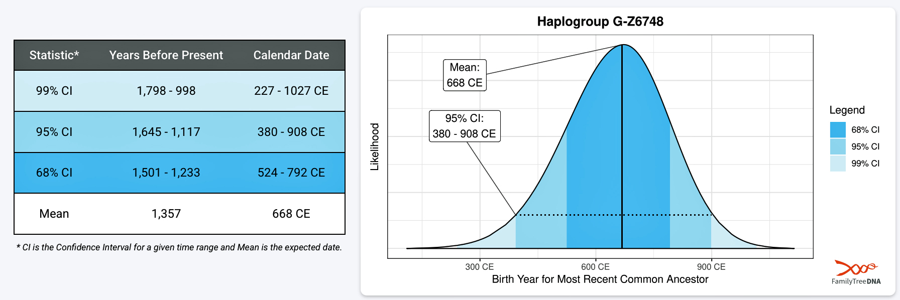


