Auswandererkarten or German Emigration Maps

There was a point in my long and focused research to document the immigration of our German ancestors that I came upon a map in my research. The map is 49 x 65 centimeters or about 19.3 x 25.5 inches in size.

The map was created in the early 1850s and, it contained a wealth of information about major German immigration routes to America. The map documented inland European travel routes to specific intercontinental ports of departure to the United States. The map also documented various inland routes from American ports to various cities in America. The map also provided information on the main routes for immigrants traveling in North America, measured in miles and the estimated time and cost of travel.

The map graphically portrayed the German immigrant experience in the mid 1800s in one page. It captured the gist of what I had documented through many hours of research. It was one of those moments that you look at the map and say to yourself, “Why didn’t I find this map before I started this research journey?“. While my research substantiated and explained in more detail what was depicted in the map, having the map at the beginning of the research process would have provided a great starting point.

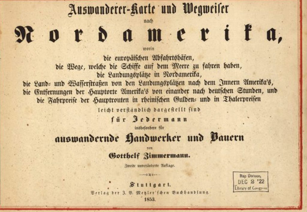
The map is the “Auswanderer-Karte und Wegweiser nach Nordamerika” (Emigrant Map and Guide to North America), published in Stuttgart in 1852-1853 by Gotthelf Zimmermann. [1]

Map One: Zimmermann’s Emigrant Map & Guide to North America
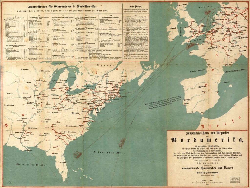
See also a 1970 x 1478 pixel sized version of the map.

The Significance of Auswandererkarten

Auswandererkarten, or German emigration maps in the mid 1800s offered detailed information about migrating to the United States. Special maps like the 1853 “Emigrant Map and Guide to North America” were published in Germany to aid emigrants, providing detailed travel information on routes, ports, and settlements in the United States.

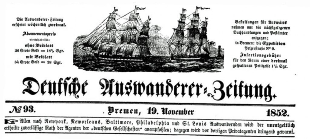
Emigration maps were published as separate items for guidance, advertised in German newspapers and were published as part of emigrant guides and handbooks. These maps, together with the weekly posting of departing ship schedules in German newspapers satisfied the needs of a growing market of German emigrants heading to the United States in the 1830s through 1850s.

The emigration maps provide a wealth of information, graphically depicting the predominate immigration routes in the mid 1800s. The routes are based on the transportation networks (e.g. road, canal, and rail) and major ports of departure and ports of entry that existed at the time. They capture an historical and visual snapshot of the development of the transcontinental transportation network that Germans utilized in the mid 1800s to immigrate to the United States. [2]

Here are some key details and general observations about these emigration maps :

  • They provided information for Germans planning to emigrate to the United States and other parts of North America, showing specific routes, travel times, ports of arrival, and potential settlement locations.
  • The maps were at times part of written travel guides with practical advice for emigrants on the journey, arrival ports, transportation options, costs, and life in America.
  • They were published by book publishers, map makers, emigration societies and travel agencies catering to the large numbers of Germans emigrating in the nineteenth century.
  • By depicting the routes, travel information and settlement locations, these maps provide a reflection of where Germans migrated to specific areas in North America.
  • From an historical perspective, these maps reflected the current outlines of the transportation infrastructure in Europe and the United States.
  • The maps provide a prescient graphic outline of the immigration patterns of where Germans eventually settled in the United States.

The Relationship of Emigrant Maps and Migration Patterns

These emigration maps did not cause massive upswings of Germans immigrating to the United States. Nor did they have a significant influence on the migration and settlement patterns of German immigrants in America. [3] This line of reasoning is akin to saying that since fireman are always around fires, they cause fires. To mix metaphors, it is a bit of the tail wagging the dog.

In a book, ‘A History of American in 100 Maps’, Susan Schulten chose this map as one of the hundrend influential maps of the United States. “The maps in this volume were made in vastly different contexts. Yet when considered together, they underscore the persuasive power of cartography.” [4]

Schulten points out that richly colored map was part of the large corpus of immigrant literature associated with the immigrant expansion of the United States in the mid 1800s.

“At first glance, it shows prospective emigrants a range of destinations that awaited them … . But a closer look shows not only patterns of immigration but also the more fundamental dynamics that contributed to the Civil War.”

“… (W)hile this map was designed for one purpose, it inadvertently reveals a much larger set of forces that increasingly differentiated the slave-based agricultural economy of the South from the free-market wage economy in the North. And by guiding immigrants to the latter, the map actually helps us understand the way that immigration was both a cause and consequence of that growing regional distinction, which ultimately led to the sectional crisis.” [5]

I believe the above quote correctly points to ‘a larger set of forces‘ that influenced German migration in the antebellum United States. The map also reflects the imbalance of the growth of the transportation infrastructure between the northern and southern states in the mid 1800s.

Whether the map and other emigrant maps played an influential role in guiding immigrants to the north is subject to debate. The above quote does not imply this map or German immigrants had a fundamental role in the emerging differences between the north and the south. Schulten’s observations point to the map’s reflection of the current state of affairs in the mid 1800s.

Based on various historical studies of immigrant letters and chain migration, maps and other forms of publications did not necessarily play an active, casual, or dominant role in directing immigrants to particular areas of the United States or actively guide or steer immigrants to the northeast and mid-west regions of the antebellum period. Maps of the 1850s were the reflection of the regionalized industrial growth in the United States. [6]

Whether one does immigration history by the numbers or by the letters, the results show a striking congruence. The decision to emigrate was very much a bottom-up decision. Private sources of information, above all immigrant letters, were much more influential than any public sources, be they guidebooks or state immigration agencies, in determining immigrants’ destinations. [7]

While opposition to slavery was widespread among nineteenth century German immigrants and many were active abolitionists, their attitudes were complex and varied by individual, class and circumstance. Views on the issue of slavery were not a major cause of migratory patterns. [8]

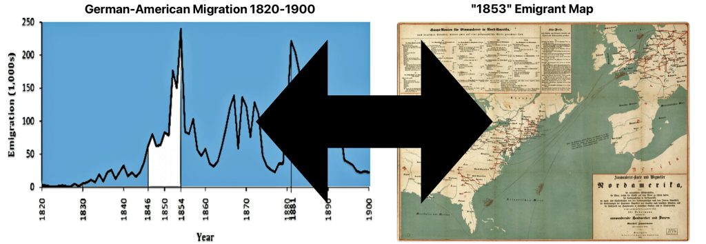
Illustration One: A Spurious Correlation: Emigration Maps and German Immigration Trends and Migratory Patterns
Click for Larger View

The views or conclusions about the influence of maps and publications on immigrant patterns are examples of what I believe to be a spurious correlation between the existence of emigration maps and migration trends and patterns. In this instance, a spurious correlation gives the false appearance of a causal relationship between two variables (e.g. maps and German emigration), when in reality the association is due to both variables being influenced by a number of other factors (e.g. push and pull migration factors, chain migration patterns, transportation infrastructure development in Europe and America, the refinement of packet ships and their schedules, etc). Identifying spurious correlations requires a careful analysis of the evidence and teasing out the effects of potential confounding variables.

Emigrant maps, in general, were specific tools to facilitate an emigrant’s journey. They did not necessarily promote or determine an emigrant’s path. However, like maps in the twentieth century, I would imagine maps in the mid 1800s in Germany may have sparked ideas of adventure or bolster decisions to make decisive moves to America in the minds of some. For the most part, they were an aid in helping immigrants that had already made their minds up in emigrating to a specific area or region of the United States.

In a society dominated by small towns and villages, horizons were narrow, local sentiments strong and information passed between generations and those you knew. The decisions made by German emigrants were not made in a vacuum. Local and regional socio-economic and political factors created a set of unique ‘push’ factors for them to consider emigrating from their homeland.

Their subsequent journey to America was also influenced by information they may have garnered from local community members who had descendants who migrated to America in the late 1700’s and early 1800’s. Travel agents and brokers, and German publications, such as maps, also provided to some degree information that may have facilitated their decisions to emigrate and guided their specific paths to their destinations..

As stated in prior stories, the areas in Germany where our relatives migrated from had a long tradition of migrating to America. Their specific route getting to America was different from the Baden emigrants in the 1700s and early 1800s. However, there may have been a strong likelihood that they followed the guidance from past generations from their local communities to settle in places that prior generations had settled or use those places as starting points to go further. Even without specific contacts, they may had at least a general idea of settling in the ‘Palatine area’ along the Mohawk River in New York state where past generations originally settled.

Regardless of the relative influence that emigrant maps may have had on emigration patterns, Zimmerman’s emigrant map provides an amazing, graphic snapshot of possible German migratory patterns in the mid 1800s. It is a great 1850s version of the contemporary travel map of the twentieth century.

(O)ld maps are valuable as both records and agents of history. Across five centuries, artifacts such as these have guided exploration, conquest, and settlement but also politics, commerce, science, medicine, education, bureaucracy, reform, and entertainment. Whether made for military strategy or moral reform, to encourage settlement or investigate disease, maps both reflect and mediate change. They tell us what people knew, what they thought they knew, what they hoped for, and what they feared. They invest information with meaning by translating it into visual form, thereby reflecting decisions about how the world ought to be seen. They capture the irreducible complexity and contingency of the past. Above all, they remind us that the past is not just a chronological story, but a spatial one as well.” [9]

Advertisements for the Auswanderer-Karte und Wegweiser nach Nordamerika

The “Auswanderer-Karte und Wegweiser nach Nordamerika” (Emigrant Map and Guide to North America) was published in Stuttgart, which was located in the Kingdom of Württemberg, around 1852. This is around the time that ancestors of the Griffis family emigrated from Baden. This is the year that John Speber departed from Le Havre to New York. It is five years after Catherine Fliegel departed from Le Havre for the port of New York city. It is three years before the remainder of the Fliegel family embarked from Le Havre to New York City.

The map was published by J.B. Metzler. The J.B. Metzler publishing house was one of he oldest publishing houses in Gemany. It was founded in Stuttgart in 1682 by August Metzler. [10] Metzler advertised the emigration map in German papers and offered special rates for bulk orders by emigration agents. [11]

While the map is often referenced as the ‘1853 German Map’, its existence is documented prior to 1853. For example, the pamphlet or map is referenced in an advertisement in the newspaper Leipziger Freitag in September 1852 [12]

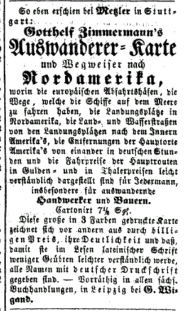
Advertisement for Zimmermann’s Map in the Leipziger Zeitung, September 1852

The advertisement states:

“Mesler in Stuttgart has just published: Gotthel Zimmermann’s emigrant map and guide to North America”

Emigrant Map and Directions to North America, containing the European ports of departure, the routes that the ships follow at sea, the disembarkation points in North America, the land and water routes from the disembarkation points to the interior of America, the distances of the main American towns and cities (Hauptorte) from one another in German hours, and the cost of the trip on the main routes in guilder and thaler. Presented in an easy to understand form for everyone, especially emigrating artisans and farmers.

Cartonized 7 1/2 Silver Groschen

“This large map, printed in 3 colors, is distinguished above all by its cheap price, clarity and basics, so that it is easier to read in Latin script for the less inclined, all frames are given in German print.”

Another example of an advertisement for the map was found in the newspaper, Kempter Zeitung, in March 1854. [13]

Advertisement for Zimmermann’s Map in the Kempter Zeitung, Mar 12 1854

The following is a translation of the advertisement.

“Zimmerman, Emigrant Map and Guide to North America in which the European ports of departure, the landing places in North America, the land and waterways from these landing places to the interior of America, the distances of the main places in America from each other according to German hours, the of the main routes in Rhenish guilders and in prussian thaler are presented in an easily understandable way. Fourth edition. In case. Price 24 fr.”

The map was listed in a German book bibliography, Allgemeines Deutsches Bücher-Lexikon, as late as 1858. The Allgemeines Deutsches Bücher-Lexikon was a comprehensive German book lexicon or bibliography published in the 19th century. [14] The map was advertised in German newspapers and sold in multiple editions through the late 1850s, indicating demand for such emigration maps.

The Audience and Marketing of the Map

The map was intended for a specific audience: Germans who had an interest or plans for immigrating to America. The introduction of the Map, found in the lower right corner of the map states:

“Emigrant Map and Directions to North America, containing the European ports of departure, the routes that the ships follow at sea, the disembarkation points in North America, the land and water routes from the disembarkation points to the interior of America, the distances of the main American towns and cities [main places] from one another in German hours, and the cost of the trip on the main routes in guilder and thaler. Presented in an easy to understand form for everyone, especially emigrating artisans and farmers.”

“Gotthelf Zimmermann. Second Edition”

“North (Nord) America” in Fraktur Calligraphy

With the exception of the title of the map (which appears to use Textra print [15] ), the map is using Fraktur typeface which was a common typeface of the day. Fraktur type was used for printing in Germany throughout the nineteenth century. Frakur typeface became the most common German blackletter typeface from the mid-16th century until the early 20th century. [16] As the description of the map states: the map ispresented in an easy to understand form for everyone, especially emigrating artisans and farmers“.

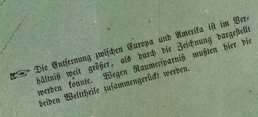
The map was intended to be published to fit on one piece of paper. The goal obviously was to fit both northern Europe and the United States and related information on the face of one piece of paper. The ability to fit this geographical space onto one page necessitated the need to take liberties on the accuracy of scale. This is explicitly mentioned in a note that was placed in the middle of the Atlantic ocean near Spain. The European countries and the American states are also not to scale on the map.

Annotation In-Between the Two Continents on the Map [17]

“The distance between Europe and America is relatively far greater than could be shown in the drawing. To save space, the two parts of the world had to be brought together here.”

Information on Travel Distance and Cost

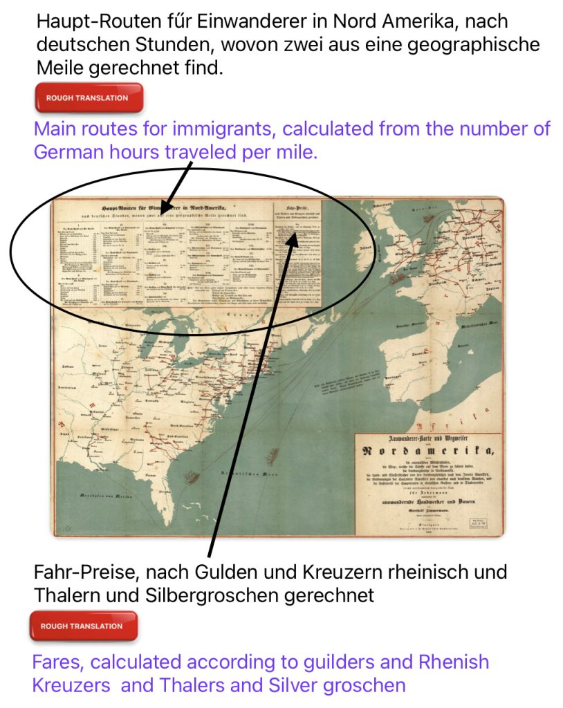
In the upper left hand corner of the map, traditional Fraktur German typography identifies cities and towns, and the distance and travel cost from each of the ports along the Atlantic coast to the interior towns and cities. Cost is provided in guilders, kreuzers and silver groschen. [18]

Illustration Two: Travel Time and Cost of Travel in the Zimmermann Map
Click for Larger View

An Example of a Baden Kreuzer

Six Kreuzers – Lepold I, Issued by the Grand Duchy of Baden (1830-1852) Source: 6 Kreuzers – Leopold I, Numista, https://en.numista.com/catalogue/pieces36798.html

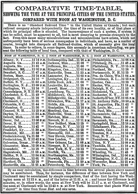
Comparative Time Table of Time 1868 [19]
Click for Larger View

(F)or example, when it was noon in New York, it was 11:10 in Indianapolis, 11:19 in Cincinnati, 11:24 in Columbus, 11:30 in Cleveland, 11:36 in Pittsburgh, 11:56 in Philadelphia, and 12:12 in Boston—that is to say, local time was defined relative to the sun at midday.”[20]

It is not known what “nach deutschen Stunden“, by German hours, means in the context of Zimmermann’s calculation of the amount of time to travel between designated cities. It is not known if ‘German time’ implies the use of a standardized base for computing time for the figures found in the map. This could be possible since time was not standardized in the United States.

The growth of railroads in the 1800s exposed the problems with every locality having its own solar time, and drove the adoption of standardized time zones that enabled more efficient train scheduling and safer operations. But this transition occurred gradually over many decades. In the early-to-mid 1800s, each town kept its own local time, usually based on “solar time” where noon was when the sun was highest in the sky. This meant adjacent towns could have slightly different local times. Railroads initially had to deal with this patchwork of local times when scheduling trains. [21]

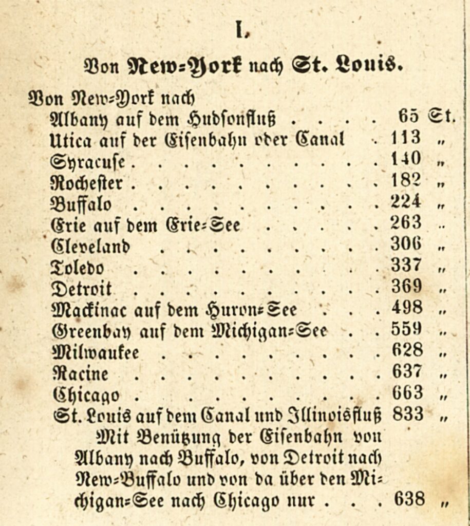
The map lists twenty-one combinations of trips and their distances from major United States cities. For example Part I lists routes from New York to various inland destinations.
Click for Larger View

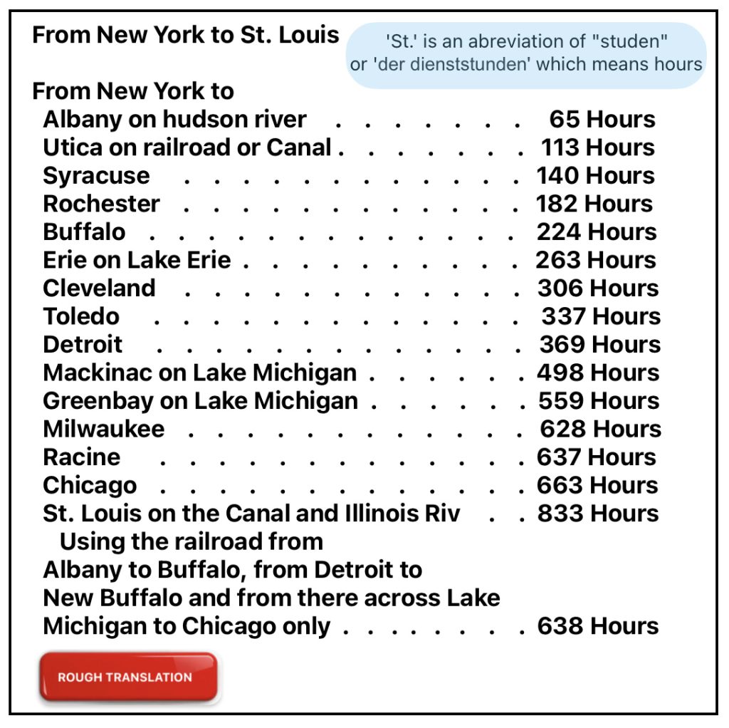
The following is a rough translation of the estimated time in hours it took to travel between New York City and the various destination points.
Click for Larger View

It is not clear what mode of transportation was used to calculate the estimated number of hours to travel to each of these various places. I am assuming many of the above travel routes between New York and the various places listed were based on travel by water.

Comparing the estimated time for travel in the Zimmermann map with American travel guides published around the same time period suggests the ‘Zimmermann travel’ was based on travel on canals, rivers, or lakes.

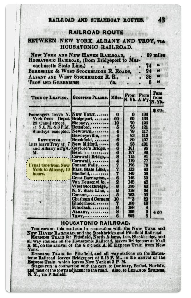
This is obviously the case traveling to “Albany on the Hudson River” (nach Albany auf hudsonfluss). For example, the Zimmerman map indicates the trip between New York city and Albany was estimated to be 65 hours in 1853 (perhaps based on data earlier than 1853 since that was the publication date). An 1851 travel publication indicated a train ride from New York to Albany took 10 hours (see below)

Travel on the Housatonic Railroad between New York City and Albany 1848 [22]

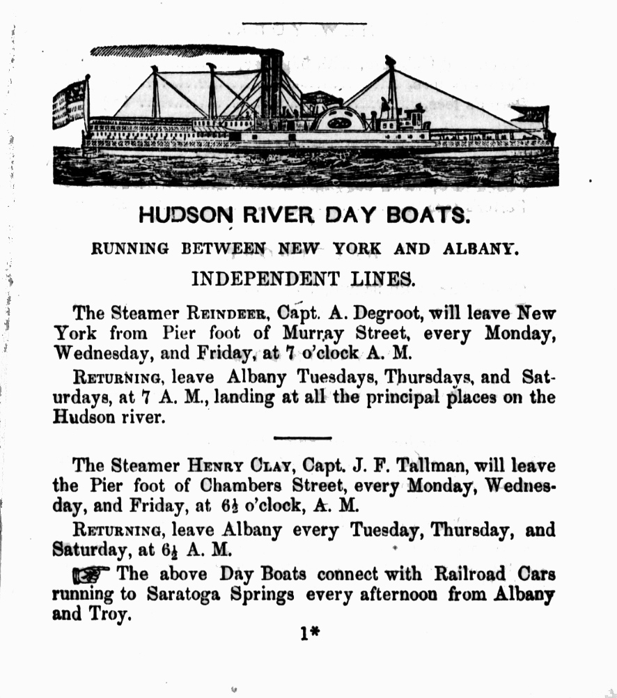
Hudson river days boats were also available in 1851 (see below). [23] Whether German immigrants utilized these boats or other slower vessels to travel further inland in New York state is not certain.

Hudson River Day Boats to Albany
Click for Larger View

Major Land Routes in Europe Portrayed in the Map

The ‘1853’ map was the second edition of Zimmermann’s map. As such it purportedly represents knowledge of the transportation networks in Europe and the United States around that time.

There is no explicit legend defining what the red lines denote or mean in the map. It is not known if the red routes on the map are intended solely to denote railways or routes that include roadways and railways. Canals and rivers are in blue or grey (depending on what version of the map you are viewing).

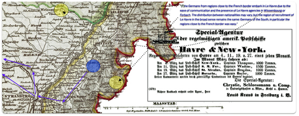
Map Two: Highlighted Possible Immigration Routes for John Sperber in 1852 on the ‘1853’ Zimmemann Map

Based on an historical analysis of German migration, we know that the red routes in the map signify popular routes that German emigrants had taken to major European ports of departure for America between 1830 to the 1860s and perhaps onward. However, based on the historical development of French and German railway networks around 1850-1852, I believe the red routes on the map signify routes that include a combination of road and railway travel not just rail travel. (See map two)

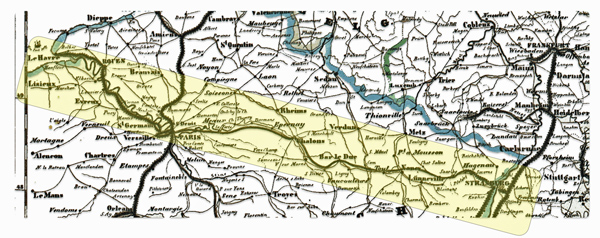
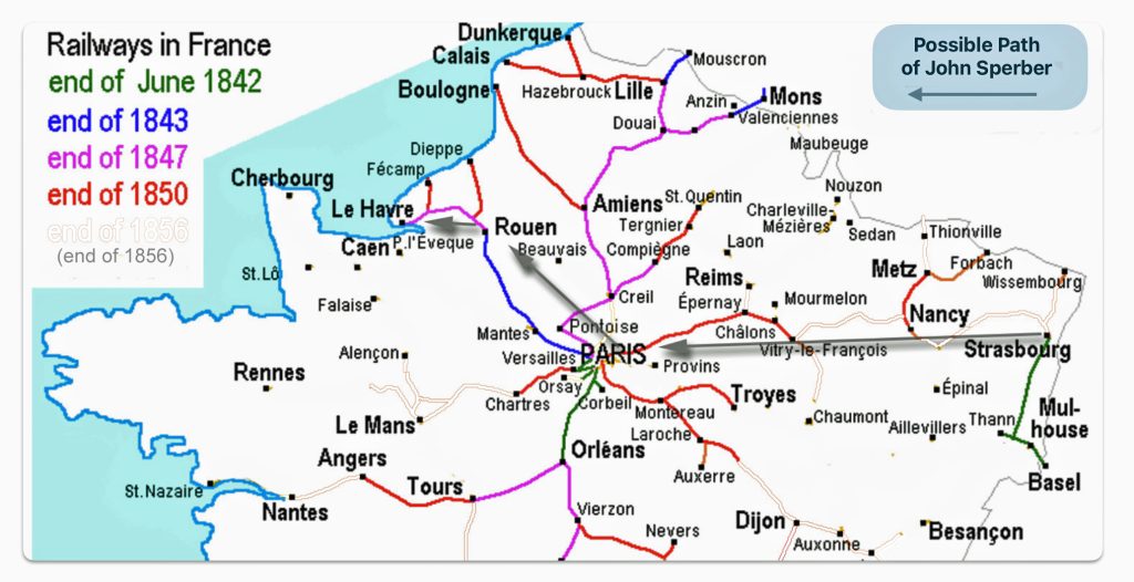
As indicated in a prior stories, a great great grandfather of mine, John Sperber, immigrated to America from Baden-Baden, Grand Duchy of Baden which is close to and on the other side of the Rhine River to Strasbourg, France. Based on historical evidence, I believe he traveled from Baden-Baden to Le Havre France and departed in 1852 to New York City. At the time of his journey the railway lines between Paris and Strasbourg were not complete. (See map three below)

If John traveled by railway, his options were limited. The rail line between Paris and Strasbourg was built and operated by the Compagnie du chemin de fer de Paris à Strasbourg, which later became part of the Chemins de fer de l’Est This railway line between Paris and Strasbourg was complete after John arrived to the United States in 1852. It was not available for him when he emigrated to the United States.

The first section of the French railway line between Le Havre and Strasbourg was opened in 1849. This first section connected Paris to Châlons-sur-Marne (see map three below). In 1850 a line from Nancy to Frouard and a line from Châlons to Vitry-le-François were completed. In the following year, a line from Vitry-le-François to Commercy as well as a line from Sarrebourg to Strasbourg were completed. Finally, in 1852, the year John Sperber emigrated, the sections between Commercy and Frouard, and the line between Nancy and Sarrebourg were opened. The 1852 sections were probably open after John’s voyage in June 1852.  [24]

During this period, railway technology and infrastructure were rapidly developing. The rapid development had its impact on the production of maps. It has been observed that for American maps “even the most accurately drawn map which spent a month or two in production might miss more new railroad mileage during these years than had existed in the entire country in the 1830s or early 1840s. Some mapmakers tried to anticipate this fluidity by building their expectations for expansion into their maps, only to see those plans unrealized as funding fell through or construction was temporarily halted.” [25] I imagine this was an issue faced by the German and French map makers as well.

As reflected in map three, I have modified and removed from the original source map all of the rail lines that were built between 1850 and 1856. You can see of illustrative purposes, however, remnants of removed lines for the railways completed in this six year period. John Sperber may not have been able to travel by rail between Strasbourg, Nancy and Vitry-le-François. Even if they were able to travel by train, his journey would have been interrupted and punctuated with the need to travel by roadways where the train line was under construction. [26]

Map Three: French Railway System 1842 – 1850

Many of the major contemporary road arteries in France follow the routes of royal postal roads that were originally built in the 1700s. The French postal roads of the 1700s were innovative in their design and construction. Many of the these postal routes survived and became the major roadways in France. In fact, all of the roadways in the along the route from Strasbourg to Le Havre in 1853 are part of the old postal route system.

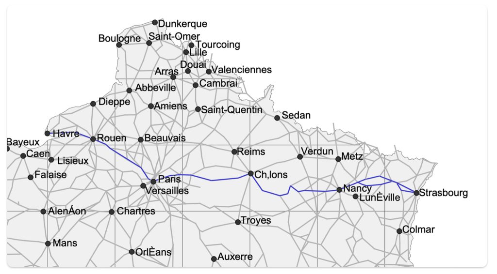
Map four below depicts the postal roads in northern France that linked major towns and cities in France in 1833. The creation of the map is the result of analyzing the changes over time of the expansion of postal routes in France through time. I have highlighted the postal roads that followed the possible route that John Sperber had taken to reach the post of Le Havre.

Based on the above analysis, I believe the Zimmermann ‘red route’ between Strasbourg and Le Havre merely denotes a popular route to Le havre that included roadway and railway, depending on when one traveled across northern France.

Map Four: French Postal Roads and Main Cities and Towns in 1833 and the Highlighted Possible Route of John Sperber from Strasbourg to Le Havre [27]
Click for Larger View

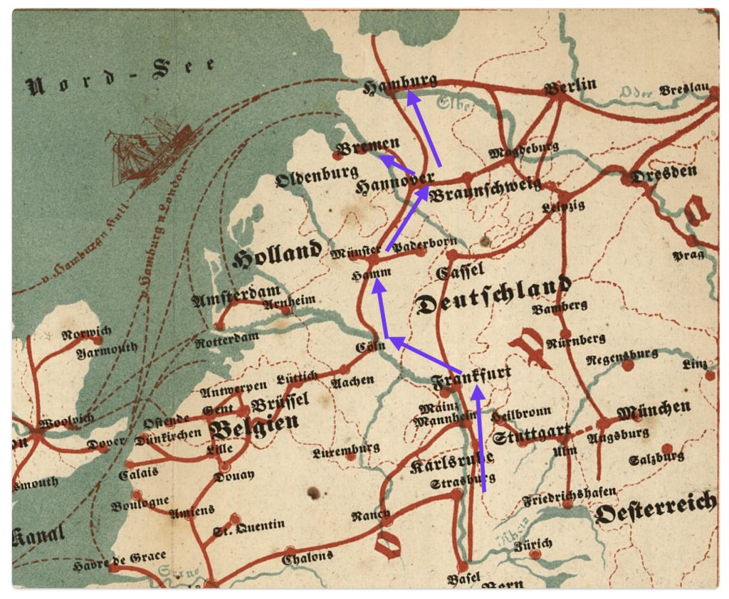
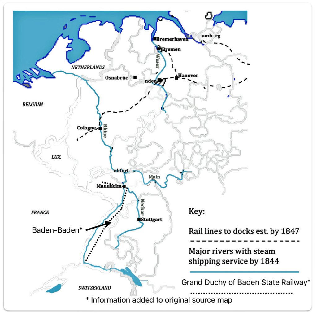
Between 1850 and 1853, the Baden to Bremen route probably was an effective alternative route for John Sperber’s consideration or others from the Grand Duchy of Baden. Bremen could have been reached by roadways from Baden. Bremen could also be reached through the use of a combination of train (Baden Main Line), waterway (the Rhine River to Cologne) and then rail via Hanover and Bremen. (See map five)

Map Five: Major Interior Rivers Served By Steam Transportation & Rail Lines to Docks of Bremen and Hamburg, 1847 [28]
Click for Larger View

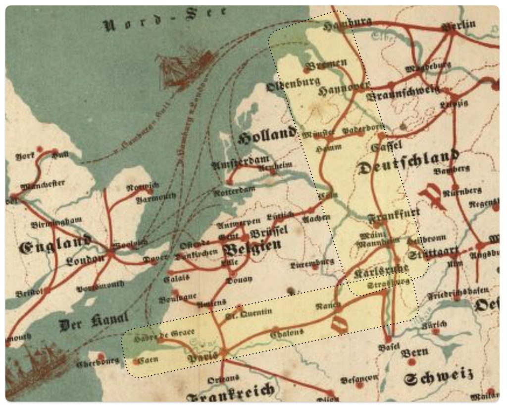
Map six below is a portion of Zimmermann’s map that shows the same route that is reflected in map five.

Map Six: Portion of Zimmerman Map Showing Route from Baden-Baden to Bremen and Hamburg

Based on historical evidence on the development of German railways in the 1840s and 1850s, it is reasonable to assume that the red travel paths in the Zimmermann map for this particular “Baden to Bremen” route denote rail lines connected with waterways .

Depending on the specific popular routes in the Zimmermann map, the red lines may denote railways or roadways. Nonetheless, the emigrant map serves its purpose of providing a simplified depiction of the major routes to outgoing European ports.

Major Inland Routes in America Portrayed in the Map

The first thing that comes to mind when viewing the American cities and towns in Zimmermann’s map is why some of these locations were chosen and not others. Many of the cities in the map were obvious choices given German immigration patterns since the early 1800s.

“The sheer volume of detailed information in the map … raises the question of how the mapmaker assembled it. What advertising and promotional materials could he draw on? Newspapers? Firsthand reports from sales agents or people who had already emigrated? Related guidebooks or maps? Train and ship schedules? In any case, the information conveyed by this map was part of a broader ecosystem of knowledge of varying reliability bound up with the experiences and agency of those who had made or would make the journey.” [29]

Zimmermann may have obtained information for his map from various sources. He may have utilized the information contained in other German emigration maps, newspapers, and popular German travel and immigration books as a reflection of accumulated knowledge of migration. Information on travel schedules and major shipping routes were readily available in German newsprint.

Zimmermann may have also relied on pocket travel guides that were published in America. Many guides contained multiple large scale maps. These travel guides and maps often provided detailed depictions of travel routes, such as bridges and tunnels that are not easily seen on other, larger maps.

“Probably the best (American) nineteenth century railroad maps were those which appeared in “pocket” travel guides. Appearing first in the 1840s, some were published monthly; others, semi-annually or annually, often under slightly changed names. … Each went through many editions.” [30]

The Zimmermann map highlighted the major American port cities of the mid 1800s like New York, Philadelphia, Boston, Baltimore and New Orleans. New York was major port of entry during the time period.

“Her connection with the interior was a prime cause of New York’s commercial supremacy, and the two together account for the growing favor shown her by immigrants. In the middle of the century Buffalo, Cleveland, and Milwaukee were the distributing points for those bound to the Northwest, and to reach these cities the Erie Canal and, after 1846, the railroad from New York to Buffalo were by far the quickest and the cheapest routes. For those bound to the Middle West, Wheeling, Pittsburgh, Cincinnati, and St. Louis were the distributing points; and for reaching them New York offerred facilities as good as those from Philadelphia and better than those from Boston or Baltimore. New Orleans was favorably situated for such as were bound for the Mississippi Valley and she did receive a considerable number of immigrants; but the voyage was two or three weeks longer than to New York, the ships sailing thither from Europe were inferior, the journey up the Mississippi to St. Louis was unpleasant, dangerous, and little shorter than from New York, and above all, the dread of yellow fever and other maladies common among strangers in a southern climate combined to deter most Europeans from choosing that route.” [31]

The Zimmermann map also identifies inland cities in the midwest that were popular destinations for German immigrants. In the nineteenth century, German immigrants settled in Midwest, where land was available. Cities along the Great Lakes, the Ohio River, and the Mississippi and Missouri Rivers attracted a large German element. The Midwestern cities of Cleveland, Cincinnati, Fort Wayne, Milwaukee, Cincinnati, St. Louis, Chicago were favored destinations of German immigrants. The Northern Kentucky and Louisville area along the Ohio River were also a popular destinations.  Dubuque and Davenport, Iowa and Omaha, Nebraska, were also areas where Germans settled.  By 1850 there were 5,000 Germans in Ann Arbor, Michigan. [32]

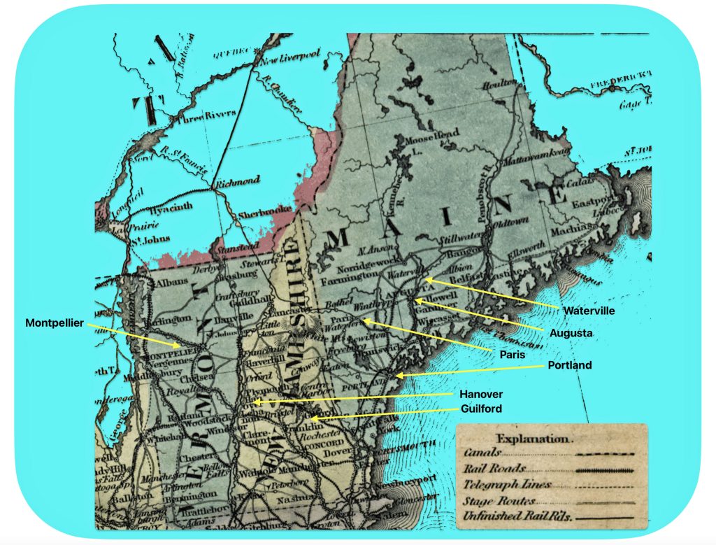
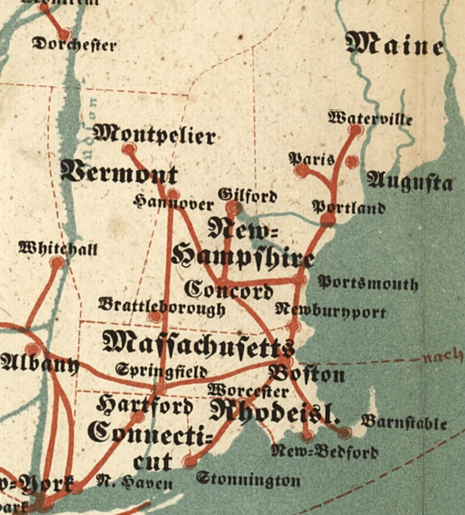
The presence of smaller cities and towns on the Zimmermann map are a bit puzzling, perhaps due to my lack of knowledge of the history of the towns. Smaller inland towns like Guilford and Hanover in New Hampshire; Montpellier in Vermont; and the Maine towns of Portland, Waterville, Augusta and Paris are identified along red routes on the map. Perhaps these towns were noted on the map based on reports from earlier German migrants, earlier settlements or efforts by land developers to attract settlers. [33]

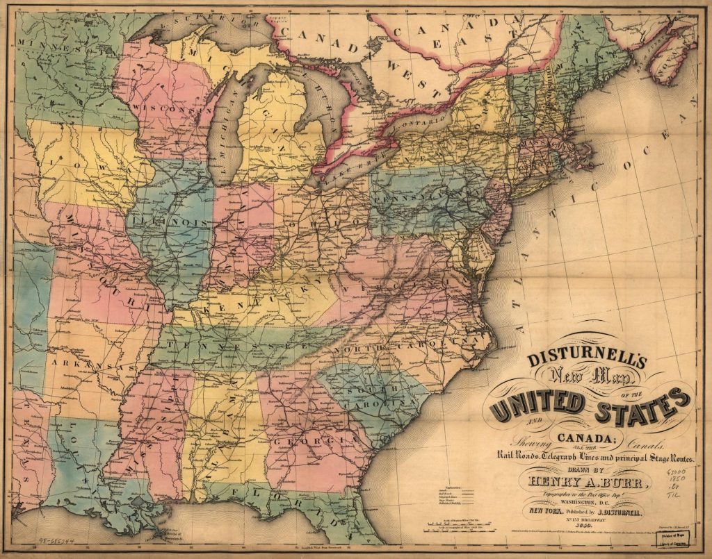
It is interesting to compare Zimmermann’s simplified, elegant emigrant map with a more detailed American map that shows canals, railroads, telegraph lines and principal stage routes. [34] If compare the transportation networks that existed in 1850 (see map seven) with the simplified ‘1853’ Zimmermann emigrant map (see map eight), one can see the transportation links with the above mentioned towns and cities in Vermont, New Hampshire and Maine. All of these towns had rail connections.

Map Seven: Vermont, New Hampshire, and Maine 1850 [35]

Map seven depicts railways, roadways, and waterways. As evident in the 1850 map, the towns highlighted in Zimmermann’s map are linked to other towns through railways, waterways and roadways.

Map Eight: Portion of Zimmermann’s Emigrant Map: Vermont, New Hampshire, and Maine
Screenshot

Similar to my conclusion regarding what the red lines denote for travel paths on the European continent, I believe the red lines depicting travel routes to inland cities in the United States also represent ‘popular routes’ that are a combination of roadways, railways and waterways.

Comparing Transportation Networks in the 1953 Zimmermann Map and German Population Density in 1870

While this map was designed for the purpose of providing guidance to German immigrants for planning travel to the United States, it provided a ‘snapshot’ of the current state of affairs for German émigrés that traveled to America.

Railroads and waterways, natural and man made, had a significant influence on German immigration and settlement patterns in the United States during the 19th century. In the 1700s and early 1800s, a majority of German immigrants settled in cities and rural areas near the major ports on the eastern seacoast roadways and waterways increased their travel inward on the American continent. [36]

In the central part of America, many German immigrants initially settled in cities along major waterways like the Missouri and Mississippi Rivers, as these provided transportation routes into the frontier. Towns with large German populations developed along the Missouri River in the early to mid-1800s. [37]

The opening of the Ohio & Erie Canal in the 1830s attracted more German immigrants to settle in Cleveland and other cities in Ohio. Canals in general improved transportation and opened up new areas for settlement before railroads became dominant. [38]

Railroad construction in the mid to late 1800s enabled German immigrants to travel further inland to establish new settlements, especially in the Midwest. Many Germans worked as laborers to build the railroads. As railroads expanded, new waves of German immigrants arrived and often settled in areas that already had established German communities. However, the core areas of German settlement did not significantly expand, with the exception of a few new settlements along railroad lines in the 1870s-1880s. [39]

Railroads played a key role in the rapid growth of cities like Chicago, St. Louis and Milwaukee which developed large German populations in the late nineteenth century. There was a “German triangle” in the Midwest connected by rail between New York, Minneapolis, St. Louis and Baltimore where there was a concentration of German settlement.

While this pamphlet-sized map was designed for the purpose of providing guidance for planning travel to the United States, it provided a prescient future view of settlement patterns for subsequent generations of German-Americans. The significant influence on the history of American transportation networks on nineteenth century German immigration and settlement patterns is apparent if we compare Zimmermann’s map with density settlement patterns of Germans in 1870.


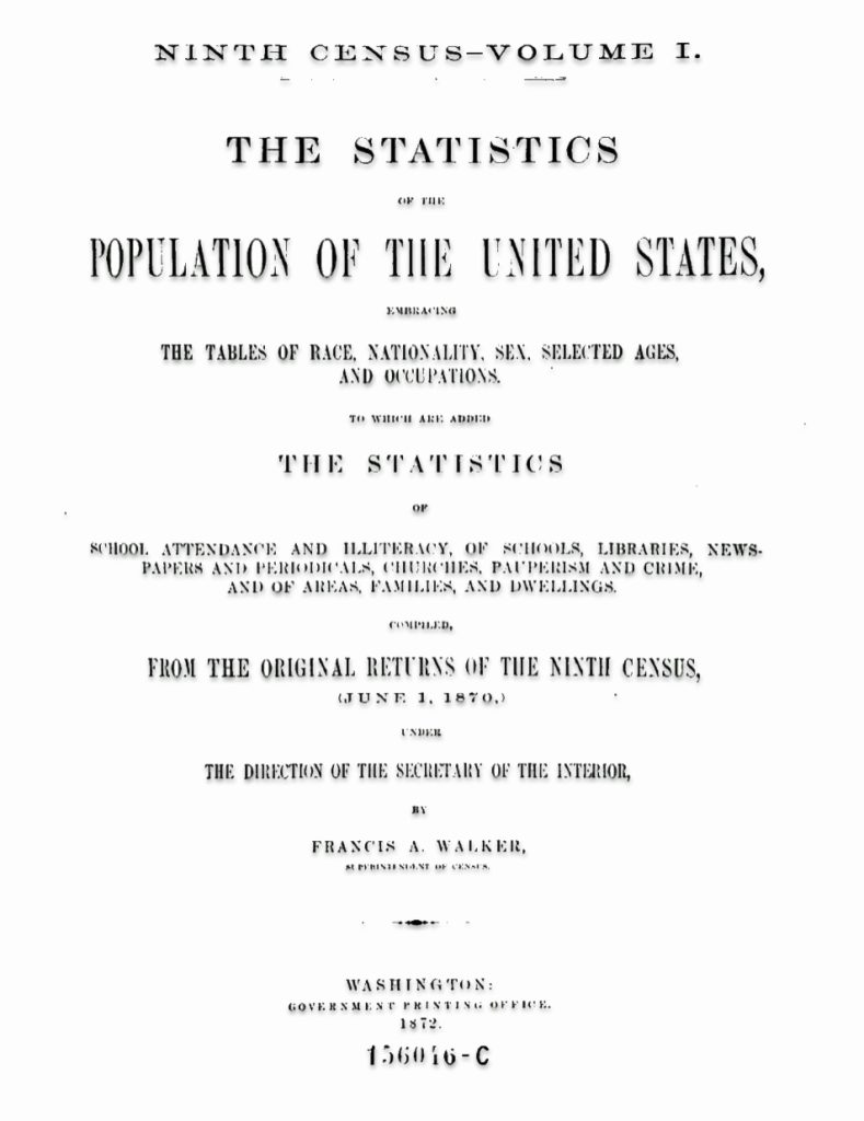
Title Page of 1870 CensusThe Statistics of the United States

Click for Larger View

“The 1870 census provided the nation with an astounding array of graphic and cartographic depictions of its state of geographic knowledge.” [40] A national atlas produced by the U.S. government was first realized in the Statistical Atlas issued by the Bureau of the Census with the 1870 census. The U.S. census had been transformed from a massive tabulating project to assist in apportioning Congressional representation among the states to a quantitative scientific accounting of numerous aspects of the nation’s many human geographies.

“Members of the fledgling American Geographical Society and American Statistical Society, including the geographer Daniel C. Gilman of Yale University, Samuel B. Ruggles of the American Geographical Society, and Edward Jarvis of the American Statistical Association, had attended meetings of the International Statistical Institute in Europe where new ideas concerning the graphic presentation of information were regularly discussed.” [41]

The 1870 census and its supplemental publications introduced more sophisticated capabilities for visualizing quantitative information, both graphically in charts and cartographically in thematic maps. The Census Office issued its first 1870 census thematic maps in its final reports, just before publishing the Statistical Atlas. These reports included a total of some twenty-six thematic maps.  [42] The atlas appeared as a complete volume in 1874.


Map nine is from the Ninth U.S. Census. It indicates the density of people of German descent living in the eastern half of the United States in 1870, twenty years after the publication of Zimmermann’s map. The 1870 U.S. Census map provides the population density patterns of people of German descent in the eastern portion of the United States. The U.S. Census map indicates that individuals of German descent are largely found along and above the Missouri and Ohio Rivers in the mid-west. The Mason-Dixon line appears to be an imaginary line for Germans settling in the United States. Individual of German descent are found in New York, Pennsylvania, parts of Massachusetts and Connecticut, the Great Lakes region above the Ohio River and along the Missouri River.

Map Nine: Density of German Population in U.S. in 1870
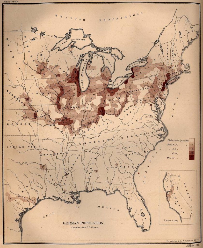
Click for Larger View | Source: A. de Witzleben, German Population 9th Census, Page 325, in Francis A Walker, Superintendent of Census, Ninth census – Volume I,  The Statistics of the Population of the United States, Washington, Government Printing Office, 1872,  Page 325, https://www.google.com/books/edition/Ninth_Census_volumes/0ngZm56S-7sC?hl=en&gbpv=1

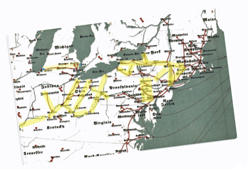
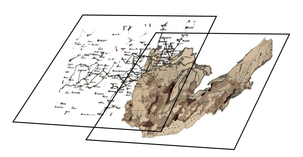
It is interesting to compare the density patterns of the German population in 1870 with the transportation routes depicted in Zimmermann’s map. I abstracted the transportation routes of the Northeastern United States from the Zimmermann map and I tried to overlay both maps. The latitudinal and longitudinal scales of each map are different. I was unsuccessful in modifying the dimensions of each map to make them conform and consequently was unable to overlay both maps to provide a visual comparison. The image below graphically shows what I was attempting.

Illustration Three: Attempted Overlay of Zimmermann’s Map with 1870 U.S. Census Density Map of German Population
Click for Larger View

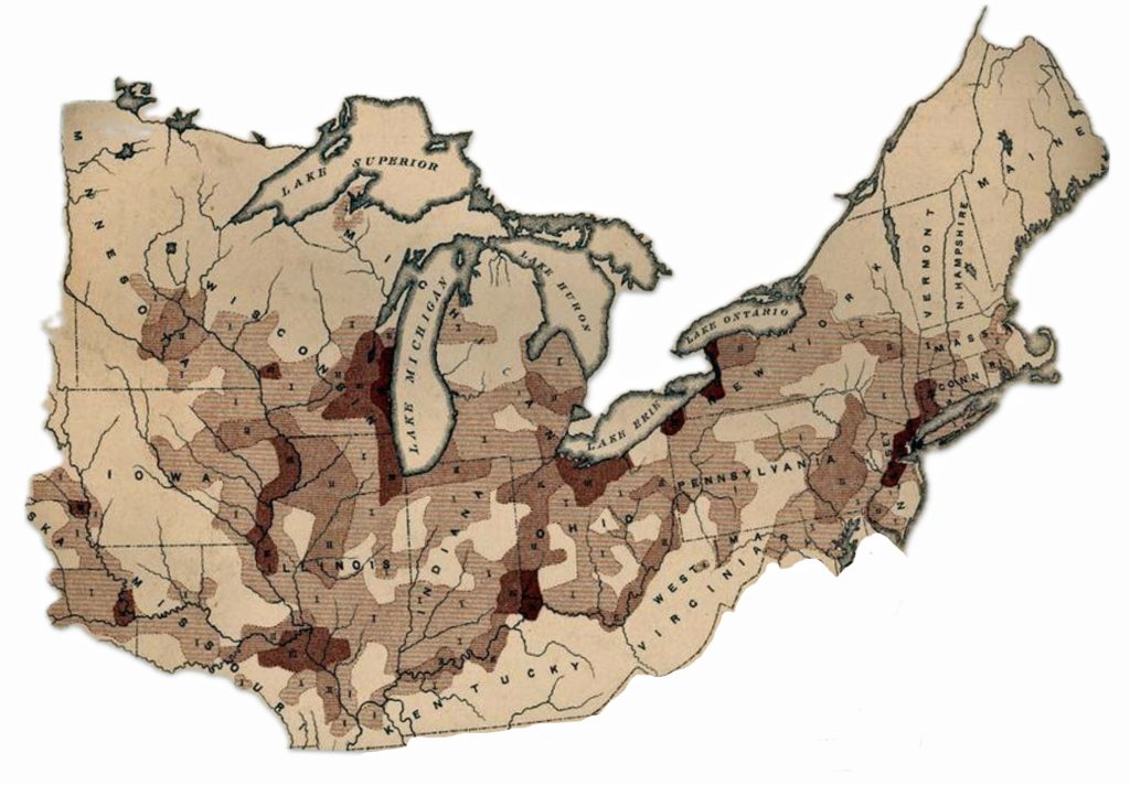
Despite my failure to meld and overlay both maps, if both maps are closely examined (maps ten and eleven), you can see that Germans ultimately settled along major transportation networks that existed in the 1850’s. Zimmermann’s map depicted the major transportation arteries to cities in the United States at this time. I have taken the northeastern portions of each map for comparison. In map eleven, I have highlighted in yellow the major routes in Zimmermann’s map that correspond with dense areas of German population in 1870.

Map Ten: Density of German Population in 1870 in North East and North Central United States
Click for Larger View

Map Eleven: Transportation Netweks Abstracted from Zimmermann’s Emigrant Map

The rapid development of rail lines and the pre-existing river transportation networks enabled and encouraged German immigrants to spread westward from initial entry points on the East Coast, concentrating in the Midwest and the Plains states that became the “German belt” in the 19th century. [43] The transportation infrastructure had a fundamental effect on the settlement patterns and density of German immigrant communities. [44]

German immigrants often traveled inland to the Midwest after arriving at ports like New York, Philadelphia, Baltimore, and New Orleans. They also to a lessor extent used the Mississippi, Ohio, and Missouri river systems to reach areas in the “German triangle” between Cincinnati, Milwaukee, and St. Louis where many of them settled. [45]

The expansion of railroads in the mid-1800s enabled German immigrants to more easily travel west from the East Coast to settle in the Midwest and establish farms. States in the “German belt” stretching from Pennsylvania to Oregon saw high concentrations of German settlement.

Cities along major waterways like the Great Lakes, Ohio River, and Mississippi River, such as Milwaukee, Cincinnati, St. Louis, and Chicago, became centers of large German-American populations in the 1800s. Access to both rail and water transportation supported rapid growth and industrialization in these areas.

A Map to Guide and a Map to Predict

Zimmermann’s map was a simple map that contained a wide range of information for German emigrants making their journey to America. While it served a very useful purpose in the 1850s, his map reflected the current outlines of the transportation infrastructure in Europe and the United States. It also provided a glimpse of the emerging graphic outline of the immigration patterns of where Germans and their families eventually settled in the United States.

Maps “record efforts to make sense of the world in physical terms. They capture what people knew, what they thought they knew, what they hoped for, and what they feared. They invest information with meaning by translating it into visual form, and in so doing reveal decisions about how the world ought to be seen. Above all, they demonstrate that the past was not just a chronological story but a spatial one as well. ” [46]

Sources

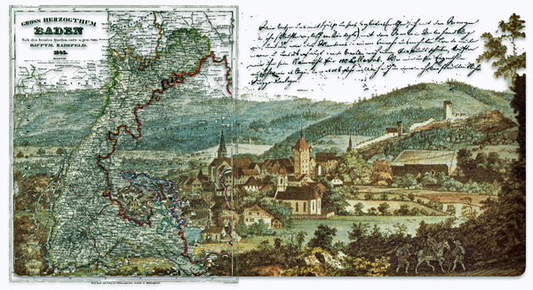
Feature banner: The banner is an amalgam of parts of the 1852-1853 immigration map that is discussed in the story.

Source: Gotthelf Zimmermann, Auswanderer-Karte und Wegweiser nach Nordamerika, 2nd ed. (Stuttgart: J.B. Metzler’schen Buchh., 1853), Library of Congress Geography and Map Division, Washington, DC, http://www.loc.gov/resource/g3701e.ct000244

[1] Zimmermann, Gotthelf. Auswanderer-Karte und Wegweiser nach Nordamerika. Stuttgart: J.B. Metzler’schen Buchh, 1853. Map. https://www.loc.gov/item/98687132/

[2] Ronald Grim discusses Grim, Ronald, Mapping Migration andSettlement, The Newberry, https://mappingmovement.newberry.org/mapping-migration/

For an interesting perspective on cartography andAmerican history, see: Mapping Movement, The Newberry, https://mappingmovement.newberry.org

[3] For example, a February 2024 Reddit discussion thread, titled “A German map of American ports and major cities, intended for use by travelers and immigrants to the United States, circa 1853. The German immigration wave to the US soared to then-record numbers around this time”, implies that the map had a substantial correlation with German migration to the United States. https://www.reddit.com/r/TheWayWeWere/comments/1ajwfvd/a_german_map_of_american_ports_and_major_cities/

Danzer, Gerald A. Danzer with James Akerman, American Railroad Maps, 1828 – 1876, The Newberry, https://mappingmovement.newberry.org/american-railroad-maps-1828-1876/

[4] Susan Schulten, A History of America in 100 Maps, Chicago: The University of Chicago Press, 2018, Page 9

[5] Schulten, Susan, How Maps Reveal, and Conceal, History, Progress: A Blog for American History, https://www.oah.org/process-blog/schulten-maps/

See also:

Susan Schulten, A History of America in 100 Maps, Chicago: The University of Chicago Press, 2018, Pages 138 – 239

[6] Kamphoefner, Walter D. “Immigrant Epistolary and Epistemology: On the Motivators and Mentality of Nineteenth-Century German Immigrants.” Journal of American Ethnic History, vol. 28, no. 3, 2009, pp. 34–54. JSTORhttp://www.jstor.org/stable/40543427

For a general review of research on German emigration and immigration, see Helbich, Wolfgang. “German Research on German Migration to the United States.” Amerikastudien / American Studies, vol. 54, no. 3, 2009, pp. 383–404. JSTOR, http://www.jstor.org/stable/41158447

See also:

Félix Krawatzek and Gwendolyn Sasse, Integration and Identities: The Effects of Time, Migrant Networks, and Political Crises on Germans in the United States. Comparative Studies in Society and History, 60(4), June 2018, 1029-1065. doi:10.1017/S0010417518000373 https://www.cambridge.org/core/journals/comparative-studies-in-society-and-history/article/abs/integration-and-identities-the-effects-of-time-migrant-networks-and-political-crises-on-germans-in-the-united-states/A5B951CA7AEB2C2C33958799C40FDDA2

See also other work of Krawatzek and Sasse where they developed a computer-aided textual analysis of about 6,000 letters sent between the US and Germany between 1830 and 1970. Their contents allowed the researchers to trace how migrants’ identities and transnational ties changed over the decades.  

Félix Krawatzek and Gwendolyn Sasse, Writing home: how German immigrants found their place in the US, February 18, 20016, The Conversation, https://theconversation.com/writing-home-how-german-immigrants-found-their-place-in-the-us-53342

Félix Krawatzek, Gwendolyn Sasse, The simultaneity of feeling German and being American: Analyzing 150 years of private migrant correspondence, Migration Studies, Volume 8, Issue 2, June 2020, Pages 161–188  https://doi.org/10.1093/migration/mny014

Félix Krawatzek and Gwendolyn Sasse, Deciphering Migrants’ Letters, November 28, 2018, comparative Studies in Society and History, https://sites.lsa.umich.edu/cssh/tag/krawatzek/

Walter D. Kamphoefner, Wolfgang Helbich, et al., Editors., News from the Land of Freedom: German Immigrants Write Home (Documents in American Social History) : Cornell University Press, 1991.

Karl Dargel, Tyler Hoerr, Petar Milijic,  Economic Migration: Tracing Chain Migration through Migrant Letters in an Economic Framework, Global Histories, Special Issue (Feb 2019) Pages 19 -30

Moltmann, Günter. “Migrations from Germany to North America: New Perspectives.” Reviews in American History, vol. 14, no. 4, 1986, pp. 580–96. JSTORhttps://doi.org/10.2307/2702202 Accessed 26 Sept. 2023.

Helbich, Wolfgang. “German Research on German Migration to the United States.” Amerikastudien / American Studies, vol. 54, no. 3, 2009, pp. 383–404. JSTORhttp://www.jstor.org/stable/41158447Accessed 26 Sept. 2023.

[7] Kamphoefner, Walter D. “Immigrant Epistolary and Epistemology: On the Motivators and Mentality of Nineteenth-Century German Immigrants.” Journal of American Ethnic History, vol. 28, no. 3, 2009, pp. 48. JSTORhttp://www.jstor.org/stable/40543427

[8] Barkin, Kenneth. “Ordinary Germans, Slavery, and the U.S. Civil War.” The Journal of African American History, vol. 93, no. 1, 2008, pp. 70–79. JSTOR, http://www.jstor.org/stable/20064257

Raphael-Hernandez, H., & Wiegmink, P. (2017). German entanglements in transatlantic slavery: An introduction. Atlantic Studies14(4), 419–435. https://doi.org/10.1080/14788810.2017.1366009

Anderson, Kristen Layne, Abolitionizing Missouri: German Immigrants and Racial Ideology in Nineteenth-Century America (Antislavery, Abolition, and the Atlantic World),Baton Rouge: Louisiana State Press, 2016

Efford, Alison Clark, “German Immigrants and the Arc of Reconstruction Citizenship in the United States, 1865-1877” (2010). Hist or y F aculty Research and Publications. 285.
https://epublications.marquette.edu/hist_fac/285

Biesele, Rudolph, German Attitude Toward the Civil War, Sep 1, 1995, Texas State Historical Association, https://www.tshaonline.org/handbook/entries/german-attitude-toward-the-civil-war

[9] Schulten, Susan, How Maps Reveal, and Conceal, History, Progress: A Blog for American History, https://www.oah.org/process-blog/schulten-maps/

[10] J.B. Metzler, Wikipedia, Diese Seite wurde zuletzt am 18. März 2024, https://de.wikipedia.org/wiki/J.B._Metzler

“Der J.B. Metzler Verlag ist ein traditionsreicher geisteswissenschaftlicher Verlag. Gegründet 1682, ist er einer der ältesten Verlage Deutschlands überhaupt. Verlagsort ist Stuttgart.”

The J.B. Metzler Verlag is a traditional humanities publisher. Founded in 1682, it is one of the oldest publishing houses in Germany. Publishing place is Stuttgart.

J.B. Metzle Publishing Website , https://www.metzlerverlag.de/der-verlag/verlagsprofil

[11] This is pointed out by Mark R. Stoneman in “An 1853 Map for German-Speaking Emigrants,” Migrant Knowledge, January 30, 2022, https://migrantknowledge.org/2022/01/30/an-1853-map-for-german-speaking-emigrants/

[12] Leipziger Zeitung, No. 218, Friday, September 10, 1852  Page 4329. https://www.google.com/books/edition/_/iPxjAAAAcAAJ?hl=en&gbpv=1&pg=PA4329&dq=%22Auswanderer-Karte+und+Wegweiser+nach+Nordamerika%22

[13] Kempter Zeitung, Mar 12 1854, No. 62   Page 254 , https://www.google.com/books/edition/Kemptner_Zeitung/ScVDAAAAcAAJ?hl=en&gbpv=1&dq=kemptner%20zeitung%201854&pg=PA254&printsec=frontcover

[14] This is pointed out by Mark R. Stoneman in “An 1853 Map for German-Speaking Emigrants,” Migrant Knowledge, January 30, 2022, https://migrantknowledge.org/2022/01/30/an-1853-map-for-german-speaking-emigrants/

Heinsius, W. (1858). Allgemeines Bücher-Lexikon oder vollständiges alphabetisches Verzeichnis aller … erschienenen Bücher, welche in Deutschland und in den durch Sprache und Literatur damit verwandten Ländern gedruckt worden sind. Germany: Brockhaus. Volume 12 https://www.google.com/books/edition/Allgemeines_Bücher_Lexikon_oder_vollst/4G6LLUh1isUC?hl=en&gbpv=1&dq=%22Auswanderer-Karte+und+Wegweiser+nach+Nordamerika%22&pg=PA519&printsec=frontcover#v=onepage&q=%22Auswanderer-Karte%20und%20Wegweiser%20nach%20Nordamerika%22&f=false

[15] Textualis, also known as textura or Gothic bookhand, was the most formal and calligraphic form of blackletter script, widely used for book production in Western Europe from the 12th to 15th centuries. Textualis was most widely used in France, the Low Countries, England, and Germany.

Blackletter, Wikipedia, This page was last edited on 30 April 2024, https://en.wikipedia.org/wiki/Blackletter

[16] Fraktur, Wikipedia, This page was last edited on 8 May 2024, https://en.wikipedia.org/wiki/Fraktur

Draper, Kelly, Fraktur Basics, Aug 17, Backlog Achivists and Historians, https://www.backlog-archivists.com/blog/fraktur

The History of Old German Cursive Alphabet and typefaces, German Girl in America Blog, https://germangirlinamerica.com/old-german-cursive-alphabet-and-typefaces/

German Fraktur Alphabet

This image has an empty alt attribute; its file name is fraktur-alhabet-718x1024.jpg
Click for Larger View | Source: Old German Fraktur Letter Key, Resource: Dowloads, Project Ancestry,  https://www.projectancestry.com/downloads

Fraktur, Wikipedia, This page was last edited on 8 May 2024, https://en.wikipedia.org/wiki/Fraktur

[17] “Die Entfernung zwischen Europa und Amerika ist im Berhältnisz weit gröszer, als durch die Zeichnung dargestellt werden konnte. Wegen Raumersparnisz muszten hier die beiden Welttheille zusammegerückt werden.”

[18] “Rheinisch” means “Rhenish” and refers to the Rhineland area. So “Kreuzer rheinisch” specifies Kreuzer coins minted and used in the Rhineland currency system. In the Rhineland region of Germany, 1 Gulden was typically equal to 60 Kreuzer. In the 18th century, common larger denominations included the Reichsthaler (worth 90 Kreuzer rheinisch), the Gulden (60 Kreuzer rheinisch), and the Batzen (4 Kreuzer rheinisch).

The following provides a brief discussion of the currencies mentioned in the map.

“From 1837: the Prussia-led Zollverein customs union led to a more vigorous transition into the Prussian currency standard, with North German thalers being replaced by lower-valued Prussian thalers worth 14 to a Cologne Mark of fine silver (or 16.704 g), and with each thaler now divided into 30 silbergroschen. The Prussian thaler was also fixed at 134 South German gulden.”

Thaler, Wikipedia, This page was last edited on 9 February 2024, https://en.wikipedia.org/wiki/Thaler

The Rhenish kreuzer was a common small silver coin used for centuries in the Rhineland and nearby regions of Germany, with its value defined relative to larger units like the albus, groschen, and gulden. The kreuzer’s role was as a convenient everyday coin for smaller transactions.

The Taler – the Trade Currency of the 16th Century, Money Museum, https://moneymuseum.com/pdf/yesterday/05_Modern_Times/01%2804%29%20The%20Taler%20the%20Trade%20Currency%20of%20the%2016th%20Century.pdf

Albus (coin), Wikipedia, This page was last edited on 10 November 2023  , https://en.wikipedia.org/wiki/Albus_%28coin%29

South German gulden, Wikipedia, This page was last edited on 12 August 2023, https://en.wikipedia.org/wiki/South_German_gulden

Medieval Currencies, Money Museum, https://www.moneymuseum.com/pdf/yesterday/04_Middle_Ages/19%20Medieval%20Currencies.pdf

“In the German-speaking world, the groschen was usually worth 12 pfennigs … The later  Kreuzer, a coin worth 4 pfennigs arose from the linguistic abbreviation of the small Kreuzgroschen.”

Groschen, Wikipedia, This page was last edited on 6 April 2024, https://en.wikipedia.org/wiki/Groschen

[19] Comparative-Time Table, Showing the Time at the Principal Cities of the United States, compared with Noon at Washington, D. C., 1868, Central Pacific Railroad Photographic History Museum, http://cprr.org/Museum/Ephemera/Comparative_TT_1868.html

[20] Atack, Jeremy & Bateman, Fred & Margo, Robert. The Transportation Revolution Revisited: Towards a New Mapping of America’s Transportation Network in the 19th Century. Uploaded 12 Jan 2015, preliminary paper, ResearchGate,  Footnote 27, https://www.researchgate.net/figure/The-Railroad-Network-in-1850-1860-1870-and-1880-Mapped-Against-1860_fig3_267239718

[21] The major railroads took it upon themselves to solve the problems caused by the jumble of local times. By collectively adopting a standard time zone system in 1883, they paved the way for the nationwide standardization of time.

Time Zone, Wikipedia, This page was last edited on 16 May 2024, https://en.wikipedia.org/wiki/Time_zone

Railway Time, Wikipedia, This page was last edited on 4 January 2024, https://en.wikipedia.org/wiki/Railway_time

History of Time in the United States, This page was last edited on 6 April 2024, https://en.wikipedia.org/wiki/History_of_time_in_the_United_States

Barass, Karen, Time Zone Origins, Infoplease, Aug 24, 2020, https://www.infoplease.com/calendars/history/time-zone-origins

Standardizing time: Railways and electric telegraph, 4 Oct 2018, sciencemuseum.org,

When the Standardization of Time Advanced in America, Dec 19, 2016, Smithsonian, https://www.smithsonianmag.com/smithsonian-institution/how-standardization-time-changed-american-society-180961503/

Buckle, Ann, Why Do We have Time Zones, timeanddate, https://www.timeanddate.com/time/time-zones-history.html

[22] Disturnell, John, Disturnell’s railroad, steamboat and telegraph book being a guide through the United States and Canada : also giving the ocean steam packet arrangements, telegraph lines and charges, list of hotels, &c. : with a map of the United States and Canada showing all the canals, railroads, &c, July 1851, New York: J. Disturnell, Page 43, https://catalog.hathitrust.org/Record/100280015/Home

For a fairly complete list of John Distunrell’s books, see: Online Books by John Disturnell, https://onlinebooks.library.upenn.edu/webbin/book/lookupname?key=Disturnell%2C%20John%2C%201801%2D1877

[23] Ibid, Page One

[24] Paris-Est–Strasbourg-Ville railway, Wikipedia, This page was last edited on 14 June 2022, https://en.wikipedia.org/wiki/Paris-Est–Strasbourg-Ville_railway

Direction Générale des Ponts et Chaussées et des Chemins de Fer, Statistique centrale des chemins de fer. Chemins de fer français. Situation au 31 décembre 1869 (in French). Paris: Ministère des Travaux Publics, 1869, pp. 146–160

[25] Atack, Jeremy & Bateman, Fred & Margo, Robert. The Transportation Revolution Revisited: Towards a New Mapping of America’s Transportation Network in the 19th Century. Uploaded 12 Jan 2015, preliminary paper, ResearchGate,  Page 15, https://www.researchgate.net/figure/The-Railroad-Network-in-1850-1860-1870-and-1880-Mapped-Against-1860_fig3_267239718

[26] Modified version of Map originally from ULamm, France1860railways.png, 24 Aug 2009, Wikimedia Commons, This page was last edited on 8 June 2022 , https://commons.wikimedia.org/wiki/File:France1860railways.png

[27] The map is a portion of the map: Figure 3-bis: Postal roads and main cities and towns in 1833 in Verdier, Micolas and Anne Bretagnolle. Expanding the Network of Postal Routes in France 1708-1833. histoire des réseaux postaux en Europe du XVIIIe au XXIe siècle, May 2007, Paris, France. pp.159 – 175. https://shs.hal.science/halshs-00144669/document

[28] Boyd, James D., An Investigation into the Structural Causes of German-American Mass Migration in the Nineteenth Century, Submitted for the award of PhD, History, Cardiff University 2013, Page 123 https://orca.cardiff.ac.uk/id/eprint/47612/1/2013boydjdphd.pdf

[29] Mark R. Stoneman, “An 1853 Map for German-Speaking Emigrants,” Migrant Knowledge, January 30, 2022, https://migrantknowledge.org/2022/01/30/an-1853-map-for-german-speaking-emigrants/

[30] Atack, Jeremy & Bateman, Fred & Margo, Robert. The Transportation Revolution Revisited: Towards a New Mapping of America’s Transportation Network in the 19th Century. Uploaded 12 Jan 2015, preliminary paper, ResearchGate, Page 20  https://www.researchgate.net/figure/The-Railroad-Network-in-1850-1860-1870-and-1880-Mapped-Against-1860_fig3_267239718

[31] Page, Thomas W. “The Transportation of Immigrants and Reception Arrangements in the Nineteenth Century.” Journal of Political Economy, vol. 19, no. 9, 1911, pp. 736. JSTORhttp://www.jstor.org/stable/1820349

[32] German Americans, Wikipedia, This page was last edited on 17 May 2024, https://en.wikipedia.org/wiki/German_Americans

[33] Maine nor New Hampshire were top destinations. There were a couple notable German immigrant communities established there by the mid-1800s, especially in Waldoboro, Maine which retained its German heritage. Between 1740 and 1753, approximately 1,500 Germans immigrated to what was then known as Broad Bay Plantation (now Waldoboro, Maine). They were recruited by Samuel Waldo with promises of land, funding, and freedom.

By the mid-1800s, Waldoboro was one of the only two named German settlements in Maine according to Traugott Bromme’s emigrant guidebook, the other being Biddeford. In addition to Waldoboro, some other Maine towns were named after German hometowns by early settlers, such as Hanover, Bremen, and Dresden.

German Jews also immigrated to Maine, arriving in Bangor as early as 1829 and establishing the Bangor Hebrew Center in 1839. The Congregation Ahawas Achim was founded there in 1849.

Bland, L., Traugott Bromme and the State of Maine, Maine History, Jan 1 2015, Volume 49, Number ! The Maine Melting Pot, Page 102 – 112, https://digitalcommons.library.umaine.edu/cgi/viewcontent.cgi?article=1126&context=mainehistoryjournal

The Germans of Waldoboro, Meander Maine, https://meandermaine.com/tale/the-germans-of-waldoboro/

German Americans, Wikipedia, This page was last edited on 17 May 2024, https://en.wikipedia.org/wiki/German_Americans

Welcome to Documenting Maine Jewry, a collaborative history and genealogy of Maine’s vibrant Jewish communities, https://mainejews.org

Maine Historical Society, Copy of a plan of lands on the west side of Madomack River, Waldoboro, 1774, Maine Memory Network, https://www.mainememory.net/record/102767

400 Years Waldo Patent and German immigrants, Maine Memory Network, https://www.mainememory.net/sitebuilder/site/2623/slideshow/1635/display?format=list&prev_object=page&prev_object_id=4227&use_mmn=1

Thompson, Garret W., The Germans in Maine (Waldoboro’, Lincoln County, Maine), http://files.usgwarchives.net/me/lincoln/waldoboro/settlers/german/sj5p140.txt

[34] Disturnell’s New Map of the United States and Canada Showing all the Canals, Rails Roads, Telegraph Lines and principal Stage Routes, Drawn by Henry A Burr, New York: J. Disturnell, 1850, Online Library of Congress: https://www.loc.gov/item/98685344/

Disturnell’s 1850 Map

[35] The map is a blown up portion of “Disturnell’s New Map of the United States and Canada” that focuses on Vermont, New Hampshire, and Maine. I have added the legend from the original map to provide an idea of what each of the types of lines represent. I have also indicated where each of the towns that Zimmermann identified in his map are located on Disturnell’s map.

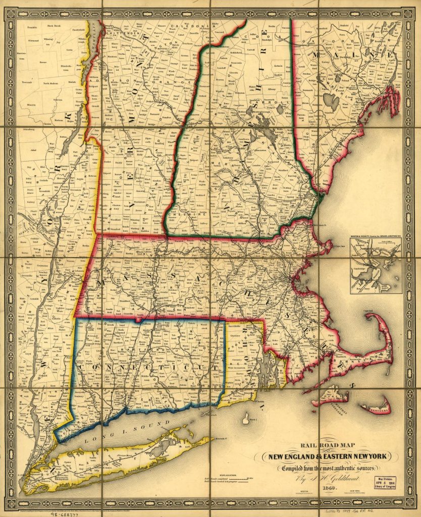
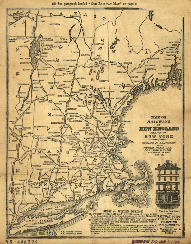
Other American Maps that can be used to provide comparisons with Zimmermann’s map are mentioned below. Distunell’s map, however, is a excellent map to utilize since it portrays road, rail and waterways.:

Historic Railroad Map Of The Northeastern United States – 1853 https://www.worldmapsonline.com/historic-railroad-map-of-the-northeastern-united-states-1853

Goldthwait, J. H., Railroad map of New England & eastern New York complied from the most authentic sources, Boston : Redding & Co. ; New York : Clark, Austin & Co., 1849, Library of Congress, Library of Congress Control Number 98688377, https://lccn.loc.gov/98688377

Snow & Wilder, Hitchcock, DeWitt C., Map of railways in New England and part of New York; Boston, [1847] engraved by D. C. Hitchcock for the Pathfinder Railway Guide, Library of Congress Control Number 98688376, Library of Congress, https://lccn.loc.gov/98688376

[36] Rudolph Vecoli, European Americans: From Immigrants to Ethnics, Section I : Immigrants, Ethnics, Americans, Cleveland Ethnic Heritage Studies, Press Books, Cleveland State University 1976. https://pressbooks.ulib.csuohio.edu/ethnicity/chapter/european-americans-from-immigrants-to-ethnics/

James Boyd in his Introduction to his PhD Dissertation , The Limits to Structural Explanation, provides a good overview of the historical approaches that have been used for explaining German migration to America, see: 

James D. Boyd, An Investigation into the Structural Causes of German-American Mass Migration in the Nineteenth Century, Submitted for the award of PhD, History, Cardiff University 2013, https://orca.cardiff.ac.uk/id/eprint/47612/1/2013boydjdphd.pdf

Helbich, Wolfgang. “German Research on German Migration to the United States.” Amerikastudien / American Studies, vol. 54, no. 3, 2009, pp. 383–404. JSTORhttp://www.jstor.org/stable/41158447

Günter Moltmann, “Migrations from Germany to North America: New Perspectives.” Reviews in American History, vol. 14, no. 4, 1986, pp. 580–96. JSTORhttps://doi.org/10.2307/2702202

Marianne S. Wokeck, Trade in Strangers: The Beginnings of Mass Migration to North America, University Park: Pennsylvania State University Press, 1999

Häberlein, Mark. “German Migrants in Colonial Pennsylvania: Resources, Opportunities, and Experience.” The William and Mary Quarterly, vol. 50, no. 3, 1993, pp. 555–74. JSTORhttps://doi.org/10.2307/2947366

Philip Otterness, Becoming German, The 1709 Palatine Migration to New York, Ithaca: Cornell University Press, 2004

Donna Merwick, Possessing Albany, 1630-1710: The Dutch and English Experiences, Cambridge, 1990

Thomas Burke, Mohawk Frontier: The Dutch Community of Schenectady, New York 1660-1710, Ithaca, 1991, Page 213

Natalie Zemon Dennis, Cultivating a Landscape of Peace: Iroquois-European Encounters in the Seventeenth-century America, Ithaca, 1993

Francis Jennings, Ambiguous Iroquois Empire, New York, 1984

The Palatine Germans, The National Park Service, Updated October 8, 2022 https://www.nps.gov/articles/000/the-palatine-germans.htm

Aaron Spencer Fogleman, Hopeful Journeys: German Immigration, Settlement and Political Culture in Colonial America, 1717-1775, Philadelphia: University of pennsylvania Press 1996

Philip Otterness, Becoming German, The 1709 Palatine Migration to New York,Ithaca: Cornell University Press, 2004

Cobb, Sanford Hoadley. The Story of the Palatines: An Episode in Colonial History. United Kingdom, G. P. Putnam’s sons, 1897. https://www.google.com/books/edition/The_Story_of_the_Palatines/eUgjAAAAMAAJ?hl=en

Brink, Benjamin Myer. “The Palatine Settlements” Proceedings of the New York State Historical Association, vol. 11, 1912, pp. 136–43. JSTOR, http://www.jstor.org/stable/42889955. Accessed 27 May 2023.

Ellsworth, Wolcott Webster. “The Palatines in the Mohawk Valley.” Proceedings of the New York State Historical Association, vol. 14, 1915, pp. 295–311. JSTOR, http://www.jstor.org/stable/42890044. Accessed 27 May 2023.

Diefendorf, Mary Riggs. The Historic Mohawk. United Kingdom, Putnam, 1910. https://www.google.com/books/edition/The_Historic_Mohawk/ziIVAAAAYAAJ?hl=en

Benton, Nathaniel Soley. A History of Herkimer County: Including the Upper Mohawk Valley, from the Earliest Period to the Present Time ; with a Brief Notice of the Iroquois Indians, the Early German Tribes, the Palatine Immigrations Into the Colony of New York, and Biographical Sketches of the Palatine Families, the Patentees of Burnetsfield in the Year 1725 ; and Also Biographical Notices of the Most Prominent Public Men of the County ; with Important Statistical Information. United States, J. Munsell, 1856. https://www.google.com/books/edition/A_History_of_Herkimer_County/G1IOAAAAIAAJ?hl=en

[37] Burnett and Ken Luebbering, German Settlement in Missouri: New Land, Old Ways, Columbia: University of Missouri Press, 1996

[38] Hungerford, Edward. “Early railroads of New York” New York History, vol. 13, no. 1, 1932, pp. 75–89. JSTOR, http://www.jstor.org/stable/24469729 

Ellis, David Maldwyn, “Rivalry between the New York central and the Erie Canal” New York History, vol. 29, no. 3, 1948, pp. 268–300. JSTOR, http://www.jstor.org/stable/43460288 

Rapp, Marvin A., “New York’s Trade on the Great Lakes, 1800 -1840.” New York History, vol. 39, no. 1, 1958, pp. 22–33. JSTOR, http://www.jstor.org/stable/23153562 

Fairlie, John A. “The New York Canals.” The Quarterly Journal of Economics, vol. 14, no. 2, 1900, pp. 212–39. JSTOR, https://doi.org/10.2307/1883769 

North, Edward P. “The Erie Canal and Transportation.” The North American Review, vol. 170, no. 518, 1900, pp. 121–33. JSTOR, http://www.jstor.org/stable/25104942 

Whitford, Noble E. “Effects of the Erie Canal on New York History.” The Quarterly Journal of the New York State Historical Association, vol. 7, no. 2, 1926, pp. 84–95. JSTOR, http://www.jstor.org/stable/43566182 

Jackson, Harry F., “The Erie Canal.” Scholar in the Wilderness: Francis Adrian Van Der Kemp, Syracuse University Press, 1963, pp. 268–82. JSTOR, https://doi.org/10.2307/j.ctv64h7kc.25 

Shaw, Ronald E. “Canals in the Early Republic: A Review of Recent Literature.” Journal of the Early Republic, vol. 4, no. 2, 1984, pp. 117–42. JSTOR, https://doi.org/10.2307/3122718

Burd, Camden. “A New, Historic Canal: The Making of an Erie Canal Heritage Landscape.” IA. The Journal of the Society for Industrial Archeology, vol. 42, no. 2, 2016, pp. 23–34. JSTOR, https://www.jstor.org/stable/26643089

[39] Gerlach, Russel, The German Presence in the Ozarks, OzarksWatch, Vol III, No.1, Summer 1989, https://thelibrary.org/lochist/periodicals/ozarkswatch/ow301h.htm Page, Thomas W. “The Transportation of Immigrants and Reception Arrangements in the Nineteenth Century.” Journal of Political Economy, vol. 19, no. 9, 1911, pp. 736. JSTORhttp://www.jstor.org/stable/1820349 .

Reinhard Wittmann, Ein Verlag und seine Geschichte: Dreihundert Jahre J. B. Metzler Stuttgart (Stuttgart: J. B. Metzlersche Verlagsbuchhandlung, 1982), 411. 

Dolindel, Sonja, , Off to New York ! A story of immigration in the 19th century in pictures, 16.12.2021, Kultur und Wissen online, Deutsche Digitale Bibliothek, https://www.deutsche-digitale-bibliothek.de/content/blog/ab-nach-new-york-eine-geschichte-der-auswanderung-im-19-jahrhundert-bildern?lang=en

Zimmermann, Gotthelf. Auswanderer-Karte und Wegweiser nach Nordamerika. Stuttgart: J.B. Metzler’schen Buchh, 1853. Map. https://www.loc.gov/item/98687132/ 

[40] Dahmann, Donald C., Presenting the Nation’s Cultural Geography, General Maps Collection, Articles and Essays, Nationals Atlases. Library of Congress, https://web.archive.org/web/20201109045038/https://www.loc.gov/collections/general-maps/articles-and-essays/national-atlases/presenting-the-nations-cultural-georgraphy/

[41] Ibid, Dahmann, Donald C., Presenting the Nation’s Cultural Geography

[42] A. de Witzleben, German Population 9th Census, Page 325, in Francis A Walker, Superintendent of Census, Ninth census – Volume I,  The Statistics of the Population of the United States, Washington, Government Printing Office, 1872 https://www.google.com/books/edition/Ninth_Census_volumes/0ngZm56S-7sC?hl=en&gbpv=1

For a 1890 version, see: Gannett, Henry, 50. Density of Distribution of the Natives of the Germanic Nations, Plate 20, Statistical atlas of the United States, based upon the results of the eleventh census, United States. Census office. 11th census, 1890 https://www.loc.gov/resource/g3701gm.gct00010/?sp=40

[43] The “German belt” refers to the region of the United States where large numbers of German immigrants settled in the 19th century, especially from the 1840s to early 1900s. This area stretched from Pennsylvania across the Midwest to the Great Plains states. It included states like Pennsylvania, Ohio, Indiana, Illinois, Wisconsin, Minnesota, Iowa, Missouri, Nebraska, Kansas, and parts of the Dakotas. The highest concentrations were in the Upper Midwest.

[44] Midwestern United States, Wikipedia, This page was last edited on 15 May 2024, https://en.wikipedia.org/wiki/Midwestern_United_States

[45] Kamphoefner, Walter, The German Component to American Industrialization, Jan 27, 2014, Immigrant Entrepreneurship: 1720 to the Present, , German Historical Institute, http://www.immigrantentrepreneurship.org/entries/the-german-component-to-american-industrialization/

Bergquist, James M. “German Communities in American Cities: An Interpretation of the Nineteenth-Century Experience.” Journal of American Ethnic History, vol. 4, no. 1, 1984, pp. 9–30. JSTOR, http://www.jstor.org/stable/27500350

[46] Schulten, Susan ,A History of America in 100 Maps, Chicago: The University of Chicago Press, 2018, Page 8

Our German Descendants from Baden: A Tradition of Migration (Part Two)

This is part two of a story that focuses on the possible historical influences on German immigration from the Baden area in the mid 1800s. The second part of the story discusses the following influences:

  • Travel Agents & Brokers: the influence of travel agents on facilitating travel; and
  • Travel literature: the information contained in emigration maps, newspaper, and books as a reflection of accumulated knowledge of migration.

It is not known if John Speber or the Fliegel family used Travel agents or brokers or travel literature to plan their journeys to America. It is likely that they used brokers to secure passage on packet ships to New York.

As stated in the first part of this story, Germans from Baden, specifically in the geographical areas where John Sperber and the Fliegel family were from, had a long tradition of migrating to America. Their route getting to America was different from the Baden emigrants in the 1700s and early 1800s. However, there may have been a strong likelihood that they followed the guidance from past generations from their communities to settle in New York state. Even without specific contacts, they may had at least a general idea of settling in the ‘Palatine area’ of New York state. The use of travel agents or brokers may have been a means to make the journey happen.

As Competition Increased, Greater Enterprise Proved Needful

“The emigrant agent was not a new creation. In the previous century he had appeared as a traffiker in the souls, the Seelenverkaufer, who visited village after village on the upper Rhine and with his siren songs and promises filled Dutch ships with repdemptioners. In the nineteenth century he acted as the intermediary … . “ [1]

Midway through the eighteenth century, competition for the emigrant trade intensified. The role of a shipping agent became specialized and the migrant broker evolved as a new role and focused on utilizing various strategies to attract migrants. The contacts that informed the migrant brokers about the supply of migrants in the hinterland consisted primarily of boatmen working on the Rhine waterway system. The boatmen served as go-betweens on a commission basis. They were joined by an expanding network of inland agents who solicited migrants.

Another role that emerged was the “Newlander” (neuländer). The newlanders were former German emigrants who travelled back home and worked for American land speculators and employers who were aware of their ability to influence chain-migration patterns. [2]

There was a shift in the nature of German immigration with the demise of indentured servitude to America after 1819. Post 1819, German migrants now paid for their passage. Consequently, the cost of travel to the United States became a key determinator to emigrate. Cost also was a major factor concerning what port to embark and where to end up in America. Passenger transportation became an important branch of commerce and a source of competition among shipping companies and between major ports. [3]

“At first the scramble for passengers centered in the ports but as competition increased, greater enterprise proved needful.”[4]

With to the advent of packet ships, standardized ship schedules, and a shift to other ports starting in the in 1820s and 1830s, travel agents and brokers started playing a role in facilitating German immigration to the United States. Their role was notable when the overland and overseas journey from Europe was a longer, more arduous, and a multi-stage process. [5]

“The Atlantic migration on which these individuals now embarked … was conducted by different models and networks than in the previous century. German migrants now paid their passage … the majority departed from ports such as Le havre, Bremen, Liverpool, and latterly Hamburg.” [6]

Initially the captain of a ship negotiated passage on the voyage. Newspaper advertisements typically advised “Apply to the Captain on board“. By the 1830s, the role of a ship broker emerged. Initially the role amounted to being a ‘runner’ that brought passengers to the captain of a ship and received a commission for the number of passengers brought for transport. This role changed and expanded when the owner of a ship, which could have been the captain, sold the available passenger space for a flat sum to a recruiting house. [7]

It was customary for the captain to lease to an emigrant agent the space reserved for passengers, and to assume no responsibility himself for their comfort and well-being.[8]

The Role of Travel Agents

The role of travel agents in the German immigration to the United States was multifaceted and evolved, reflecting broader changes in transportation, regulation, and the nature of migration itself.

In the early stages of German immigration, particularly during the nineteenth century, travel agents, also known as “Makler” in Germany and “runners” in the United States, played a role in facilitating the journey of German emigrants to America. These agents were part of a larger network of individuals and organizations that helped emigrants navigate the complexities of international travel, from their departure in German ports to their arrival and settlement in the United States. [9]

Travel agents played several facilitating roles in German immigration to the United States in the 1830s through 1850s:

  1. Facilitating Travel: As a primary role, travel agents and companies provided services that helped immigrants navigate the logistics of transatlantic travel, which included arranging passage on ships and providing information on the travel process. [10]
  2. Promotion and Information: Travel agents and emigrant aid companies actively promoted travel to the United States through advertisements, pamphlets, guidebooks, and newspapers designed for emigrants. They distributed materials that highlighted the benefits of emigration and provided practical advice for the journey. [11]
  3. Political Influence: In specific geographical areas and contexts, German immigrants were specifically recruited. For example, German immigrants were specifically recruited by the state Wisconsin in the 1850s, . Another example is the Mainzer Adelsverein at Biebrich am Rhein, better known as the Mainzer Adelsverein (“Nobility Society of Mainz”) which was a colonial attempt to establish a new German settlement within the borders of Texas. Recruitment advertisements and publications were written and used to appeal to German immigrants, as exemplied by the writing of Eduard Pelz, reflecting the political motivations behind encouraging certain groups to emigrate to certain areas. [12]
  4. Protecting Immigrants: Some organizations, like the Deutsche Gesellschaft von New Orleans, were initially established to protect German immigrants from false agents and travel brokers. They also provided advice on avoiding disease and helped immigrants make arrangements to settle in “healthy” areas, away from regions prone to yellow fever. Benevolent organizations were formed in Philadelphia, New York City, Boston, and Galveston during the early to mid 1800s. They maintained employment agencies for common laborers, furnished credit to establish artisans in their trade, provided services for women, procured legal advice, provided aid to German immigrants in port cities, and medical aid. [13]

The Influence of Travel Brokers and Travel Agents in the 1840’s and 1850’s

It has been argued that the ‘push’ factors of the local and regional German economy and social structural factors of the local communities and the ‘pull’ factors of economic opportunity and information from family and friends contained in emigrant letters were the more decisive for formulating decisions to emigrate than the influence of travel brokers or travel agents. Combined with local knowledge of past migratory practices and correspondence from family or community members living in America, the use of travel brokers possibly helped emigrants with the completing the details of journey that was already planned. [14]

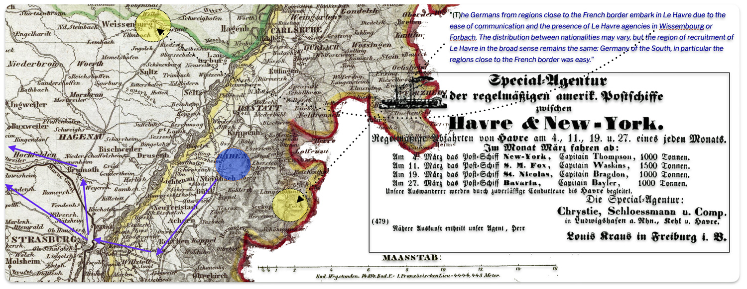
The agent’s or broker’s role was, for practical purposes, limited to facilitating the travel. They guaranteed that the price of a ticket would not increase while the emigrant was traveling to the port. They also assured space on board as well as setting any unplanned events associated with irregular sailing schedules. If travel agents or travel brokers had any influence, it may have been convincing migrants to leave from a particular port and consequently increasing the use of a particular port.

(A)gents should be seen as mediators and facilitators, who eased the process of emigration. But they could do little to promote it where a predisposition did not already exist or a firm decision to emigrate had not already been made.” [15]

As competition for European emigrants increased between the European ports, individual companies, cities and states implemented regulations and practices to garner an edge or a larger share of emigrants to their respective ports. At first the scramble for passengers centered on the ports but as competition increased, travel agents utilized by the shipping companies and the respective city governments gained more prominence.

“By 1846-7, a network of fast interior travel routes, and an abundance of embarkation ports – all with agents vying for emigrant cargo – were in place. Agents were no longer unscrupulous figures known by previous generations; in Baden, Württemberg and Hessen, they were licensed, bonded and kept under surveillance, with contracts legally obligated to guarantee that passengers would reach their stipulated destination at the agreed price.” [16]

“Agents appear somewhat more frequently in immigrant letters than do guidebooks or emigration societies, but primarily as facilitators, not as promoters of emigration. Potential followers were often advised as to the dependability of a particular agent. Negative experiences were just as readily reported as positive ones.” [17]

The reliability and assurances in the advertising or travel brokers and agents were corroborated or questioned as German immigrants wrote back to relatives and friends in Germany.

As immigration increased in volume, passenger transportation became a more important branch of the shipping business between Europe and America, and rivalry among the ship-owners grew keen. It was necessary for them to advertise abroad through publications and traveling agents not only the free institutions and bounties of nature in America, but also the special facilities they offered for crossing the ocean. Meantime it grew easier to detect misrepresentation. The postal service became better and cheaper on both sides of the Atlantic, and other means of communication were improved. In consequence the ill-usage or discomfort of passengers on certain ships became known to prospective emigrants, and the reputation and profits of the owners suffered.[18]

The Port of Le Havre and Travel Brokers

Due to it increased dominance in international commerce and transportation of emigrants, Le Havre experienced rapid and dramatic population growth during the mid-nineteenth century. A city of fewer than 27,000 inhabitants in 1823, it doubled in size by 1846. It was a port city of extreme wealth and poverty. [19]

“As in Paris, the sudden pressure exerted by this growth on the city’s physical and social structures caused considerable anxiety among political leaders. The concentration of so many people in the close quarters of the central city—especially working people confronting the contradictions of dire poverty in the midst of great mercantile and industrial wealth—gave a troubling immediacy to the prospect of disease and unrest; on the heels of two cholera epidemics and two revolutions in France during the 1830s and 1840s, few could ignore the threat posed by the nation’s increasingly pathological cities. A perceived penchant for drink and depravity among the “dangerous classes” only exacerbated the fears of local and national elites.” [20]

The following advertisement reflects the practices of immigrant agents from Havre. The advertisement indicates that emigrants are accompanied to Havre by licensed agents, suggesting travel agents were meeting prospective emigrants outside of Havre. Fair warning was also given to prospective emigrants about verifying their good standing.

1855 Advertisement – Parket Ship Service from Le Havre

Click for Larger View | Original source not known. Secondary source: Rosen, Mark, Genealogish – historischer Service, Packet service to New York in 1855, Le Havre as emigration port (Part 1: 1817 – 1860),  http://www.genhist.org/ghs_Havre_eng.htm

Translation of the Advertisement

The port began to function as an emigration port at the end of the Napoleonic wars around 1815. Boarding passengers was a by-product of commercial shipments. As ship travel gained importance not only for commercial commerce but also for immigration, the docks at Le Havre were enlarged to accommodate the increased steamboat traffic from local ports. A German colony of innkeepers, shopkeepers and brokers subsequently developed to service the emigrant needs at the port. [21]

“The combined influence of the cotton and emigrant trade drew to it not only representatives of the larger commercial houses, but also a host of German innkeepers, small merchants and ship agents. The emigrants themselves sometimes went no further. … Every season left some to live upon the charity of the French, or to find a way back to their former home.” [22]

Given the impact of large groups of emigrants waiting for departing boats on the local infrastructure of the city and to avert having indigent emigrants showing up in the city, travel agents from Le Havre began meeting emigrants on the road from Strasbourg to sign them up in advance for passage to facilitate the emigration process. After 1837, when the French government required Germans to present a valid ticket at the border, local offices opened in Switzerland and the German states to facilitate this process. [23]

A French researcher points out the influence of Le Havre travel agencies located in Wissembourg, France and Forach, Baden on facilitating German immigration travel from Havre. (The following is a rough translation from French).

“(T)he Germans from regions close to the French border embark in Le Havre due to the ease of communication and the presence of Le Havre agencies in Wissembourg or Forbach. The distribution between nationalities may vary, but the region of recruitment of Le Havre in the broad sense remains the same: Germany of the South, in particular the regions close to the French border was easy. The Badens were the most numerous in 1856 and the years following, while the number of Bavarians, the most important previous years, tends to decrease.[24]

Map One: Proximity of Havre Travel Agencies to BadenBaden [25]

Map one is a depiction of Baden in 1846. As such it shows major roads, rail lines and waterways that existed in the mid 1840s. The above mentioned Havre travel agent locations were on water tributaries. They may have been minor roads that mirrored the tributaries that led to Baden-Baden where John Sperber lived. The map indicates the location of Weissenburg (or Weissenbourg) and Forbach (in the map it is noted as ‘Forb’. The distance between Weissenburg and Baden is about 50 kilometers or 31 miles. The distance between Baden and Forbach is about 20 kilometers or about 19 miles.

Travel Agents and the Hanseatic Cities of Bremen and Hamburg

In the late 1830’s, the city of Bremen “caused the employment of several hundred local representatives. Not only did these agents attend to the mechanics of emigration, but they stimulated the movement to their own private gain, printing letters in the newspapers, distributing circulars and conversing in the public houses and market places.” [26]

German emigres utilizing the port of Liverpool via Hamburg were assisted by German speaking travel agents. The “Hull Route” to America, involved immigrants departing from Hamburg, Germany to Hull, England and then departing from Liverpool. The route purportedly offered a saving in time and money. “At Hamburg, (travel) agencies sold the necessary tickets, and at Hull German guides who spoke English met the parties and conducted them across the island to the waiting sips at Liverpool.” [27]

The migrant became the commodity around which the shipping industry developed. Aware of the geographic disadvantages, the merchant community made a great effort to establish networks of migrant agents to divert the flow to Bremen. [28]

The following poster 1851 poster from the Bremen Information and Referral Agency provides information on accommodations, licenses forwarded or brokers, information on prices and debarkation ports and contact information to report complaints about unsatisfactory treatment. [29]

Poster of the Bremen Information and Referral Agency, 1851

A rough translation for the top portion of the poster: Notice for protection and care for Emigrants staying in Bremen, officially confirmed by the Senate Protection Bureau 

The German governments, notably the Hanseatic city-states of Hamburg and Bremen, understood the importance of travel agents but also developed protective measures on behalf of emigrants through the supervision of travel and the licensing of agents. Certain practices, such as the sale of ‘through tickets’ into the interior of the United States were prohibited. The cities demanded a substantial bond payment as a guarantee against default of providing available slots for travel. [30]

“To wean migrants from the established Rhine route, one of the broker-officials in 1831 founded an agency in Frankfurt to (1) sell tickets for the trip from the place of origin to the American port of debarkation, (2) organize the trip to Bremen, (3) guarantee a berth on a ship-which were usually not yet departing in regularly scheduled line traffic. By 1832, about a dozen such agencies operated in central and southern Germany, with subagents in smaller places and with assistants along the route to Bremen who helped the emigrants along.” [31]

In 1854, several Bremen agencies in south-eastern Germany organized a joint “travel agency” in Cologne which took care of the migrants’ trip from the home villages along the Rhine and inland tributaries to Bremen. [32]

The public and private sectors in the city of Bremen worked together to establish protective measures for the emigrant and an environment to facilitate private initiatives to stimulate and profit from emigration. 

“After 1850 for the accommodation of emigrants passing through she (Bremen) maintained a bureau of information; and special agents appointed by the city authorities met the incoming trains at the railway stations, guided them to hotels that had been inspected and licensed to receive them, protected them against extortion, and gave them aid and advice in preparing for the voyage. All these measures were quickly adopted by Hamburg, and some of them appeared in the passenger acts of Holland in 1837, of Belgium in 1843, and of France in 1855.” [33]

Literacy and Education in the Duchy of Baden and German States

It is not known what education levels John Sperber and the Fliegel family members attained when they were growing up in Baden. It is also not known what impact, if any, information gleaned from local newspapers and advertisements had on their plans to immigrate to America. It is assumed that they had a minimum of four years or more years of education and, thus, were able to read available newspapers and literature on America. They were from small villages or towns in central and northern Baden.

We can place our relatives from Baden Germany in an historical context with regard to literacy levels in the Grand Duchy of Baden and other German confederation states at the time of their life prior to emigrating. An historical understanding of the state of newspapers in the Grand Duchy of Baden can also provide sense of the relative importance and possible influence newspapers and newspaper advertisements may have had on emigration.

In the last third of the nineteenth century Germans became a “paper-reading people.” [34] While this observation references the reading habits of Germans after John Sperber and the members of the Fliegel family had emigrated from Baden, the education levels and literacy rates of common Germans in the nineteenth century were quite high, especially compared to other European countries at the time.

From 1450 to 1550, literacy rates in Germany climbed from 7 percent to around 16 percent. Over the next century the number of literate adults doubled in Germany, and remained at this level until the early nineteenth century. From 1820 onwards, literacy rates incrementally increased to 99%. [35]

By 1850, Prussia’s literacy rate had reached 85%, which was representative of the rest of the German states. This compares to a mid-century literacy rate of 61% for France (reading only) and 52% for England (reading and writing). [36]

In the early nineteenth century, Baden was among the first German states to introduce free and generally compulsory primary education, consisting of an eight-year course called Volksschule (elementary school). This provided basic skills like reading, writing, and arithmetic, along with a strict education in ethics, discipline and obedience to the state. In 1810, Baden introduced state certification requirements for teachers, which significantly raised the standard of teaching. [37]

It is notable that an organizational edict was issued in Baden in 1803 to reorganize and standardize the states’s educational system. The edict made elementary schooling compulsory and promoted academic freedom at the university level. It was part of Baden’s state-building efforts after Baden’s territorial expansion. [38]

Key points about the “Thirteenth and Last Organizational Edict of May 1803”  are:

  1. It aimed to organize the common and scientific educational establishments in Baden’s newly united territories, considering the variety of existing institutions in the geographical area and the addition of Heidelberg University.
  2. The edict divided schools into rural and urban elementary schools. Rural schools were to provide basic Christian and civic knowledge to students without distracting them from their occupational work. (C)lasses are held early enough for the older children so that
    a good part of the day remains during which they can help their parents with domestic work.”
  3. It mandated permanent year-round schools rather than just winter schools, so children would not forget their learning over the summer.
  4. School attendance was compulsory from ages 7 to 13 for girls and 14 for boys, with punishments for willful absences. School supervisors were required to “punish the children if their willfulness is to blame or the parents if they have given cause to the children for this conduct. Punishment of the former involves moderate beating, of the latter, sentencing to minor fines, either from 12 to a maximum of 60 kreuzers to the local alms, or by imprisonment in the village hall for a duration of four to 24 hours.”
  5. Subjects of instruction in rural elementary schools must be: spelling, reading, writing of the German language, arithmetic, singing, Bible history, materials of religious instruction, “(among which we count primarily that which must be committed to memory.)”
  6. In addition to the basic elementary school, it was instructed that ‘finishing schools’ that existing in various regions of the country should be standardized.
  7. The edict standardized various named higher level schools and their curriculum that existed in different areas of Baden under the rubric of Lycei schools.
  8. The edict was seen as a departure from the medieval tradition of education as a tool of the state. Instead, it promoted the modern concept of freedom in research and instruction. [39] [Click for PDF Copy]

“(G)irls and boys attended elementary school together, and the high literacy rate suggests that schools were well attended. Textbooks for schools in Baden during the late nineteenth century offered extensive information on the geography, population, and life in the United States to a broad readership of young Badeners.” [40]

Baden was part of the German states that saw literacy rates substantially higher than other parts of Europe by the mid-nineteenth century. The literacy gap between the Netherlands and West Germany ranged from 70% in 1600 to 15% in 1800, with West German towns catching up to Dutch literacy rates by the 18th century. [41] The combination of early compulsory education laws, cultural emphasis on literacy in the German states, and development of school infrastructure likely drove Baden’s high literacy rate compared to other regions by 1850.

The expansion of compulsory primary schooling mirrored the rise in literacy rates in Baden. Literacy rates rose dramatically, from around 80% in the early 1800s to near universal literacy by 1900.

“By the 1840s Baden had achieved a recognized statehood, not only among the powers of Europe, but more importantly among its own citizens. Economic development, an expanded educational system, the stirring of free trade and the state financing of railroads are, along with a vital constitutional system and political life, the most important indications of state-building. Other signs that diverse societies were merging into one unity of state and society include a literature of atlases, travelogues, handbooks, and newspapers intended for a Baden audience.” [42]

Newspapers in Germany in the 1830s – 1850s

Most of the newspapers in the German states in this time period catered to localized regions within their respective state boundaries. There were a few notable German newspapers that had a following in other states and European countries. In addition, there were a few influential newspapers from France and other countries that were read in the German states.

“In 1830, the main British and French daily newspapers, such as the Times and the Moniteur, were read throughout Europe, after their distribution network had spread through large parts of the continent in the 18th century. To a lesser extent, the most influential German-language daily, the Allgemeine Zeitung of the Tübingen publisher Johann Friedrich Cotta established in 1798, also had a European readership. … In addition to full-time editors, the most influential newspapers also engaged a dense network of journalists and correspondents, who sent in regular news and reports.” [43]

There existed about 100 political newspapers in Germany before 1848. German political and social realities were not favorable to the growth of a modern press in the first half of the 1800s. The political fragmentation among 39 German states impacted communication and transportation. This had implications on the development, range, and impact of German newspapers on their potential audience. The backwardness of the postal system in the German confederacy between 1830 – 1850 had not yet been incorporated into the Prussian-led customs union, the Zollverein. This made the distribution of a newspaper a financially prohibitive venture. [44]

“For instance, in 1840 the Seebliitter (a newspaper in Konstanz, Baden) cost 1 Gulden 30 Kreuzer biannually in Konstanz, but 2 Gulden 20 Kreuzer anywhere else in Baden. Its price doubled upon entry into a neighboring state, and cost increases of 500 to 600 percent were not uncommon when several state borders had to be crossed. If a certain newspaper staff aspired to conquer a national market, it had to gear its product to the wealthy class of Germans … . [45]

Coupled with the challenges of the cost and ability to create a circulation base wider than a city or local region, there was the effects of Vorzensur during this time period on what was published in German newspapers. Vorzensur is the German term for “prior restraint” or “pre-censorship”. It refers to ‘censorship imposed, usually by a government or institution, on expression before publication or distribution, prohibiting particular instances of expression‘. [46]. Vorzensur (pre-publication censorship) existed in the German Confederation during the Vormärz period in the early-to-mid 1800s, a period that John Sperber and the Fliegel family lived in the Grand Duchy of Baden. [47]

“The publishers owed their existence to the sale of their papers; and what sold then, as what sells today, were those papers that pleased the public. They saw no advantage in jeopardizing a sure thing by opting for two unpredictables: the financial uncertain ties of enlarging a market and the challenge of censor ship.” [48]

It was a time of growing social and political tensions after the Congress of Vienna in 1815 re-established the old monarchical order with new state governance structure in the German Confederation. The period was characterized by political conflict between ‘restorationist forces’ led by primarily by Austria, one of the two ‘powerhouse’ states in the confederation (the other being Prussia), and liberal nationalist movements within many of the medium-sized states (like the Duchy of Baden) and smaller states of the confederation. Political factions in the latter mentioned group wanted a unified German nation-state with a constitution and individual rights.

To suppress liberal and nationalist sentiments, Metternich, the leader from the dominant confederation state of Austria, instituted the repressive Carlsbad Decrees in 1819, establishing strict censorship and surveillance. Despite this, liberal and nationalist ideas continued to spread, especially among the rising educated middle class (Bürgertum), student fraternities (Burschenschaften), cultural societies, and the rising professional class of state bureaucrats.

“The ambivalence toward Vormarz censorship was nowhere more apparent than in Baden, which at that particular time was the constitutionally most advanced state in Germany. Freedom of the press being an expected pillar of a democratically oriented government, the Badensean authorities found themselves in a dilemma trying to reconcile the demands of the Iiberals for freedom of the press with the controls over it expected by the Bund (German Confederation – Deutscher Bund). Its press legislation, as well as its censorship enforcement, reflected this situation.” [49]

“For instance, the state of Baden silenced the dangerous Deutsche Volkshalle of Konstanz, which in 1840 already pursued a strictly republican tendency, by having the Konstanz post office confiscate a whole series of issues within the span of two months.” [50]

Emigration Advertising and Newspapers

Within the strictures of Vorzensur [51] , German-language newspapers both in Germany and the United States played a role in the mid-1800s in spreading information about emigration opportunities, providing practical advice to emigrants, and helping maintain connections and identity within German immigrant communities. [52]

“The average German of that time was content in thinking no further than the limits of his township. This parochial view clearly influenced the content and the format of the majority of papers … . “ [53]

Various advertisements in German newspapers and in books gave information about where to stay in specific continental ports, the cost of staying in the ports while waiting for outgoing ships, the costs of travel from major ports to America, and how to survive cheaply before setting sail. Newspaper and books also provided personal experiences from German immigrants who settled in America.

One notable example of the influence of newspaper reporting on the German emigrant experience in the mid 1800s is the German newspaper Allgemeine Auswanderungs-Zeitung. It was printed by the Rudolstadt publisher Günther Fröbel between 1846 and 1871, during times of high demand for emigration information. A major distinction of this newspaper was its sole focus on German emigration and related subjects, .

The newspaper aimed to inform readers about the realities of emigration and life abroad. Not only did it provide descriptive facts and costs associated with travel, it kept readers abreast of emigration-related news and debates. The newspaper included passenger lists and information for emigrants from 1848-1869. It reprinted articles from other papers like the American German newspaper Anzeiger des Westens [54] about emigrant experiences. The paper reported on controversial issues such as the return migration experiences to Germany in the mid-1800s. [55]

Masthead of Allgemeine Auswanderungs-Zeitung [56]

“ln Germany, in 1846, Günther Fröbel, a printer, publisher. and emigration agent, began publishing one of the main emigration newspapers, the Allgemeine Auswanderungs-Zeitung ( AAZ: General Emigration Newpaper). Though he published this newspaper out of the city of Rudolstadl, an interior city located in the current German state of Thuringia, roughly 250 kilometers east of Frankfurt. Fröbel was known as a well-informed emigrant agent. Throughout iitsi 26 years of circulation. the AAZ provided advice, lists of ships that were traveling overseas, articles on emigrants’ experiences, information on what to expect at different destinations, and reporting on all sorts of regions around the world in which Germans were settling. Regular readers of this newspaper were primarily people involved in the business, of migration including agents, shipping. brokers, business people, and government authorities.” [57]

Bremen, one of the ‘big three’ ports of departure in the 1840s- 1850s also had a major newspaper that principally reported on emigration and immigration matters in the mid 1800s – the Deutsche Auswanderer-Seitung (German Emigrant Newspaper). The Deutsche Auswanderer-Zeitung was founded in 1852 by Carl Schünemann, a Bremen publisher and bookseller. Schünemann recognized the need for a newspaper that could provide reliable information and advice for the many Germans considering emigration in the mid-19th century. He used his publishing house, C. Schünemann Verlag, to print and distribute the weekly newspaper.

The Deutsche Auswanderer-Zeitung was primarily read by Germans who were considering or planning emigration, particularly to the United States, during the mid-19th century. While the exact circulation figures are not readily available, the newspaper’s longevity (1852-1875) suggests that it had a significant and stable readership during its years of publication. 

The “Deutsche Auswanderer-Zeitung” was published weekly. This frequency allowed it to provide timely and relevant information to its readers, who were primarily individuals and families planning to emigrate or already in the process of emigrating. The weekly publication schedule helped keep the German emigrant community well-informed about the latest news, legal changes, and opportunities available in their new homelands. [58]

Masthead of the Deutsche Auswanderer-Seitung [59]

“Reading through … emigration newspapers is a bit like bearing witness to the development of an expanding business and activity, namely the transportation of people east to west and/or south. In 1846, the first year of publication, regular and consistent passenger service from the European continent was still not quite established, and the AAZ (AAZ stands for Allgemeine Zeitung) newspaper explained that captains needed to fill their empty ships with passengers. By 1847, there were many ads showing that regular service had been established. In 1850, there was a noticeable uptick in the number of advertisements announcing regularly scheduled sailings between Europe and the United States. At this point, there were also more ads claiming passage on “fast” sailing ships, presumably trying to compete with the new steamships. Over the 1850s, more and more ads were placed regarding passage on steamships. By 1855, advertisements for fares on sailing ships dropped off and the paper no longer printed a fare table.” [60]

German Books and Auswander Publications

German newspapers and books circulated letters from German immigrants, describing their experiences and the prospects in America. Books were also published that provided descriptions of American life and opportunities.

Traugott Bromme’s “Handbook and Travel Book for Emigrants” [61]

Guidebooks specifically for German emigrants, such as Traugott Bromme’s “Handbook and Travel Book for Emigrants”, initially published in 1840, and appeared in several editions between 1840 and 1866 were popular.  [62]

“The 1848 edition contains over 550 pages divided into two main parts. In the first part, Bromme offered a general overview of the United States, including thumbnail sketches of most of the states, territories, or countries that an emigrant might enter in North America.” [63]

In 1842, Bromme published a two-volume set Gemälde von Nord-Amerika (Portrait of North America) intended as both a travel guide and “entertaining instruction”. [64]

“Traugott Bromme sought to further German immigration to the United States both as a public advocate and as an entrepreneurial author and book seller. Realizing that there was a market for guides that German immigrants could use to help orient themselves in their adopted land, he leveraged the first-hand knowledge that he had acquired living and traveling throughout North America, and his general knowledge of the region acquired through other sources, to provide a valuable service to Germans … .” [65]

An earlier book that was popular was an 1829 book by Gottfried Duden. Duden had an influence on German immigration to the United States, particularly to the state of Missouri, in the early-to-mid 19th century. His famous 1829 book, “Report on a Journey to the Western States of North America” (German: “Bericht über eine Reise nach den westlichen Staaten Nordamerikas“), provided idyllic descriptions of the Missouri River valley that inspired tens of thousands of Germans to immigrate to the region. [66]

Duden visited Missouri from 1824-1827, purchasing a farm near present-day Dutzow. His letters to his home in Germany covered topics like slavery, Native Americans, farming methods, and weather. His positive depiction of Missouri, comparing it to the Rhine River valley, made the region very appealing to Germans.

His book was widely read in Germany and went through multiple editions. It reached all parts of Germany and Switzerland. The engaging first-hand account made his experiences seem believable and relatable to Germans facing hardships at home.

Friedrich Gerstiick

Click for Larger View | Source: Wikimedia Commons [67]

Friedrich Gerstiick, a German traveler, novelist, and adventurer, also wrote about America. Just under 21, he wandered through most of the United States, working as fireman on a steamboat, deck hand, farmer, silversmith, merchant, a hunter and trapper in the Indian territory, and worked at a hotel in Louisiana. Gerstick returned to Germany six years later in 1843. [68]

“To his great surprise, he found himself famous as an author. His mother had shown his diary, which he regularly sent home, and which contained descriptions of his adventures in the New World, to the editor of the Rosen, who published them in that periodical. These sketches having found favour with the public, Gerstäcker issued them in 1844 under the title Streif- und Jagdzüge durch die Vereinigten Staaten von Nordamerika (Forays and hunting expeditions through the United States of North America).” [69]

His handbook Wie ist es denn nun eigentlich in Amerika? (What Is It Really Like in America?), was published in 1849, the year after the fifth edition of Bromme’s book. Gerstacker, having lived in Arkansas, wrote stories about the state. [70]

Popular German travel books and novels were a source of information about America for many Germans. These works often portrayed America as a land of opportunity with abundant jobs, land, freedom and food – everything Germany was perceived to lack. Many books also provided descriptions of states and regions of the United States as well as suggestions for where to relocate.

The Influence of German Press and Publications on Immigration

The relative impact of publications in the various German states on encouraging and shaping German immigration to the United States in the nineteenth century is not entirely known. As previously stated, as competition increased between shipping lines and ports of embarkation for a portion of the increasing immigration market, it was necessary for them to advertise through publications and traveling agents.

(I)t is surely also true that every one of them (citizens in Baden) actually had a certain knowledge about “America” or the “United States” in a broad and diffuse sense before they headed off on their journey. This knowledge was based on digesting masses of information on the overseas country from a multitude of sources: books and newspapers, journals and magazines, travel guides and novels, letters and talks, but also, of course, hearsay. All of these information sources shaped what contemporaries knew about “America,” how they planned their journey, and how they began to acculturate and to integrate into the new social, political, economic, cultural, and environmental contexts.” [71]

Given the history of emigration patterns in the Grand Duchy of Baden since the eighteen century and coupled with the social and cultural characteristics of Baden as a German state, emigration literature was available and accessible to citizens who were able to read and were interested in reading about America.

Besides data on fares, the German newspapers contained a wide variety of other information for potential emigrants. (Information was provided) on the cost of getting to an embarkation port by steamship and railroad. Similarly, potential emigrants were given information on travel options in their destination countries, especially the United States. Advice on maintaining personal safety in getting the port, on the ships, and in the United States was provided. Specific groups, such as unaccompanied women, potential farmers, and those wishing to settle in California after the gold rush began, were given guidance as well. The papers also contained ads for many immigrant advice books for a variety of destinations illl both North and South America. In sum, the German newspapers covered not only fares but other aspects of the immigrant experience.” [72]

The city government of Bremen and local businesses were aggressive in marketing the benefits of utilizing the port for emigration.

“In an advertising campaign in south German newspapers, an innovation at that time, they (the city government of Bremen and local businesses) extolled the advantages of travel via Bremen/Bremerhaven. [73]

“If there was a time when emigration guidebooks and propaganda did have an appreciable influence on emigration, it was at the outset of the movement. The first time that emigration from Germany surpassed the ten thousand mark was 1832. Since food prices were stable at that time and real wages rising slightly, one should perhaps look beyond the economic realm.” [74]

As the use of travel agents and advertising grew, poor service and misrepresentation or travel services became noticed. Poor service, the discomfort of emigrant passengers, and the reputation of specific ships or packet ship lines became known to prospective emigrants. ‘Enlightened self-interest’ led to improvements in services.

“The Germans have a proverb, “Lies have short legs” and this is particularly true in the case of emigration propaganda. Chain migration provided a vigilant control mechanism. If advertisements were not true, they were only effective for one season; thereafter, letters to friends and relatives would set things straight.” [75]

Sources

Feature banner: An amalgam of (1) an 1846 Map of Baden: Radefeld, Carl Christian Franz,, Gross Herzogthum Baden. Na(c)h den bessten Quellen entw. u. gez. vom Hauptm. Radefeld. 1846. Stich, Druk und Verlag des Bibliographischen Instituts zu Hildburghausen, (1860) Page 38 (see below);

(2) a translated French quote from Braunstein, Jean, L’émigration allemande par le port du Havre au XIXe siècle, Page 102, https://www.persee.fr/doc/annor_0003-4134_1984_num_34_1_6382 and

(3) and advertisement of an travel agent from Havre with travel fares to New York, found at Mark Rosen, Le Havre as emigration port, Genealogisch-historischer Service, http://www.genhist.org/ghs_Havre_eng.htm .

The yelow circles identify the two locations of Havre travel agents that were close to Baden-Baden, the area where John Sperber lived in the Baden-Baden area – identified with a blue circle. The blue lines indicate possible routes that John Speber started his journey to the port of Le Havre, France.

[1] Marcus Lee .Hansen, The Atlantic Migration 1607-1860. Cambridge, MA: Harvard University Press, 1961, Page 196

[2] See the following for an overview of the German migration as an internatinal system and the changing and diverse roles of brokers:

Feys, Torsten, ‘The Role of Middlemen’, The Battle for the Migrants: Introduction of Steamshipping on the North Atlantic and Its Impact on the European Exodus (Liverpool, 2012; online edn, Liverpool Scholarship Online, 24 Jan. 2019), P 11- 15,  https://doi.org/10.5949/liverpool/9781927869000.003.0002,

[3] Cohn, Raymond L., and Simone A. Wegge. “Overseas Passenger Fares and Emigration from Germany in the Mid-Nineteenth Century.” Social Science History, vol. 41, no. 3, 2017, pp. 393–413. JSTOR, https://www.jstor.org/stable/90017919

Boyd, James D.,  Merchants of Migration: Keeping the German Atlantic Connected in America’s Early National Period, Immigrant Entrepreneurship 1720 to the Present, https://www.immigrantentrepreneurship.org/entries/merchants-of-migration-keeping-the-german-atlantic-connected-in-americas-early-national-period/

Boyd, James. “The Rhine Exodus of 1816/1817 within the Developing German Atlantic World.” The Historical Journal, vol. 59, no. 1, 2016, pp. 99–123. JSTOR, http://www.jstor.org/stable/24809839. Accessed 6 May 2024.

[4] Marcus Lee .Hansen, The Atlantic Migration 1607-1860. Cambridge, MA: Harvard University Press, 1961, Page 197

[5] Drew Keeling, Brokers and Entrepreneurs in Business of Migration Travel, Business Migration since 1815, Immigration Entrepreneurship 1720 to the Present, Aug 22 2018, https://www.immigrantentrepreneurship.org/entries/the-business-of-migration-since-1815/#Brokers_and_Entrepreneurs_in_the_Business_of_Migrant_Travel

Feys, Torsten, ‘The Role of Middlemen’, The Battle for the Migrants: Introduction of Steamshipping on the North Atlantic and Its Impact on the European Exodus (Liverpool, 2012; online edn, Liverpool Scholarship Online, 24 Jan. 2019), P 14,  https://doi.org/10.5949/liverpool/9781927869000.003.0002,

[6] Boyd, James. “The Rhine Exodus of 1816/1817 within the Developing German Atlantic World.” The Historical Journal, vol. 59, no. 1, 2016, pp. 105. JSTOR, http://www.jstor.org/stable/24809839

[7] Marcus Lee .Hansen, The Atlantic Migration 1607-1860. Cambridge, MA: Harvard University Press, 1961, Pages 196 – 197

[8] Page, Thomas W. “The Transportation of Immigrants and Reception Arrangements in the Nineteenth Century.” Journal of Political Economy, vol. 19, no. 9, 1911, pp. 738. JSTOR, http://www.jstor.org/stable/1820349

[9] Hoerder, Dirk. “The Traffic of Emigration via Bremen/Bremerhaven: Merchants’ Interests, Protective Legislation, and Migrants’ Experiences.” Journal of American Ethnic History, vol. 13, no. 1, 1993, pp. 75. JSTOR, http://www.jstor.org/stable/27501115

Hansen, Marcus Lee, The Atlantic Migration 1607-1860. Cambridge, MA: Harvard University Press, 1961, Pages 88, 185, 116-117, 134, 155, 194, 198, 283, 255, 290, 292-293,

Feys, Torsten, ‘The Role of Middlemen’, The Battle for the Migrants: Introduction of Steamshipping on the North Atlantic and Its Impact on the European Exodus (Liverpool, 2012; online edn, Liverpool Scholarship Online, 24 Jan. 2019), https://doi.org/10.5949/liverpool/9781927869000.003.0002,

[10] James D. Boyd, An Investigation into the Structural Causes of German-American Mass Migration in the Nineteenth Century, Submitted for the award of PhD, History, Cardiff University 2013, Page 124 – 125

Page, Thomas W. “The Transportation of Immigrants and Reception Arrangements in the Nineteenth Century.” Journal of Political Economy, vol. 19, no. 9, 1911, pp. 738. JSTOR, http://www.jstor.org/stable/1820349

Kamphoefner, Walter D. “Immigrant Epistolary and Epistemology: On the Motivators and Mentality of Nineteenth-Century German Immigrants.” Journal of American Ethnic History, vol. 28, no. 3, 2009, Page 43 JSTOR, http://www.jstor.org/stable/40543427

Cohn, Raymond L., and Simone A. Wegge. “Overseas Passenger Fares and Emigration from Germany in the Mid-Nineteenth Century.” Social Science History, vol. 41, no. 3, 2017, pp. 393–413. JSTOR, https://www.jstor.org/stable/90017919  

Hansen, Marcus Lee, The Atlantic Migration 1607-1860. Cambridge, MA: Harvard University Press, 1961, Page 194-198229, 255, 283, 286, 290, 292-293

Schrader, Tina Marie, 19th Century German Immigration to America: Paul Müller’s Search For a Better Way of Life, Honors Thesis 5 -1990, Carbondale: Southern Illinois University, 1990, https://opensiuc.lib.siu.edu/cgi/viewcontent.cgi?article=1288&context=uhp_theses

[11] Cohn, Raymond L., and Simone A. Wegge. “Overseas Passenger Fares and Emigration from Germany in the Mid-Nineteenth Century.” Social Science History, vol. 41, no. 3, 2017, p. 397. JSTOR, https://www.jstor.org/stable/90017919

Hansen, Marcus Lee, The Atlantic Migration 1607-1860. Cambridge, MA: Harvard University Press, 1961, Page 194-198229, 255, 283, 286, 290, 292-293

[12] Strohschänk, Johannes & William G. Thiel, The Wisconsin Office of emigration 1852 – 1855 & its Impact on German Immigration to the State, Maz Kade Institute for German-American Studies, Madison: University of Wisconsin, 2005 https://search.library.wisc.edu/digital/AVQEJV32INHGXI82/pages?view=scroll

Promoting Paradise: The Recruitment of Volga German Immigrants to the American Midwest, 1870-1900, Master of Arts History, Las Vegas, University of Nevada, Las Vegas, 2020, https://digitalscholarship.unlv.edu/cgi/viewcontent.cgi?article=5490&context=thesesdissertations

Inge Auerbach, Inge, “Auswanderung aus Kurhessen 1832-1866,” Hessische Blatter fier Volks-und Kulturforschung, Neue Folge (new series), 17 (1985)

Weiss, Jana and Jana Weiss, “‘On to Texas’: An Introduction to the Miniseries on Texas Germans,” Migrant Knowledge, April 4, 2024, https://migrantknowledge.org/2024/04/04/on-to-texas-an-introduction-to-the-miniseries-on-texas-germans/.

Adelsverein, Wikipedia, This page was last edited on 2 December 2023, https://en.wikipedia.org/wiki/Adelsverein

Brister, Louis, Adelsverein, , August 25, 2018, Texas State Historical Association, https://www.tshaonline.org/handbook/entries/adelsverein

Johnson, Hildegard Binder. “Eduard Pelz and German Emigration.” Minnesota History, vol. 31, no. 4, 1950, pp. 222–30. JSTOR, http://www.jstor.org/stable/20175560

Rippley, La Vern J., Official Action by Wisconsin to Recruit Emigrants 1850 – 1890, Yearbook of German-American Studies (YGAS) Volume 18, 1893 , pp 185 – 196, Official Action by Wisconsin to Recruit Immigrants, 1850-1890Journals@KUhttps://journals.ku.edu › ygas › article › download

Page, Thomas W. “The Transportation of Immigrants and Reception Arrangements in the Nineteenth Century.” Journal of Political Economy, vol. 19, no. 9, 1911, pp. 745–746. JSTOR, http://www.jstor.org/stable/1820349

[13] 19th Century Immigration, Benevolent Organizations, and Churches, The Historic New Orleans Collection, https://www.hnoc.org/research/19th-century-immigration-benevolent-organizations-and-churches

Page, Thomas W. “The Transportation of Immigrants and Reception Arrangements in the Nineteenth Century.” Journal of Political Economy, vol. 19, no. 9, 1911, pp. 744 – 746. JSTOR, http://www.jstor.org/stable/1820349

[14] Page, Thomas W. “The Transportation of Immigrants and Reception Arrangements in the Nineteenth Century.” Journal of Political Economy, vol. 19, no. 9, 1911, pp. 738. JSTORhttp://www.jstor.org/stable/1820349 

Kamphoefner, Walter D., The Westfalians: From Germany to Missouri, Princeton, NJ: Princeton University Press 1987, Page 58

[15] Kamphoefner, Walter D., German Emigration Research, North, South, and East: Findings, Methods, and Open questions, Pages 28 in Dirk Hoerder and Jörg Nadler, (ed) People on Transit German Migrations in Comparative Perspective 1820 – 1930, Cambridge: Cambridge University Press, 1995

[16] James D. Boyd, An Investigation into the Structural Causes of German-American Mass Migration in the Nineteenth Century, Submitted for the award of PhD, History, Cardiff University 2013, Page 124 – 125 https://orca.cardiff.ac.uk/id/eprint/47612/1/2013boydjdphd.pdf

Walker, Mack, Germany and the Emigration, 1816-1885 (Cambridge, MA, 1964 p.87

[17] Kamphoefner, Walter D. “Immigrant Epistolary and Epistemology: On the Motivators and Mentality of Nineteenth-Century German Immigrants.” Journal of American Ethnic History, vol. 28, no. 3, 2009, Page 43 . JSTOR, http://www.jstor.org/stable/40543427

[18] Page, Thomas W. “The Transportation of Immigrants and Reception Arrangements in the Nineteenth Century.” Journal of Political Economy, vol. 19, no. 9, 1911, pp. 743. JSTOR, http://www.jstor.org/stable/1820349 .

[19] Barnes, David S., The Making of a Social Disease: Tuberculosis in Nineteenth-Century France. Berkeley:  University of California Press,  c1995 1995. http://ark.cdlib.org/ark:/13030/ft8t1nb5rp/. Chapter 6: Le Havre, Tuberculosis Capital of the Nineteenth Century

[20] Ibid, The Making of a Social Disease, Chapter 6

[21]  Marcus Lee Hansen, The Atlantic Migration 1607 – 1860. Cambridge, Massachusettes: Harvard University Press, 1941, Page 186 – 187

Seaports – Sea Captains, The Maritime Heritage Project – San Francisco 1846 – 1899, Home Port, France: La Havre https://www.maritimeheritage.org/ports/France-Le-Havre.html

January 10, 1871, Daily Alta California, San Francisco, California

[22]  Hansen, Marcus Lee, The Atlantic Migration 1607 – 1860. Cambridge, Massachusettes: Harvard University Press, 1941, Page 187

[23] Hansen, Marcus Lee, The Atlantic Migration 1607 – 1860. Cambridge, Massachusettes: Harvard University Press, 1941, Page 198

[24] (L)les Allemands des regions proches de la frontiere franaise s’embarquent au Havre du fait des facilites de communication et de la presence d’agences havraises a Wissembourg ou Forbach. La repartition entre nationalites peut varier, mais la region de recrutement du Havre au sens large reste la meme : I’ Allemagne du Sud, en particulier les regions proches de la frontiere franaise. Les Badois sont les plus nombreux en 1856 et les annees suivantes, alors que le nombre des Bavarois, le plus important les annees precedentes, tend a diminuer.”

Braunstein, Jean, L’émigration allemande par le port du Havre au XIXe siècle, Table: Emigrants Allemands Embarques Au Havre (1830 – 1870), Annales de Normandie, 1984, Page 102, https://www.persee.fr/doc/annor_0003-4134_1984_num_34_1_6382

[25] Meyer, Joseph, Gross Herzogthum Baden. Na(c)h den bessten Quellen entw. u. gez. vom Hauptm. Radefeld. 1846. Page 36. Stich, Druk und Verlag des Bibliographischen Instituts zu Hildburghausen, (1860),David Rumsey Map Collection Cartography Associates, https://www.davidrumsey.com/luna/servlet/detail/RUMSEY~8~1~21866~680022:Gross-Herzogthum-Baden—Na-c-h-den# or https://www.davidrumsey.com/luna/servlet/workspace/handleMediaPlayer?qvq=&trs=&mi=&lunaMediaId=RUMSEY~8~1~21866~680022

[26] Hansen, The Atlantic Migration 1607-1860, Page 198

[27] Hansen, The Atlantic Migration 1607-1860, Page 194

[28] Feys, Torsten, ‘The Role of Middlemen’, The Battle for the Migrants: Introduction of Steamshipping on the North Atlantic and Its Impact on the European Exodus (Liverpool, 2012; online edn, Liverpool Scholarship Online, 24 Jan. 2019), P 18,  https://doi.org/10.5949/liverpool/9781927869000.003.0002,

[29] Hoerder, Dirk. “The Traffic of Emigration via Bremen/Bremerhaven: Merchants’ Interests, Protective Legislation, and Migrants’ Experiences.” Journal of American Ethnic History, vol. 13, no. 1, 1993, pp. 79. JSTORhttp://www.jstor.org/stable/27501115 . 

[30] Hansen, The Atlantic Migration 1607-1860, Page 290

[31] Hoerder, Dirk. “The Traffic of Emigration via Bremen/Bremerhaven: Merchants’ Interests, Protective Legislation, and Migrants’ Experiences.” Journal of American Ethnic History, vol. 13, no. 1, 1993, pp. 74. JSTORhttp://www.jstor.org/stable/27501115 . 

[32] Hoerder, Dirk. Page. 75. 

also Mack Walker, Germany and the Emigration, 1816-1885 (Cambridge, MA, 1964 p.87;

[33] Page, Thomas W. “The Transportation of Immigrants and Reception Arrangements in the Nineteenth Century.” Journal of Political Economy, vol. 19, no. 9, 1911, pp. 742. JSTOR, http://www.jstor.org/stable/1820349 .

[34] Nipperdey, Thomas, Deutsche Geschichte 1866–1918, vol. 1 (Munich: C.H. Beck, 1994), 797; quoted in Martin Bemmann, “The Latest News from the Other Side: ‘America’ in the Freiburger Zeitung of 1876,” Migrant Knowledge, November 18, 2022, https://migrantknowledge.org/2022/11/18/america-in-the-freiburger-zeitung/

[35] Calder, Natalie, Literacy and Print in early and Modern Germany and England, Medieval Forum, August 19, 2015, https://blogs.qub.ac.uk/medievalforum/2015/08/19/literacy-and-print-in-early-modern-germany-and-england/

Houston, Robert A., Nov 28, 2011, posted Feb 18, 2018, The Growth of Literacy in Wester Europe from 1500 to 1800, Brewminate, https://brewminate.com/the-growth-of-literacy-in-western-europe-from-1500-to-1800/

[36] Gawthrop, R.L. , Literacy Drives in Preindustrial Germany. In: Arnove, R.F., Graff, H.J. (eds) National Literacy Campaigns. Springer, Boston, MA. 1987 https://doi.org/10.1007/978-1-4899-0505-5_2

[37] Education in Germany, Wikipedia, This page was last edited on 11 May 2024, https://en.wikipedia.org/wiki/Education_in_Germany

Germany: History & Background, https://education.stateuniversity.com/pages/518/Germany-HISTORY-BACKGROUND.html

[38] The Thirteenth and Last Organizational Edict was issued by Margrave Karl Friedrich von Baden on May 13, 1803. This edict was part of a series of reforms to reorganize the educational system in Baden after it acquired new territories.

Source: Fink, Erwin, translation – Kurfürstlich Badische Landes-Organisation. In 13. Edicten sammt Beylagen, und Anhang [Land Organization of Electoral Baden. In 13 Edicts including Attachments and Appenix]. Karlsruhe: Macklot, 1803, pp. 1-8. Original Source is reprinted in : Walter Demel and Uwe Puschner, eds., Von der Französischen Revolution bis zum Wiener Kongreß 1789-1815 [From the French Revolution to the Congress of Vienna 1789-1815]. Deutsche Geschichte in Quellen und Darstellung, edited by Rainer A. Müller, vol. 6. Stuttgart: P. Reclam, 1995, pp. 349-62 https://ghdi.ghi-dc.org/pdf/eng/16_ScienceandEducation_Doc.2_ENGLISHxxxTRANS.pdf

[39] Selgert, Felix. Baden and the Modern State: The Implementation of Administrative and Legal Reforms in the German State of Baden during the 19th Century, Berlin, Boston: De Gruyter Oldenbourg, 2018. https://doi.org/10.1515/9783110602654

German mediatisation, Wikipedia, This page was last edited on 27 March 2024, https://en.wikipedia.org/wiki/German_mediatisation

Lee, Loyd E. “Liberal Constitutionalism as Administrative Reform: The Baden Constitution of 1818.” Central European History, vol. 8, no. 2, 1975, pp. 91–112. JSTOR, http://www.jstor.org/stable/4545736

Lee, Loyd E. “Baden between Revolutions: State-Building and Citizenship, 1800-1848.” Central European History, vol. 24, no. 3, 1991, pp. 248–67. JSTOR, http://www.jstor.org/stable/4546213

[40] Hoffman, Marie Nella , “A Cautionary Tale: Baden’s Late Nineteenth-Century Textbooks and Their Portrayal of America,” Migrant Knowledge, November 7, 2022, https://migrantknowledge.org/2022/11/07/baden-textbooks-portrayal-of-america/ .

[41] Calder, Natalie, Literacy and Print in early and Modern Germany and England, Medieval Forum, August 19, 2015, https://blogs.qub.ac.uk/medievalforum/2015/08/19/literacy-and-print-in-early-modern-germany-and-england/

[42] Lee, Loyd E. “Baden between Revolutions: State-Building and Citizenship, 1800-1848.” Central European History, vol. 24, no. 3, 1991, Page 226, . JSTOR, http://www.jstor.org/stable/4546213

See also:

Gray, Marion W. “‘Modifying the Traditional for the Good of the Whole’: Commentary on State-Building and Bureaucracy in Nassau, Baden, and Saxony in the Early Nineteenth Century.” Central European History, vol. 24, no. 3, 1991, pp. 293–303. JSTOR, http://www.jstor.org/stable/4546215 

Lee, Loyd E. “Baden between Revolutions: State-Building and Citizenship, 1800-1848.” Central European History, vol. 24, no. 3, 1991, pp. 248–67. JSTOR, http://www.jstor.org/stable/4546213 

Loyd E. Lee, The Politics of Harmony: Civil Service, Liberalism, and Social Reform in Baden, 1800-1850 (Newark : University of Delaware Press, 1980), https://archive.org/details/politicsofharmon0000leel/page/n5/mode/2up

[43] Julia A. Schmidt-Funke: The Revolution of 1830 as a European Media Event, in: European History Online (EGO), published by the Leibniz Institute of European History (IEG), Mainz 2017-08-16. URL: https://www.ieg-ego.eu/schmidtfunkej-2011-en URN: urn:nbn:de:0159-2017073107 [2024-05-02]. ▲10

[44] Fetscher, Elmar B. “Censorship and the Editorial: Baden’s New Press Law of 1840 and the ‘Seeblätter’ at Konstanz.” German Studies Review, vol. 3, no. 3, 1980, pp. 377–94. JSTOR, https://doi.org/10.2307/1429162. Accessed 11 May 2024.

[45] Ibid, Page 379

[46] Prior restraint, Wikipedia, This page was last edited on 28 March 2024, https://en.wikipedia.org/wiki/Prior_restraint

Vorzensur, German Vocabulary from 1600 to Today, DWDS, https://www.dwds.de/wb/Vorzensur

[47] Vorzensur (pre-publication censorship) existed in the German Confederation during the Vormärz period in the early-to-mid 1800s. particularly after the Carlsbad Decrees of 1819. The Vormärz period refers to the era in German history between 1815 (or 1830) and the March Revolution of 1848.

The July Revolution of 1830 in France and other uprisings reignited these movements in Germany, leading to some concessions by German rulers in the early 1830s. However, the monarchs then intensified reactionary measures, while opposition to the status quo kept growing. The tensions and resentments built up during the Vormärz era ultimately erupted in the revolutions of March 1848, as people across Germany demanded national unity, constitutions and civil liberties.

German Confederation, Wikipedia, This page was last edited on 13 April 2024, https://en.wikipedia.org/wiki/German_Confederation

States of the German Confederation, This page was last edited on 10 April 2024, https://en.wikipedia.org/wiki/States_of_the_German_Confederation

The German unification and freedom movement (1800 – 1848), Deutscher Bundestag, https://www.bundestag.de/en/parliament/history/parliamentarism/1800_1848/1800_1848-200328

Winkler, Heinrich August, Sep 9, 2018, The Vormärz and Paulskirche parliamentary movement, Deutschland, https://www.deutschland.de/en/topic/politics/the-vormarz-and-paulskirche-parliamentary-movement

Trencsényi, Balázs, and others, ‘Political Visions of the Vormärz’, A History of Modern Political Thought in East Central Europe: Volume I: Negotiating Modernity in the ‘Long Nineteenth Century’ (Oxford, 2016; online edn, Oxford Academic, 21 Apr. 2016), https://doi.org/10.1093/acprof:oso/9780198737148.003.0006

Jansson, A. (2020). Building or destroying community: the concept of Sittlichkeit in the political thought of Vormärz Germany. Global Intellectual History, 5(1), 86–103. https://doi.org/10.1080/23801883.2019.1586769 

Henley, Andrew Dean, Vormätz of Germany and the Critique of Heinrich Heine, PhD Dissertation, Portland State University, Dec 10 1997, https://pdxscholar.library.pdx.edu/cgi/viewcontent.cgi?article=6444&context=open_access_etds

The German unification and freedom movement (1800 – 1848), Deutscher Bundestag, https://www.bundestag.de/en/parliament/history/parliamentarism/1800_1848/1800_1848-200328

[48] Fetscher, Elmar B. “Censorship and the Editorial: Baden’s New Press Law of 1840 and the ‘Seeblätter’ at Konstanz.” German Studies Review, vol. 3, no. 3, 1980, pp. 380. JSTOR, https://doi.org/10.2307/1429162 .

[49] Ibid, pp. 383.

[50] Ibid, pp. 379.

[51] Depending on the German state, writing about emigration could have been prohibited and subject to penalties. For example, in the Kingdom of Saxony there were “laws against emigration and against all who recommended it as a means to remedy the problems of the Fatherland.” Anyone who “enticed” Saxons to emigrate could be punished with up to ten years of incarceration

Bland, Richard L. Traugott Bromme, Feb 11, 2015, updated Aug 22, 2018, Immigrant Entrepreneurship, German Historical Institute, https://www.immigrantentrepreneurship.org/entries/traugott-bromme/

[52] Geitz, Henry, ed, The German American Press, Madison: Max Kade Institue for the German American Studies, 1992, https://search.library.wisc.edu/digital/AUALS5JMTUYL3J8Z/pages/AOYL64FTM2SFEZ8N?view=scroll

Grohsgal, Leah Weinryb, Chronicling America’s Historic German Newspapers and the Growth of the American Ethnic Press, July 2, 2014, National Endowment for the Humaities, https://www.neh.gov/divisions/preservation/featured-project/chronicling-americas-historic-german-newspapers-and-the-grow

Some of the major German newspapers that were published between 1840-1850 include:

  1. Altonaer Mercur – A newspaper published in Altona, Germany that is available in free online historical archives. Wikipedia:List of online newspaper archives, Wikipedia, https://en.wikipedia.org/wiki/Wikipedia:List_of_online_newspaper_archives#Germany
  2. Amberger Tagblatt and Amberger Volkzeitung – Two newspapers published in Amberg, Germany in the mid-1800s that are available in online historical archives. Historic German Newspapers Online, Euro Docs, https://eudocs.lib.byu.edu/index.php/Historic_German_Newspapers_Online
  3. Augspurgische Ordinari Postzeitung – A newspaper published in Augsburg, Germany from 1770-1806 that is available digitally through the Universitätsbibliothek Augsburg. See Historic German Newspapers Online, Euro Docs
  4. Berliner Gerichts-Zeitung – A Berlin newspaper with digitized issues available from 1853-1898 through the Staatsbibilothek zu Berlin. See Historic German Newspapers Online, Euro Docs
  5. Fränkisches Bürgerblatt and Neue Fränkische Zeitung – Two newspapers published in Würzburg in 1848-1850, available digitally through the Bayerische Staatsbibliothek.
  6. Illinois adler und Demokratischer Whig – A German-language newspaper published in Springfield, Illinois in 1844, held in the Library of Congress collections.
  7. Landeszeitung der Rheinprovinz – A newspaper published in the Rhine Province of Germany with some digitized issues from 1848-1850 available. Historic German Newspapers and Journals Online, Euro Docs, https://eudocs.lib.byu.edu/index.php/Historic_German_Newspapers_and_Journals_Online

While not an exhaustive list, these are examples of some major German newspapers from the 1840-1850 period, including both newspapers published within Germany as well as German-language papers in the United States, that have been digitized and made available through online historical newspaper archives.

[53] Fetscher, Elmar B. “Censorship and the Editorial: Baden’s New Press Law of 1840 and the ‘Seeblätter’ at Konstanz.” German Studies Review, vol. 3, no. 3, 1980, pp. 380. JSTOR, https://doi.org/10.2307/1429162

[54] Anzeiger des Westens, Wikipedia, This page was last edited on 15 January 2024, https://en.wikipedia.org/wiki/Anzeiger_des_Westens

[55] Moltmann, Günter. “American-German Return Migration in the Nineteenth and Early Twentieth Centuries.” Central European History, vol. 13, no. 4, 1980, pp. 378–92. JSTOR, http://www.jstor.org/stable/4545909

[56] Masthead is from Allgemeine Auswanderungs-Zeitung. Nr. 3. Rudolstadt, 13. Oktober 1846., Deutches Text  Achiv DTA, https://www.deutschestextarchiv.de/book/view/nn_auswanderer03_1846?p=1

[57] Cohn, Raymond L., and Simone A. Wegge. “Overseas Passenger Fares and Emigration from Germany in the Mid-Nineteenth Century.” Social Science History, vol. 41, no. 3, 2017, pp. 395. JSTOR, https://www.jstor.org/stable/90017919

[58] Ibid, pp. 395. 

[59] Masthead of the Deutsche Auswanderer-Seitung (German Emigrant Newspaper), Deutches Text Achiv DTA, https://www.deutschestextarchiv.de/book/view/nn_auswandererzeitung093_1852?p=1

[60] Cohn, Raymond L., and Simone A. Wegge. “Overseas Passenger Fares and Emigration from Germany in the Mid-Nineteenth Century.” Social Science History, vol. 41, no. 3, 2017, p. 397. JSTOR, https://www.jstor.org/stable/90017919

[61] Image from Past Auction of Traugott Bromme’s “Hand – Und Resebuch” Jan 25 2007, Freeman’s Hindman, https://www.freemansauction.com/auctions/fine-book-sale-1271/lot/292

[62] Traugott Bromme, Gemälde von Nord-Amerika in allen Beziehungen von der Entdeckung an bis auf die neueste Zeit—Eine pittoreske Geographie für Alle, welche unterhaltende Belehrung suchen und ein Umfassendes Reise-Handbuch für Jene, welche in diesem Lande wander wollen [Portrait of North America in All Connections from the Discovery to the Most Recent Time—A Picturesque Geography for Everyone Who Seeks Entertaining Instruction, and a Comprehensive Traveler’s Handbook for Anyone Who Wants to Travel in this Land] (Stuttgart, Germany, 1842).

Bland, Richard L., Traugott Bromme, Immigrant Entrepreneurship 1720 to the Present, Feb 11, 2015, updated Aug 22, 2018, German Historical Institute  https://www.immigrantentrepreneurship.org/entries/traugott-bromme/ 

Bland, Richard L.. “Traugott Bromme and The State of Maine.” Maine Hist or y 49, 1 (2015): 102-112. https://digitalcommons.library.umaine.edu/mainehistoryjournal/vol49/iss1/5 or https://digitalcommons.library.umaine.edu/cgi/viewcontent.cgi?article=1126&context=mainehistoryjournal

Bland, Richard, and Traugott Bromme. “Translation of Traugott Bromme’s Handbook.” The Arkansas Historical Quarterly, vol. 55, no. 2, 1996, pp. 194–98. JSTOR, https://doi.org/10.2307/40030964

Bland, Richard L. “Notes and Documents: The State of Pennsylvania: As Seen by Traugott Bromme.” The Pennsylvania Magazine of History and Biography, vol. 127, no. 4, 2003, pp. 419–28. JSTOR, http://www.jstor.org/stable/20093659

Brister, Louis E. “The Image of Arkansas in the Early German Emigrant Guidebook: Notes on Immigration.” The Arkansas Historical Quarterly, vol. 36, no. 4, 1977, pp. 338–45. JSTOR, https://doi.org/10.2307/40020791

Bland, Richard. “‘A Noble-Minded, Honest People, Full of High Patriotism’: Traugott Bromme’s Observations on Kentucky and Kentuckians.” The Register of the Kentucky Historical Society, vol. 94, no. 1, 1996, pp. 59–66. JSTOR, http://www.jstor.org/stable/23383925

Bland, Richard L, “Traugott Bromme and the State of Louisiana”,  Louisiana History: The Journal of the Louisiana Historical Association, vol. 53, no. 3, 2012, pp. 338–47. JSTOR, http://www.jstor.org/stable/23266746. Accessed 14 May 2024.

[63] Bland, Richard L., Traugott Bromme, Immigrant Entrepreneurship 1720 to the Present,Feb 11, 2015, updated Aug 22, 2018, German Historical Institute  https://www.immigrantentrepreneurship.org/entries/traugott-bromme/ 

[64] Bland, Richard L., Traugott Bromme, Immigrant Entrepreneurship 1720 to the Present,Feb 11, 2015, updated Aug 22, 2018, German Historical Institute  https://www.immigrantentrepreneurship.org/entries/traugott-bromme/ 

[65] Bland, Richard L., Traugott Bromme, Immigrant Entrepreneurship 1720 to the Present,Feb 11, 2015, updated Aug 22, 2018, German Historical Institute  https://www.immigrantentrepreneurship.org/entries/traugott-bromme/ 

[66] Gottfried Duden, Wikipedia, This page was last edited on 2 April 2024, https://en.wikipedia.org/wiki/Gottfried_Duden

“Gottfried Duden: A Nineteenth-Century Missouri Promoter,” by James W. Goodrich, Missouri Historical Review LXXV, Jan, 1981, p 133

Gottfried Duden’s Report 1824-27″ Translated by William G. Bek, Missouri Historical Review XII, Oct, 1917, p 1-9

“Report on a Journey to the Western States of North America and a Stay of Several Years Along the Missouri (during the years 1824, ’25, ’26, and 1827),” 1829, English translation by Elsa Nagel, manuscript on file at the Western Historical Manuscript Collection–Columbia of the University of Missouri

Stadler, Ernst A. “The German Settlement of St. Louis .” Midcontinent American Studies Journal, vol. 6, no. 1, 1965, pp. 16–29. JSTOR, http://www.jstor.org/stable/40640533

[67] Portrait Photograph of Friedrich Gerstäcker, Wikimedia Commons, https://commons.wikimedia.org/wiki/File:Friedrich_Gerstäcker.jpg

[68] Friedrich Gerstäcker, Wikipedia, This page was last edited on 23 February 2024, https://en.wikipedia.org/wiki/Friedrich_Gerstäcker

Bland, Richard, and Traugott Bromme. “Translation of Traugott Bromme’s Handbook.” The Arkansas Historical Quarterly, vol. 55, no. 2, 1996, pp. 194–98. JSTOR, https://doi.org/10.2307/40030964

[69] Friedrich Gerstäcker, Wikipedia, This page was last edited on 23 February 2024, https://en.wikipedia.org/wiki/Friedrich_Gerstäcker

[70] Bland, Richard, and Traugott Bromme. “Translation of Traugott Bromme’s Handbook.” The Arkansas Historical Quarterly, vol. 55, no. 2, 1996, pp. 194–98. JSTOR, https://doi.org/10.2307/40030964

[71] Bemmann, Martin”, What Did They Know?: An Introduction to the Miniseries,” Migrant Knowledge, October 28, 2022, https://migrantknowledge.org/2022/10/28/intro-baden-migrants-miniseries/

[72] Cohn, Raymond L., and Simone A. Wegge. “Overseas Passenger Fares and Emigration from Germany in the Mid-Nineteenth Century.” Social Science History, vol. 41, no. 3, 2017, page 398. JSTOR, https://www.jstor.org/stable/90017919

[73] Hoerder, Dirk. “The Traffic of Emigration via Bremen/Bremerhaven: Merchants’ Interests, Protective Legislation, and Migrants’ Experiences.” Journal of American Ethnic History, vol. 13, no. 1, 1993, pp. 75. JSTOR, http://www.jstor.org/stable/27501115

[74] Kamphoefner, Walter D. “Immigrant Epistolary and Epistemology: On the Motivators and Mentality of Nineteenth-Century German Immigrants.” Journal of American Ethnic History, vol. 28, no. 3, 2009, Page 37-38 . JSTOR, http://www.jstor.org/stable/40543427.

[75] Kamphoefner, Walter D. “Immigrant Epistolary and Epistemology: On the Motivators and Mentality of Nineteenth-Century German Immigrants.” Journal of American Ethnic History, vol. 28, no. 3, 2009, Page 42 . JSTOR, http://www.jstor.org/stable/40543427