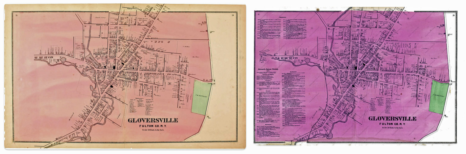
This question on the surface appears to be an arcane question about a specific historical map. What could be the significance of two or more versions of a map? In my research, I have found ‘three’ versions of a map of Gloversville, New York that is found in an Atlas published in 1868. The three versions are largely the same with a few notable differences.
These differences pose questions on whether the information contained in each of the versions of the maps were from different time periods. For example, were the differences the result of purposely leaving certain streets and buildings out of the map? Was the difference of not having a rail line in one map as opposed to another version of the map the results of republishing the atlas with updated information without indicating the publication as a revision?
The Stranahan & Nichols Map of Gloversville in 1868 was part of a local atlas of Fulton and Montgomery counties that also listed businesses on city maps.
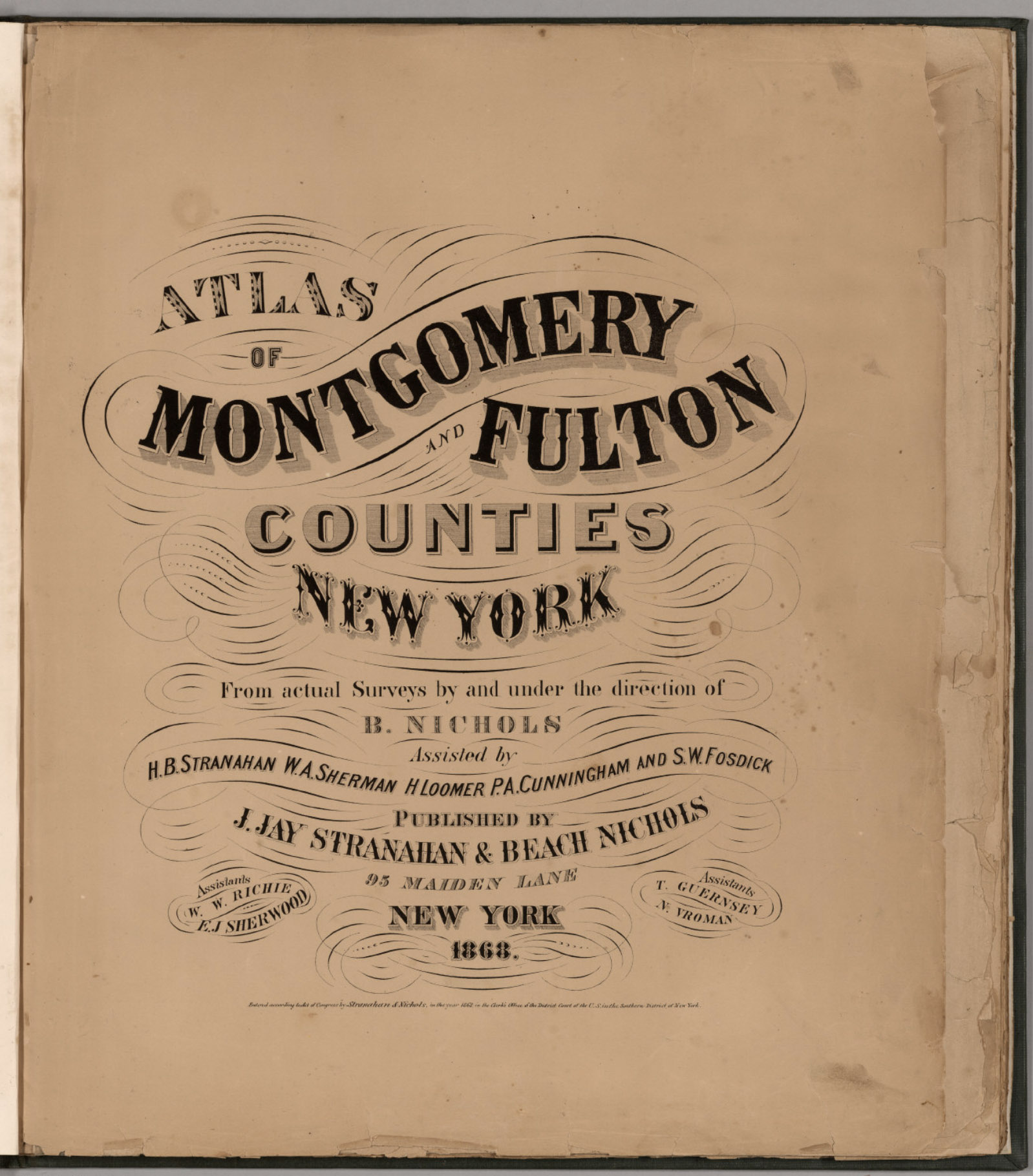
The map in question is part of a larger compendium of maps found in an atlas of Montgomery and Fulton Counties in New York. The atlas was published in 1868. Depending on how long it took to publish the atlas, I figure the information in the maps reflected how the towns and cities in these counties looked like around 1866 or 1867.
The atlas was created by J. Jay Stranahan and Beach Nichols. They were map publishers active in the mid to late 1800s, best known for their atlases of counties in New York state. [1]
In 1868, J. Jay Stranahan and Beach Nichols published the Atlas of Montgomery and Fulton Counties, New York, which contained detailed maps of the two counties and towns in that region including places like Ephratah, Mayfield, Gloversville and Johnstown.
I was interested in this map of Gloversville, New York since it shed light on specific individual relatives and family households that lived in Gloversville at the time that maps were produced.
The map had a direct impact on information regarding the location of John Sperber’s house and Louis Knoff’s house and tannery. John Sperber was the maternal grandfather of Harold Griffis. Louis Knoff was John’s brother-in-law.
Stranahan and Nichols Maps in the late 1800s
Beach Nichols led the surveying and map making efforts, with the atlases being created “from actual surveys by and under the direction of B. Nichols”. He was assisted by several people including H.B. Stranahan (likely related to J. Jay Stranahan), W.A. Sherman, H. Loomer, P.A. Cunningham and S.W. Fosdick. J. Jay Stranahan partnered with Beach Nichols to publish the atlases under the company name “J. Jay Stranahan & Beach Nichols”, located at 95 Maiden Lane in New York City. The atlas is 28 leaves in length and contains maps of the two counties.
It appears that J. Jay Stranahan and Beach Nichols produced at least one other historical atlas in addition to the Atlas of Montgomery and Fulton Counties, New York. Stranahan and Nichols also published an Atlas of Herkimer County, New York in 1868.
The fact that they published atlases of three different New York counties in the same year suggests they may have been engaged in a series of New York county atlas projects in the late 1860s.
A distinctive feature of their atlases was their focus on granular detail of these New York counties based on original surveys, rather than covering broader regions. This narrow geographic scope of individual counties appears to set the Stranahan and Nichols atlases apart from many other historical atlases that depict larger areas like full states, countries, continents, or the world.
The maps were drawn from actual surveys conducted by Stranahan and Nichols and their staff. The 1868 atlas featured hand-colored maps showing what specific areas in Fulton and Montgomery counties looked like over 150 years ago. The maps include details of towns, roads, railroads, rivers, and other geographic features. The maps also include the names of individuals who owned various pieces of real estate. This last attribute of the map provides a treasure trove of information for genealogists.
While conducting original surveys was an improvement over just compiling existing maps, survey techniques in the 1800s were not as precise as modern methods. There was likely some inaccuracy introduced in the surveying process. The maps were hand-drafted by Nichols and his assistants based on the survey data. The process of manually transferring survey measurements to the map introduced opportunities for human error and inaccuracy, especially before standardized map symbols were widely adopted.
As was common in the 1800s, features were probably generalized and minor details omitted to avoid overcrowding at the atlas’s scale. This generalization, while necessary, reduces the literal accuracy of the maps. [2]
The maps created by Stranahan and Nichols were part of a broader trend in the late 1800s of map publishers producing detailed county atlases, often based on new surveys, to meet demand for updated, accurate maps as settlement expanded across the country. Their work helped document the geography and development of New York counties during an important period of growth and change in the nineteenth century.
In addition to providing detailed maps of towns and cities, one version of the Stranahan and Nichols map provided brief lists of local businesses surrounding many of the maps in the atlas, similar to information contained in city directories. This version of the atlas was a hybrid of local maps and city directories. Perhaps Stranahan and Nichols saw the utility of fulfilling an unique niche in the map and city directory market by providing maps with the names of business and individuals along with brief lists of businesses on each map.
Large urban centers had city directories by the mid-19th century. Rural communities were sometimes covered in directories by the 1860s. Early city directories focused on businesses and tradesmen. By the mid-1800s, they expanded to include listings of residents, addresses, and occupations. City directories were published annually or biannually by private companies as a resource for salesmen and businesses before the widespread adoption of telephone directories in the early 20th century. [3]
The Three Versions of the 1868 Atlas of Montgomery and Fulton Counties
Table one provides a list of the major sources of the 1868 atlas that I have discovered in my research. Of these sources, all but two contain the same maps. The Internet Archive source only provides a digital copy of the title page. Two of the eight sources contain maps that are different from the other editions that are found in libraries and independent book sellers.
The editions marked in bold in table one are the maps I use in discussing the differences.
Table One: Major Sources of the 1868 Atlas of Montgomery & Fulton Counties
For purposes of discussion, I refer to the original version as the ‘1868 version‘, the second version as ‘1868 revision one‘, and the third version of the map as the ‘1868 revision two’ .
Differences Between the Three ‘1868’ Maps
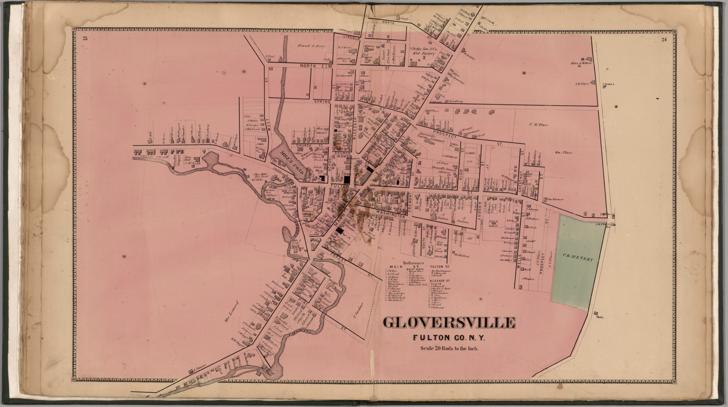
The ‘1868 version‘ of the map is a stylized map of Gloversville in 1868. Not all streets are documented in the map. The map focuses on the major roads in Gloversville. Home owners and owners of businesses are written next to many of the buildings drawn on the streets.
Map One:The 1868 ‘Original Version’ of the Gloversville Map
Click for Larger View | Source: Nichols, Beach; Loomer, H.; Sherman, W.A.; Cunningham, P.A.; Fosdick, S.W.; Richie, W.W.; Sherwood, E.J.; Guernsey, T.; Vroman, N., Atlas Of Montgomery And Fulton Counties, New York. From actual Surveys by and under the direction of B. Nichols. Assisted by H.B. Stranahan, W.A. Sherman, H. Loomer, P.A. Cunningham And S.W. Fosdick. Published By J. Jay Stranahan & Beach Nichols, 95 Maiden Lane, New York. 1868. Assistants, W.W. Richie, E.J. Sherwood. Assistants, T. Guernsey, N. Vroman. Entered … Stranahan & Nichols in the year 1868 … New York, New York: Stranahan & Nichols, 1868,digitalized by the David Ramsey Map Collection, David Rumsey Map Center, Stanford Libraries, https://www.davidrumsey.com/luna/servlet/detail/RUMSEY~8~1~226773~5506920:Gloversville,-Fulton-County,-New-Yo
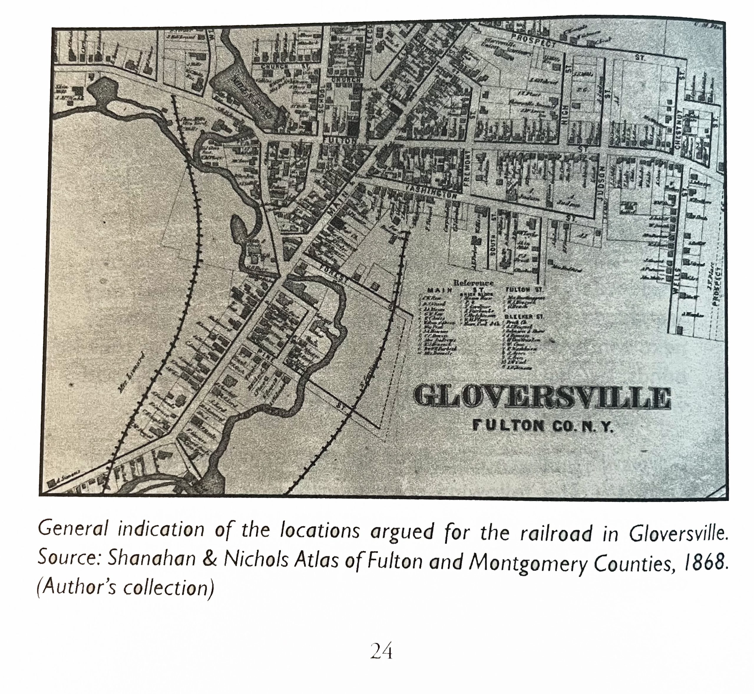
The 1868 ‘map revision one’ is the same as the original map except it has the rail line in the map. This map was found in a book about the Fonda, Johnstown and Gloversville railroad. The author, Paul Larne, claims that the map provides a ‘general path’ of the proposed railroad in the late 1860s.
Map Two:The 1868 ‘revision one ‘ of the Gloversville Map
Click for Larger View | Source: Larner, Paul, Our Railroad: The History of the Fonda, Johnstown & Gloversville railroad (1867 – 1893), Bloomington, Anchor House, 2009, Page 24
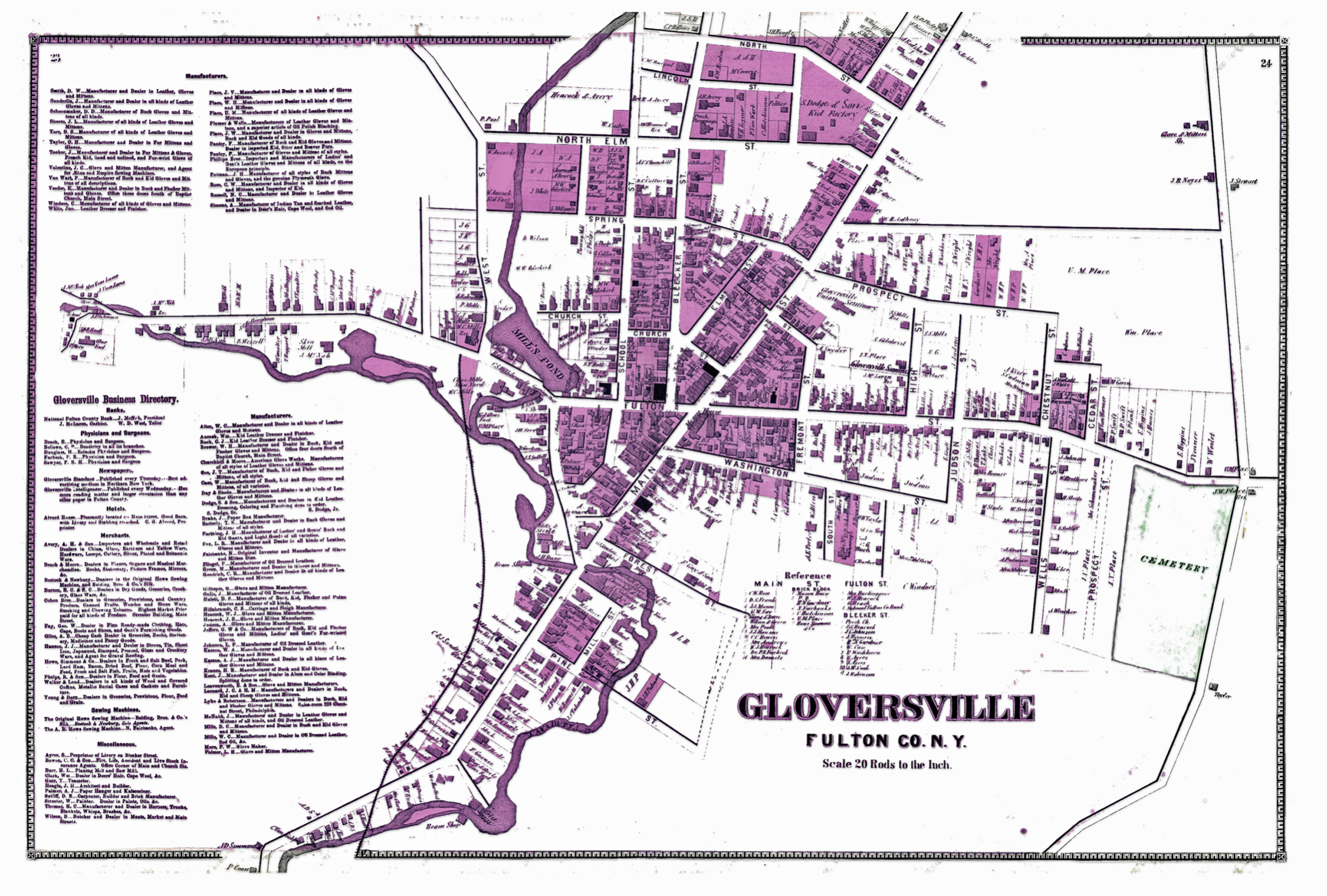
The 1868 reversion two ‘ map is similar to the first revision map but contains notable differences. There are more street areas documented, a list of manufacturers on the map is provided on the left hand portion of the map, and there is the presence of a rail line.
Map Three: The Revised ‘Version Two’ of the Gloversville Map
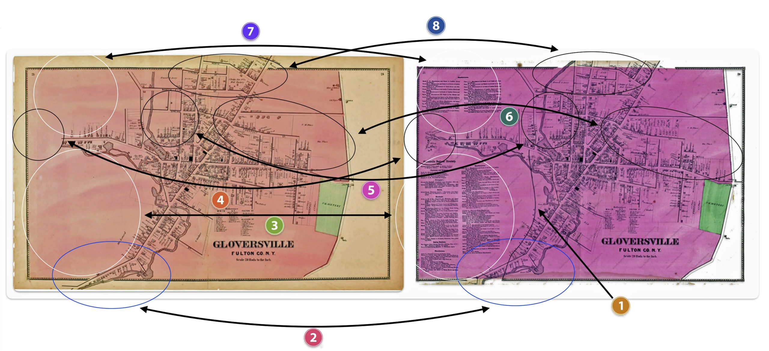
Reviewing and comparing the differences between the two versions of the Gloversville map is similar to isolating differences in a ‘Hocus Pocus’ newspaper cartoon. Some of the differences are readily apparent and others are slight.
My review of the two different versions of the ‘1868’ Stranahan & NicholsGloversville map detect at least eight major differences between the two maps.
These eight differences suggest changes to the original 1868 map were added to a major revision of the map and Atlas after1868 or there were multiple versions of the atlas published in 1868.
As Larner indicated, the addition of the Fonda, Johnstown & Gloversville Railroad (FJ&G) to the map possibly provided an indication of where the rail line was proposed. Another possibility is the rail line was added after the completion of the rail line.
The FJ&G was incorporated on June 16, 1867 with a capital stock of $300,000. A railroad construction contract was signed on September 18th, 1867.
“By provisions of the contract, the road is to be graded, the track laid, depots and water stations erected, and the whole distance in perfect running order for the cars on or before the first day of September next.”[4]
Progress on the construction of the rail line was slower than anticipated. There were a number of reasons for the delay. The route chosen contained significant obstacles of sand hills, quick sand, and the construction of bridges over cuts of land.
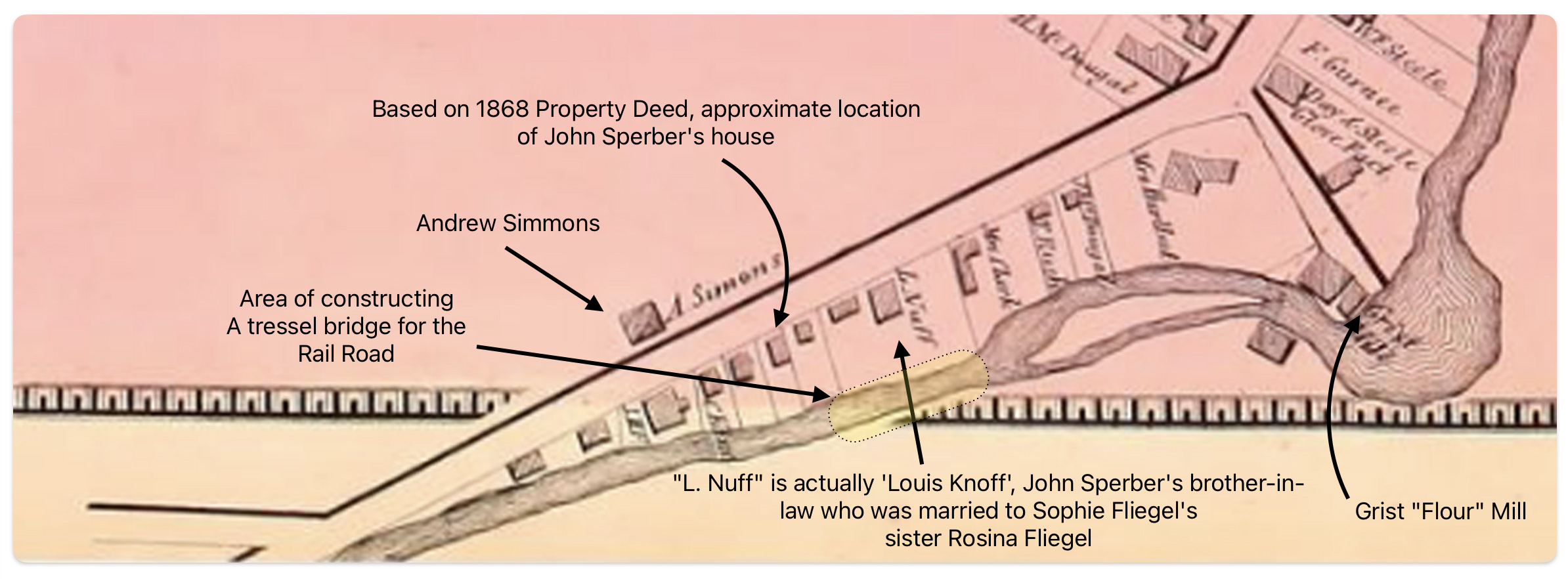
In December of 1867, a local newspaper indicated: “We found a large number of teams and men at work, grading the hill, where the route crosses the Cayadutta, just above the flouring mill. A long trestle bridge, we are informed will span the creek at this point, making the grade gradual and easy. After this grade is overcome, the remainder of the route will be comparatively easy.”[5]
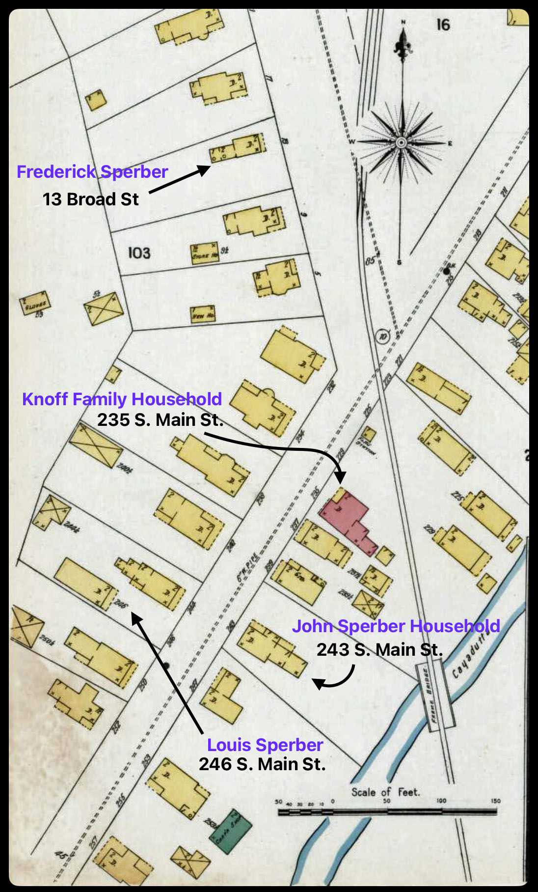
The area where the workers were working over the Cayadutta Creek was where Louis Knoff and John Sperber had property. Knoff purchased his property in 1867 and Sperber purchased his property in 1868. As reflected in map four below, the Knoff property is identified in the ‘1868 version‘ of the map. Evidently, Stranahan and Nichols spelled Knoff’s name phonetically as Nuff.
Map Four: Blow Up Area of the ‘Original 1868 version’ of the Map
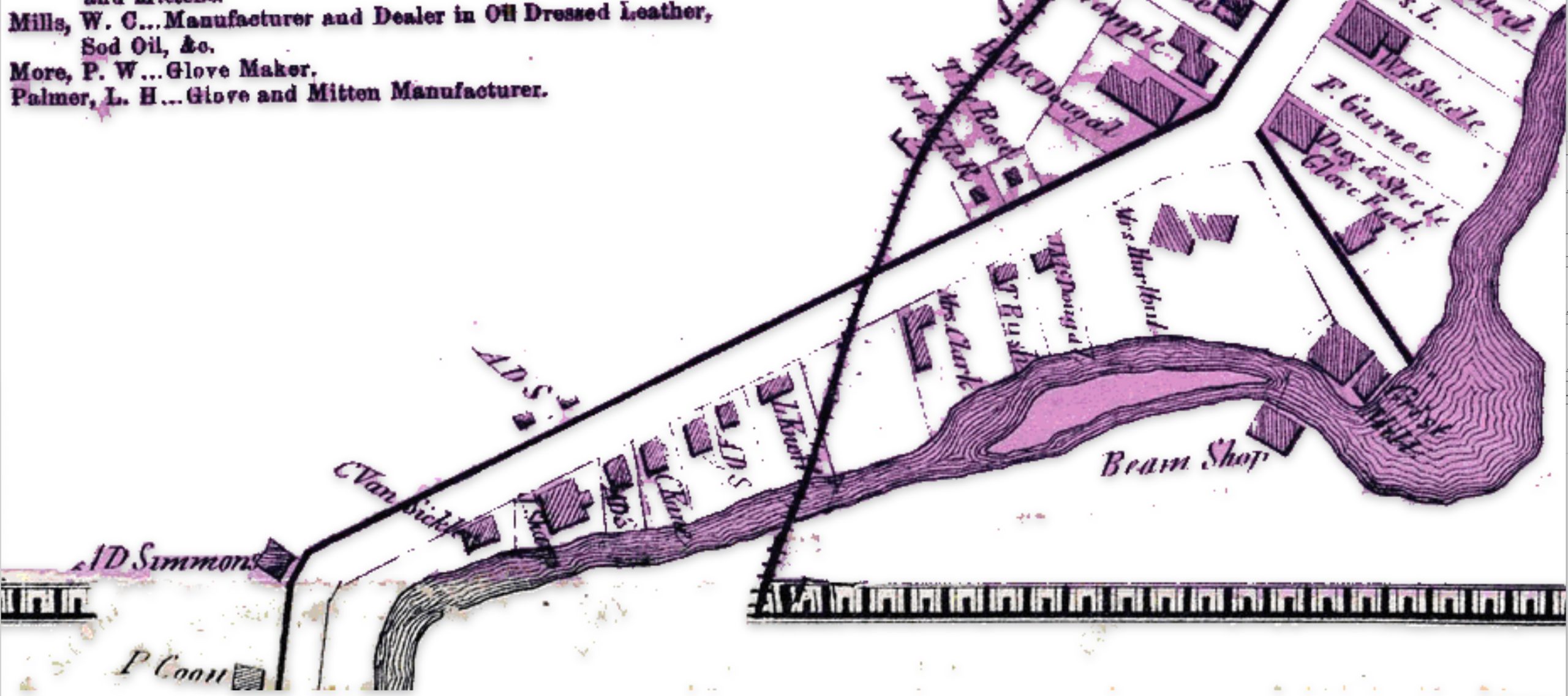
If we look at a blow up of the same area in the ‘1868 reversion two’ map, we see the existence of a rail line going diagonally across Knoff’s property. Knoff’s name is correctly.
Map Five: Blow Up Area of the ‘revised post – 1868 version’ of the Map
It took an additional three years to acquire access to land and build the track from Fonda to Gloversville. The ability to complete this task in three years, given the budgetary demands, the turnover of building contractors, geographical hurdles, court cases and local politics is noteworthy. [6]
On November 29, 1870, the first passenger train pulled by a wood-burning steam engine arrived in Gloversville, marking the completion of the initial 16-mile track section from Fonda to Johnstown and Gloversville. The track was extended another 16 miles from Gloversville to Northville in 1875.[7]
Since the initial FJ&G rail line to Gloversville was not completed until late 1870, the online version of the Atlas provided by Map Works Residential Genealogy was possibly published no earlier than 1871.
An alternative argument is the “1868 reversion one’ map is a modified version of the original map and was published when the rail road that was being built. This version the 1868 map with the rail line is presented in a publication about the creation of the FJ&G railroad. [8]
The major differences between the three versions of the 1868 Atlas are portrayed in the comparison maps below. The Map reversion two is the same as the original version except it has the ‘proposed’ rail line in the map.
Maps Six:Differences between the ‘Original Version’ and ‘Revision Two’ of the ‘1868’ Gloversville Map
The following are the major differences to the two versions of the Atlas maps of Gloversville.
Table Two: Comparison of the Three Versions of the 1868 Map
Difference
Rumsey Original Version
Laner Book Revesion one
Map Works Revision Two
One
The FJ&G rail line is absent
The FJ&G rail line is present
The FJ&G rail line is present
Two
S. Main Street stops before it curves south
S. Main Street stops before it curves south
S. Main Street continues after it curves south
Three
This section is blank
This section is blank
Local manufacturers are listed
Four
This section is blank
This section is blank
Map extends road with huses and businesses
Five
Map provides major roads in area
Map provides major roads in area
Map provides detailed informaiton on buildings
Six
Map provides major roads in area
Map provides major roads in area
Map provides detailed buildings in area
Seven
This section is blank
This section is blank
Provides information on local manufacturers
Eight
Map provides major roads in area
Map provides major roads in area
Map provides detailed buildings in area
The ‘Second Revision’ of the 1868 Map
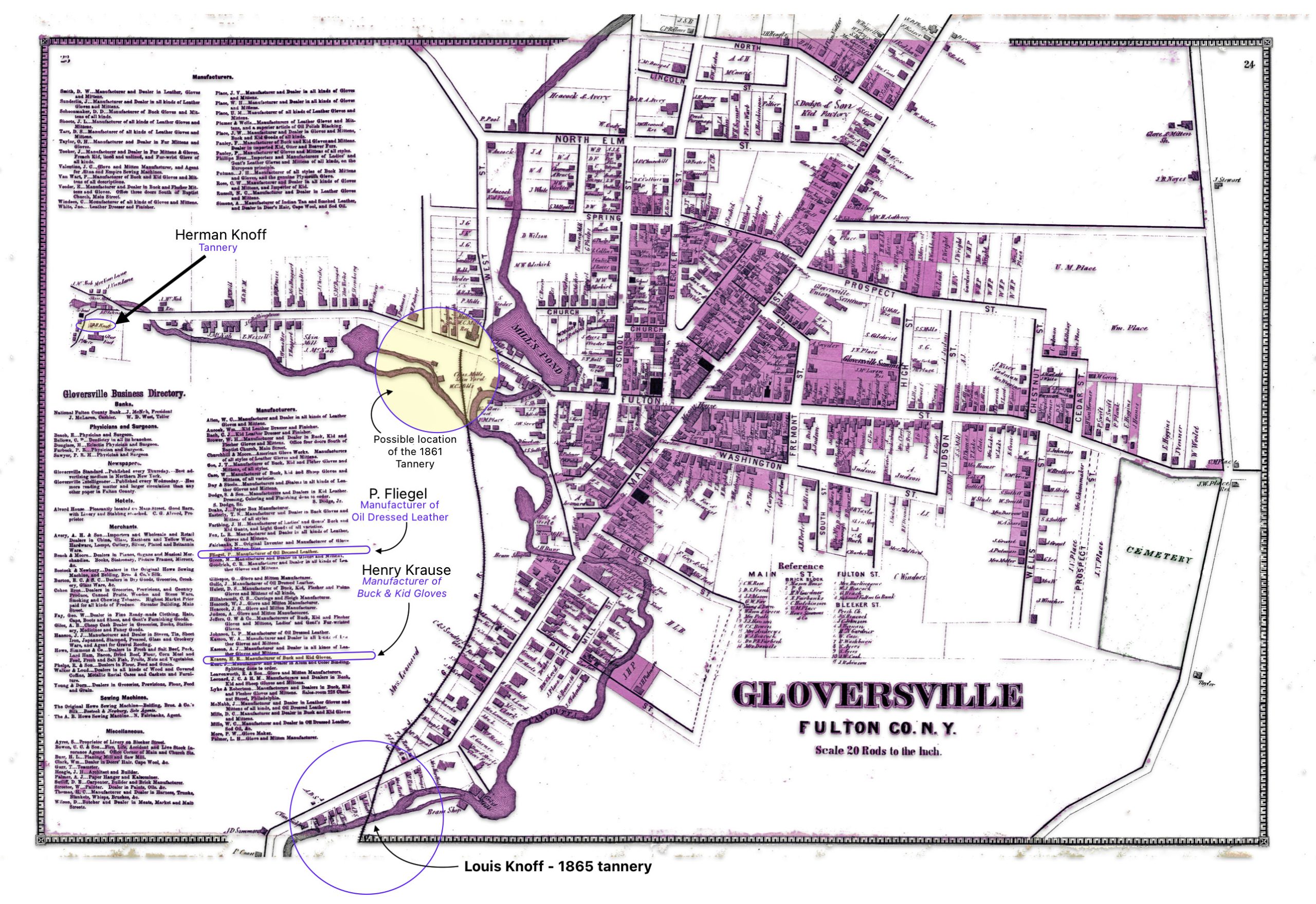
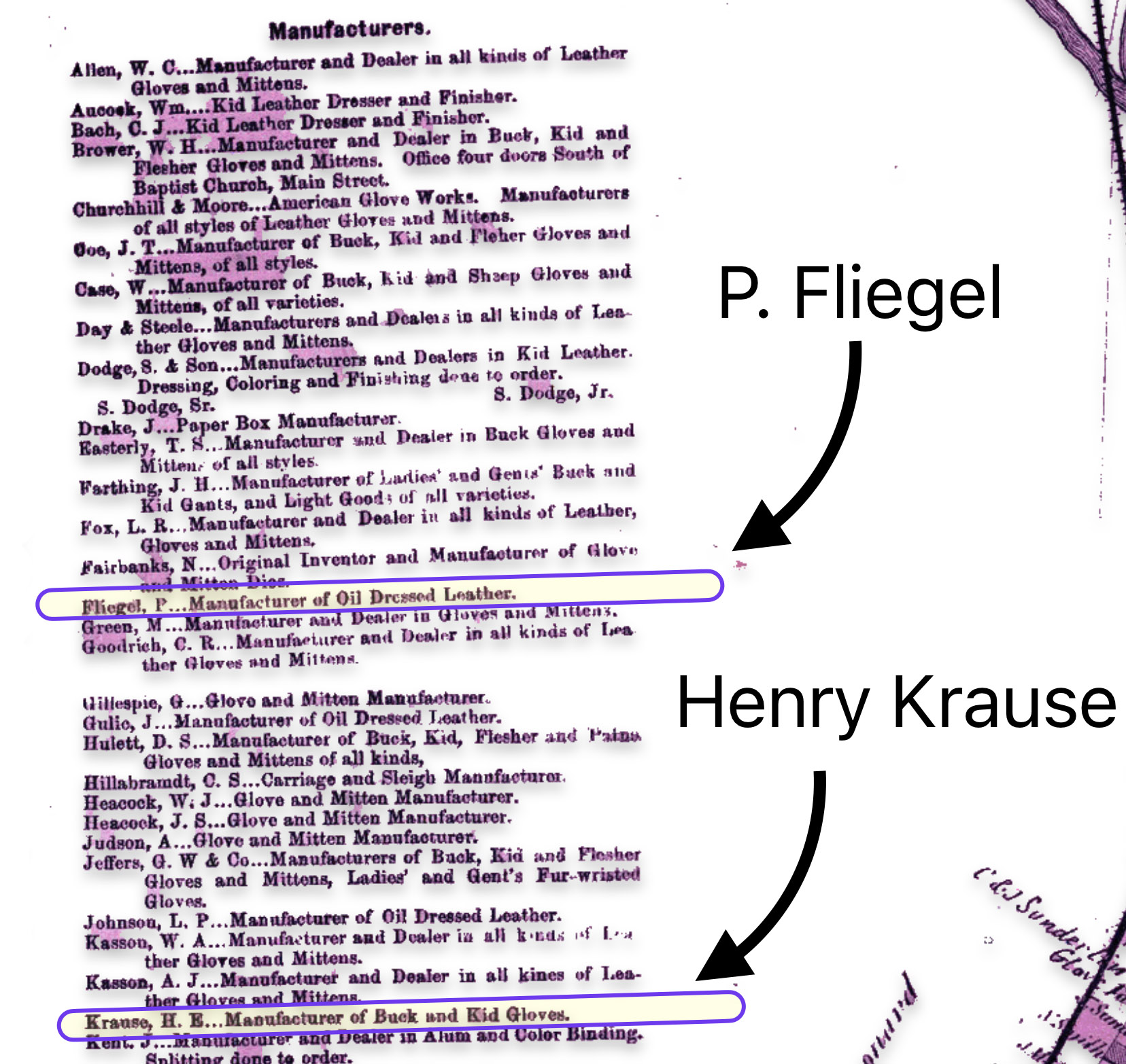
The map is fairly accurate but not exact and does not depict the entire city of Gloversville. The added information in the second revision of the 1886 map has direct import on information on family members in the Griffis family tree. As noted in map seven below, the second revision of the map provides information on Herman Knoff, Philip Fliegel and Henry Krause.
Map Seven: The Nichols Map of Gloversville 1868– “Map Revision Two” [9]
The following map eight is a close up of the location of Louis Knoff’s second tannery that was established, as stated in his obituary, in 1865. [10] It is a blow up of the circled area in map two of the lower left hand portion of the map.
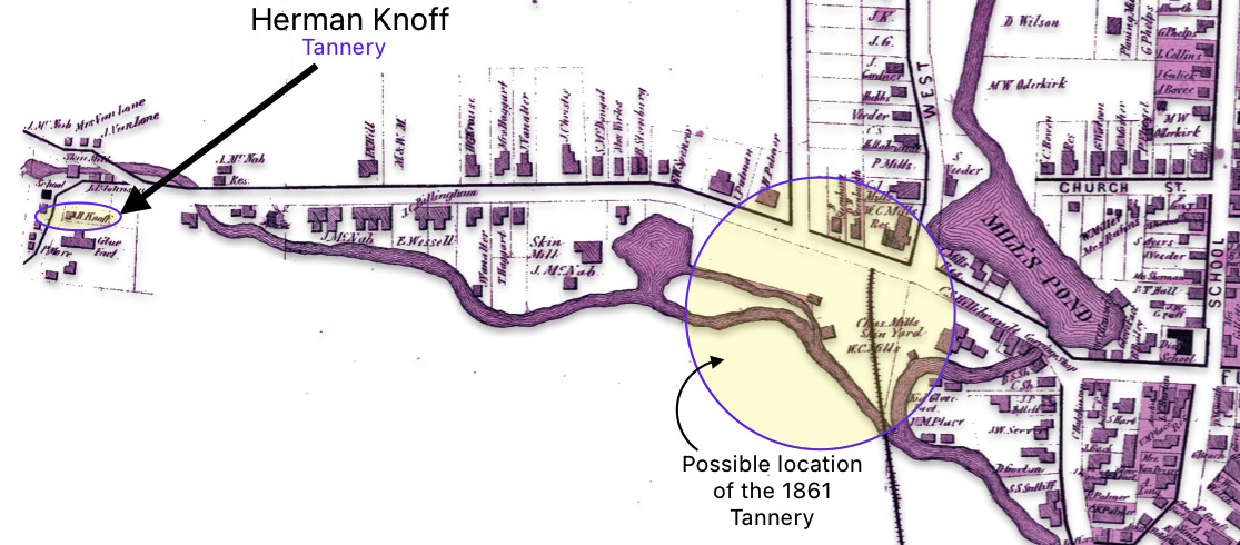
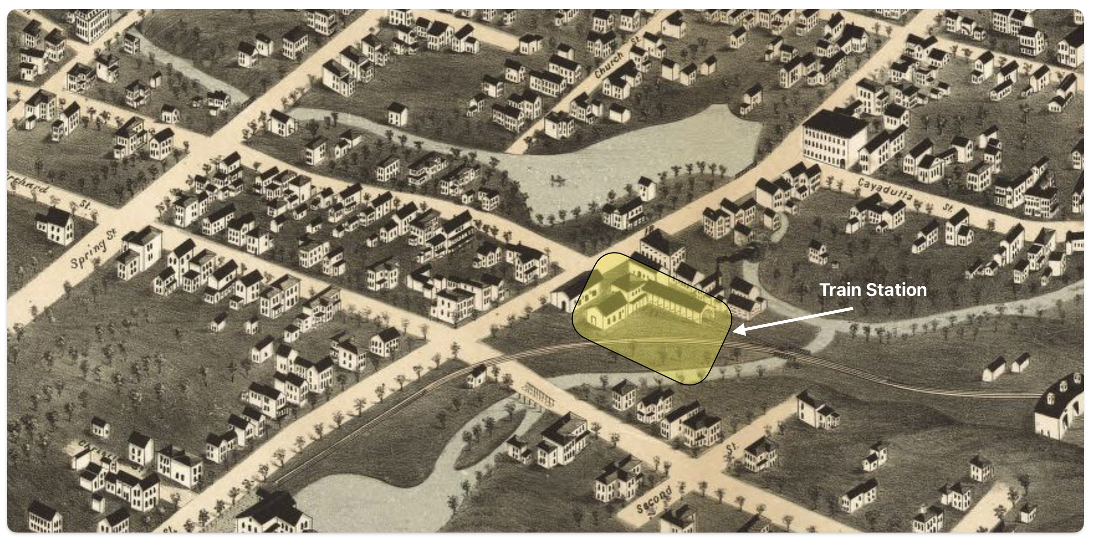
Map nine below is a blow up of a middle portion of the map two which shows where one of Louis’ relatives, Herman Knoff, had a tanning business in 1868. Map nine also shows the possible area where Louis Knoff’s original tannery in 1861 was located. “In 1861 he established his own tanning business and had a tanning mill near the railroad station.” [11]
Map Nine: Location of Knoff’s Tannery in 1861 & Brother Herman’s Tannery in 1868
I have indicated in the map above, with a highlighted yellow circle, the approximate location of Louis’ 1861 tannery that was reported to be near where the rail road station existed when his obituary was written. The rail station was not built until 1870 and it obviously is not identified in the 1868 map above. The Gloversville rail station was located on West Fulton Street, close to the site of the present day Rail Station Park. [12]
As indicated in map ten, the revised two map also provides a list of local businesses surrounding the map of Gloversville. It is notable that Philip Fliegel and Henry Krause are listed as ‘manufacturers. Philip Fliegel was the brother of Rosa and Sophie. He was listed as a ‘manufacturer of oil dressed Leather’. Henry Krause was the husband of Catherine Fliegel, the sister that first came to America. Henry is listed as a “manufacturer of Buck and Kid Gloves”.
Map Ten: List of Manufacturers as depicted in the Stranahan & Nichols Map of Gloversville in 1868
The Atlas of Montgomery and Fulton Counties, New York provides an authoritative, detailed look at a specific region and time in history. The information contain in the various version of the Atlas maps make it a significant resource for scholars, genealogists, and others researching the history of these New York state counties or life in the post-Civil War. As a primary source, it offers a unique window into the past.
[1] The Atlas can be found on line and original copies are available for purchase at a number of book store that specialize in historical artifacts and at auction sites.
Nichols, Beach; Loomer, H.; Sherman, W.A.; Cunningham, P.A.; Fosdick, S.W.; Richie, W.W.; Sherwood, E.J.; Guernsey, T.; Vroman, N., Atlas Of Montgomery And Fulton Counties, New York. From actual Surveys by and under the direction of B. Nichols. Assisted by H.B. Stranahan, W.A. Sherman, H. Loomer, P.A. Cunningham And S.W. Fosdick. Published By J. Jay Stranahan & Beach Nichols, 95 Maiden Lane, New York. 1868. Assistants, W.W. Richie, E.J. Sherwood. Assistants, T. Guernsey, N. Vroman. Entered … Stranahan & Nichols in the year 1868 … New York, New York: Stranahan & Nichols, 1868, https://archive.org/details/dr_title-page-atlas-of-montgomery-and-fulton-counties-new-york-from-actual-0668002
The “map reversion two” map in the story is from Historic Map Works: Residential Genealology, Portland, Maine. Historic Map Works has two websites which host historic maps. The first is historicmapworks.com which is aimed at individual subscribers and the second is Historic Map Works Library Edition which supports public libraries and universities.
The majority of their map database was created by scanning an original map at a high resolution and removing major imperfections while maintaining the look of an antiquarian map. The maps are then uploaded and cataloged for viewing on our website. The maps are geocoded each map to a modern map to enable the search by address function. Other methods to view their map collection include browsing by geographic location as well as searching our maps via keywords, town names, makers names, or by year. See: Gloversville, item number #US34393, https://historicmapworks.com/Map/US/34393/Gloversville/
I removed most of the coloring that had been added to the Mapworks version of the Gloversville map. While I purchased a digital copy of the map to respect their reproduction efforts, they have a distracting, reoccurring water mark on the reproduced digital copies of the map. I removed these by removing the colorized layer on the map.
[10] The obituary for Louis Knoff provides a wealth of biographical information on Louis and on his marriage to Rosa Fliegel. The obituary indicates:
He passed away, primarily due to heart disease, on April 7th, 1893 at 11:30 pm;
At the time f his death, he lived at 149 South Main Street;
He was born in Barnstadt, Prussia on January 8, 1828;
He learned the trade of tanning of leathers in Breslau, Prussia;
He came to Gloversvlle in 1849 and was employed Gilbert Burr and worked in Johnstown for several years;
In 1861 he established his own tanning business and had a tanning mill near the railroad station;
In 1865 he built a factory and tannery on South Main Street;
He married Pauline Gansel in 1856;
Pauline died in 1862;
He remarried Rosa Fliegel in 1866;
Rosa died in 1891;
He was survived by two sons Herman and Louis Junior; and
Louis was a member of the Congregational Curch in Gloversville.
Louis Knoff Obituary, The Gloversville Daily Leader, 8 April 1893, Page 8
Click for Larger View
[11] Ibid
[12] The Fonda, Johnstown & Gloversville Railroad (FJ&G) was founded in 1867 and construction was completed in 1870, connecting Fonda, Johnstown and Gloversville. The first train ran from Fonda all the way to Gloversville in 1870. When the FJ&G railroad began operations, the Gloversville rail depot would have been located on West Fulton Street where the current Rail Station Park is now situated. The map of Gloversville from 1875 likely shows this original rail station location, just a few years after the railroad opened.
As stated in the first part of this multipart story:
“Johann left his homeland, traveling from the Rhine Valley to a port on the English Channel. He then endured the journey across the Atlantic in a packet ship. He married a German lady with a child who experienced the same journey from Baden, Germany. They established their roots in the fast growing twin cities of Johnstown and Gloversville, New York. Johann became a glove maker and eventually worked in one of the largest glove making manufacturing firms in the county. A firm that was run by one of Teddy Roosevelt’s college roommates.” – excerpt from part one of the story of John Wolfgang Sperber
The Maturing Glove Industry, Growth and Prosperity in the 1890s
The Sperber families were living in good times in the 1890s, even when there were bleak stretches in the American economy. Albert Aaron, a superintendent of the Louis Meyers & Sons Glove company in Gloversville stated “When business is bad throughout the United States, glove business is dull“. [1]
In the 1890s, the United States experienced a period of economic instability and transformation. While the country had become the world’s most productive economy by 1890, surpassing Britain, it faced significant challenges during this decade. The 1890s was a decade of stark contrasts for the U.S. economy – overall growth and industrialization alongside a severe depression, inequality, and unrest. The economy of the United States in the 1890s was marked by a severe depression known as the Panic of 1893, followed by a period of recovery and growth in the latter part of the decade. [2]
“The year 1890 saw the acceleration of the fine glove industry that became Fulton County’s claim to fame. … Between 1890 and 1900, there was a 47 percent increase in the value in the county’s glove production. In the same decade immigrants increased the local population by 33 percent, while the number of workers rose by 59 percent, implying an huge increase in two-income families and in the number of part-time homeworkers. Johnstown produced 40 percent as much as Gloversville.… In 1900, the county produced 57 percent of all gloves produced in the United States. [3]
Modern technology was incorporated into glove shops and tanneries. While gas continued to be used for lighting in most homes and factories, electric power for lighting was introduced. The Gloversville power company was incorporated in 1890 using steam generators and quickly began to power street lights and industries. Within a year Gloversville factories had acquired 500 electric powered sewing machines. Natural light was still essential for cutting and making gloves despite the use of gaslights. [4]
The Sperber Household in the ’90s
Through the 1890s, the Sperber household witnessed the emancipation of all of their children and the joys of marriage and death.
As reflected in table one, John and Sophie had three children still living with them at the beginning of the decade. Ida Sperber, the youngest of the family was 14 and in school. Louis Sperber was around 21 and working. Kate Sperber was 26 and sewing gloves at home
At the end of the decade, John was a widower and was living with his two daughters Ida and Kate and Ida’s husband Charles Griffis.
Table One: John Sperber’s Family and Household in the 1890s
Name
Family Relation
Birth-Death Dates
Age 1890 – 1900
Present in house- hold entire decade
John
Father
1828-1905
62-72
Yes
Sophia
Mother
1832-1897
58-68
Until 1897
Rose
Daughter
1856-1942
34-44 *
No
Frederick
Son
1859-1936
31-41 **
No
Louis P.
Son
1869-1920
21-31 ***
First 3 years
Kate
Daughter
1864-1941
26-36
Yes
Ida May
Daughter
1876-1954
14-24
Yes
* Rose Sperber married at 20 years of age in 1876, left the household and lived in Brooklyn, New York; ** Frederick Sperber did not live in his father’s household in the 1890’s. ** Louis Sperber married in 1893 and lived in his own household.
Available Historical Evidence in the 1880s and 1890s
For Federal and New York state census information, there is a ‘dark age’ between 1880 and 1905.
Due to a number of political and bureaucratic conflicts, no state census was taken in 1885. New York State coordinated a census in 1892, and skipped the census which should have occurred in 1895, and then resumed census-taking every ten years in the fifth year of each decade—1905, 1915, and 1925. Records for the 1992 census are not available for all counties. All but 13 New York counties are available for this census. Fulton county is not available. [5]
Most of the 1890 Federal census records were badly damaged by a fire in the Commerce Department building in January 1921. Only fragments of the general population schedules for some states and D.C. survived. There are no records of Fulton county for the 1890 census. [6]
While we do not have access of census material to glean a snapshot of the composition of the Sperber household during this period of time. However, city directories may provide clues as to where family members resided and what was their stated occupations. Comparing family member information from the directories can provide a basis to determine the locations of family members within the city. Of course this is a hit or miss discovery since not all individuals were canvassed or elected to actively post their name, address, and stated occupation in city directories. Incomplete evidence is better than none at all. The question is not whether directories are perfect, but whether their imperfections are so serious as to preclude their use completely. [7]
The first known city directory in the United States was published in 1786 for the city of Philadelphia. In the early 1800s. City directories began to be published more regularly for major cities like New York, Boston, Baltimore and Charleston. By the mid-nineteenth century, city directories became increasingly common and were being published for many cities and towns across the country. [8]
City directories in the 1800s typically contained an alphabetical listing of residents and businesses along with their addresses. [9]
The History of Street Numbering Houses and Businesses
“The custom of numbering houses is now so well established in all cities or towns of any size, and house numbers are so indispensable to modern urban life , that it is natural for even the historian to rely too blindly on them.” [10]
Having a coordinated address system, including the match of property numbers to the nearest numbered blocks is a system that evolved in different ways in cities and towns. As population density and size of towns started to increase there was a need to more precise ways to locate a given property or inhabitants in a given town or city. Early approaches merely listed the location of a given town or city for individuals. As the population grew in a given area, street were added as unique geographic identifiers. [11]
“The frequent changes which take place in the numbering of streets are a great inconvenience. They are often made without notice to the occupier of a dwelling, the plate containing the number over his door is changed without his knowing it, so that he who goes to bed at No. 50 in his street, may wake up the next morning at No. 100 … these proceedings are very uncomfortable to householders. They occasion confusion and mistakes in the delivery of letters and packages, and perplex strangers who re looking for the residence of their acquaintances in town.”[12]
The Sperbers in City Directories
The change in the numbering of households over time is apparent in Gloversville. As reflected in the table below, while John Sperber was in the same house since 1868, the address for John Sperber’s house changed three times between 1881 and 1903. Between 1881 and 1887, the Sperber household was located at 12 South Main Street. Between 1888 and 1890, their address was 155 South Main Street. After 1894, their address was 243 South Main Street. This trend suggests that the area became more complex from development of houses and commercial establishments.
Table One: John Sperber – Stated Occupation and Residence Addresses Found in Gloversville City Directories 1881 to 1903
Year
Occupation
Address
Source
1881
Glove Maker
12 S Main
Gloversville Directory
1882
Glove Finisher
12 S Main
Gloversville Directory
1883
Glove Finisher
12 S Main
Gloversville Directory
1884
Glove Cutter
12 S Main
Gloversville Directory
1885
Glove Finisher
12 S Main
Gloversville Directory
1886
Glove Finisher
12 S Main
Gloversville Directory
1887
Glover
12 S Main
Gloversville Directory
1888
Glove Finisher
155 S Main
Gloversville Directory
1889
Glover
155 S Main
Gloversville Directory
1890
Glover
155 S Main
Gloversville Directory
1892
Glover
155 S Main
Gloversville Directory
1893
Glover
155 S Main
Gloversville Directory
1894
Glover
243 S Main St
Gloversville Directory
1900
Glove Finisher
243 S Main St
Federal Census
1903
Glover
243 S Main
Gloversville Directory
Source: Gloversville City Directories, published by O. .H. Bame & Co
Reviewing the city directories during this time period reveals a number of interesting details of where Sperber family members lived in relation to each other. One must keep in mind that similar to the changes in house numbering for John Sperber’s home, the numbering of households for his sons, Frederick Sperber and Louis Sperber, also changed. Despite the changes in house numbers, it is apparent that Sperber family members lived close to each other or lived together in the 1880s and 1890s.
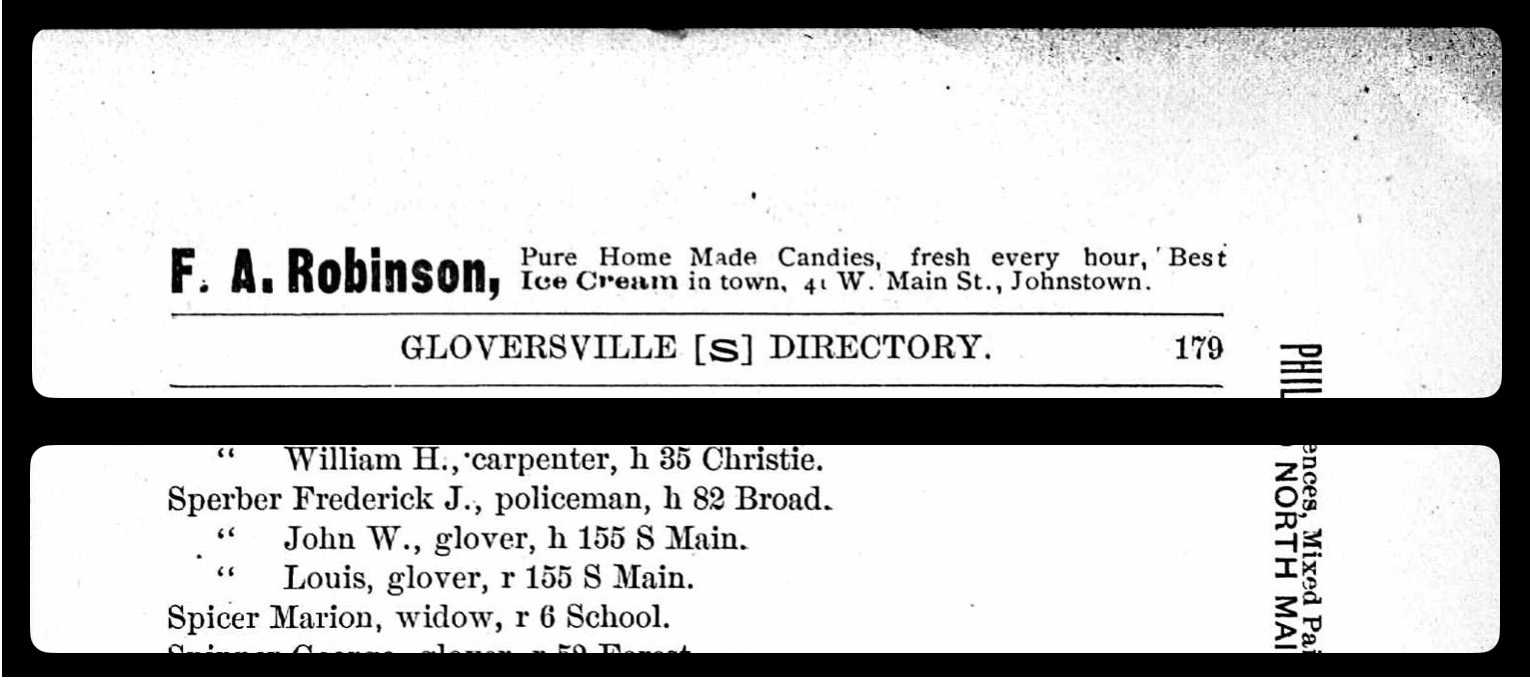
The following two images are from the 1892 and 1893 Gloversville Directories. The top part of images one and two are the page headers of the directory pages and the lower part is the portion of the pages that have Sperber family member listings.
There are three members of the Sperber family listed in the 1892 and 1893 city directories. In 1893 Louis Sperber was living in his father’s household, located at 155 South Main Street. John Sperber and his son Louis are listed as ‘glovers’. John’s older son, Frederick, a policeman, was living at 82 Broad Street.
Image One: 1892 Gloversville City Directory
Click for Larger View | Source: Gloversville City Directory 1892, O. .H. Bame & Co., Page 179
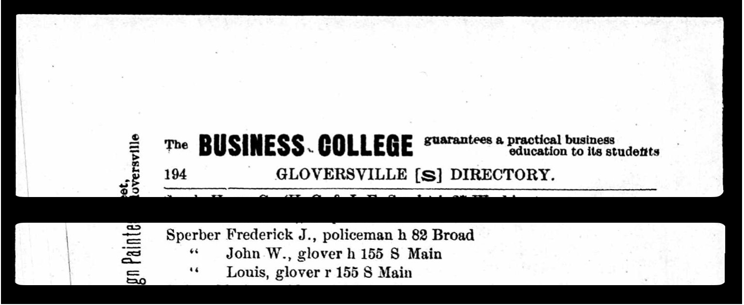
Image Two:1893 Gloversville City Directory
Click for Larger View | Source: Gloversville City Directory 1893, O. .H. Bame & Co., Page 194
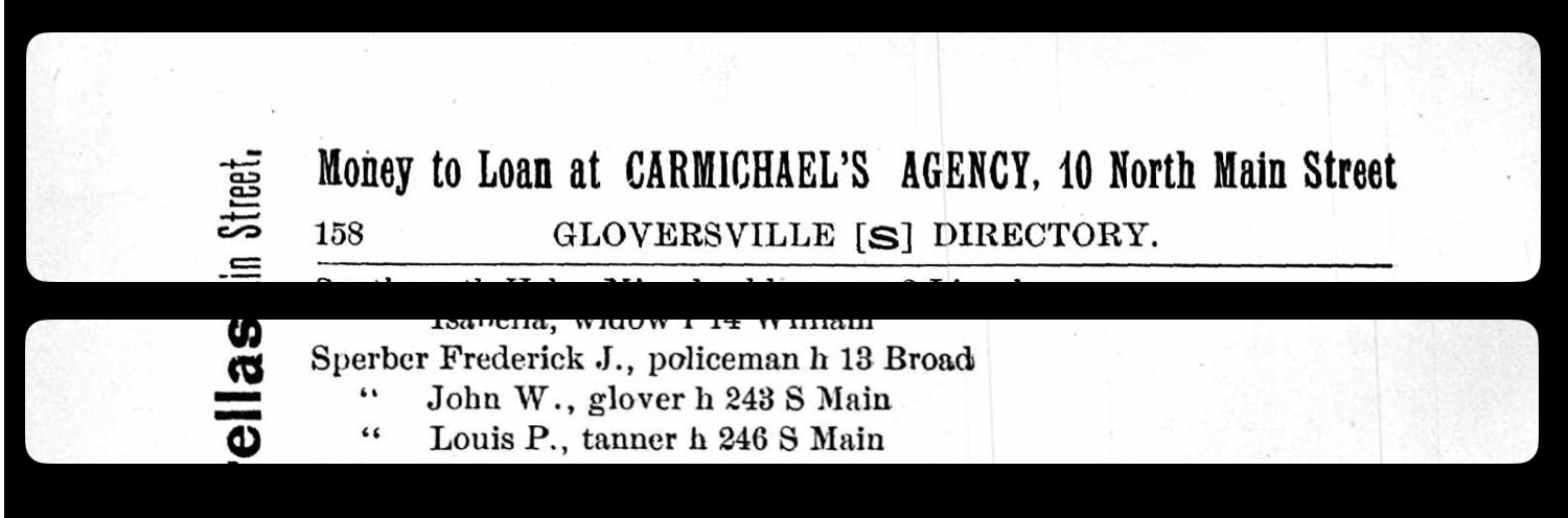
Image three is a page from the 1894 city directory (see below). As indicated in table one, there was a second change in the city numbering of households between the publication of the 1893 and 1894 city directories. While the address numbers changed John Sperber and Frederick Sperber resided in the same domiciles.
Image Three: 1894 Gloversville City Directory
Click for Larger View | Source: Gloversville City Directory 1894, O. .H. Bame & Co., Page 158
In the 1894 city directory, Louis P. Sperber, was listed as a tanner and lived across the street from his father’s house at 246 South Main Street.
Perhaps the major reason Louis moved out of his father’s house between 1893 and 1894 was that he married Anna Sprung on May 10th, 1893. [13] It is not known if the property that Louis lived at in 1894 is the property that was purchased in Sophia Sperber’s name in 1882, as discussed in part seven of this story .
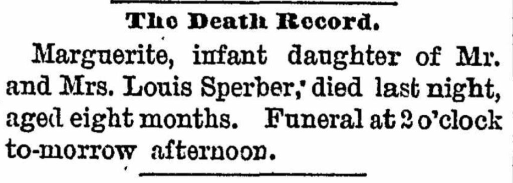
They had a daughter Marguerita who was born the following year on August 5, 1894. However, she passed away at the age of 8 months on April 8, 1895. [14] It is not known why she died at such a young age.Multiple infectious diseases posed serious risks to children’s health in America in 1894, with smallpox, diphtheria, measles and scarlet fever causing significant epidemics and mortality in the late ninetenth century. [15]
Frederick Sperber continued to live on Broad Street but the house number changed from 82 to 13 Broad Street between 1893 and 1894..
While Kate Sperber was not listed in the directories in the 1880s and 1890s, it is assumed that she was living with their parents. Kate was John and Sophias’ fourth child. While Kate was 30 in 1894, Kate never married and lived with her parents in the 1890’s and then with her sister Ida’s family throughout her life.
Ida Sperber, the youngest in the family, was 18 in 1894. Ida was probably living at home and working as a glover maker.
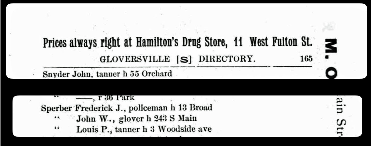
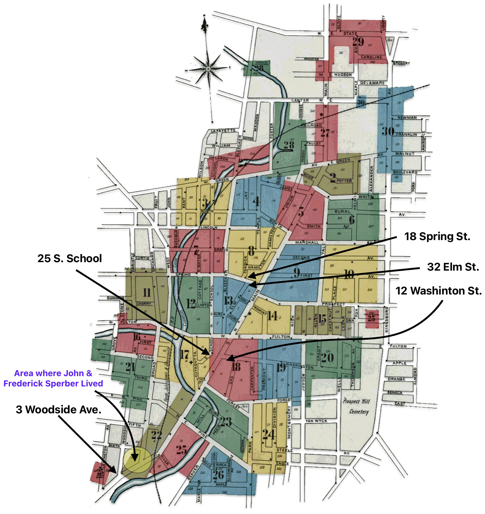
As reflected in the 1895 city directory below, in 1895 John and Fredrick continue to live in their respective houses. Louis Sperber relocated to 3 West Woodside Avenue.
Image Four: 1895 Gloversville City Directory
Click for Larger View | Source: Gloversville City Directory 1894, O. .H. Bame & Co., Page 158
Correlating City Directory Information with Historical Maps
Genealogists can gain valuable insights using historical city directories in conjunction with maps made during the same time frame to analyze and document detailed historical spatial information on where relatives lived in relation to other family members in the late 1800s and early 1900s. The use of directories and maps can also account for research challenges like changing street names and city boundaries over time. The combination of these two sources allows genealogists and researchers to ‘geocode’ historical address data to a high degree of accuracy. [16]
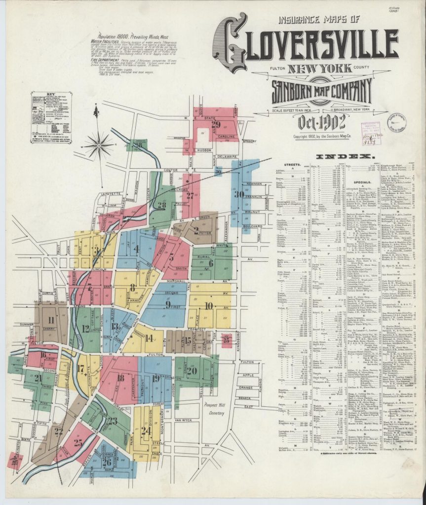
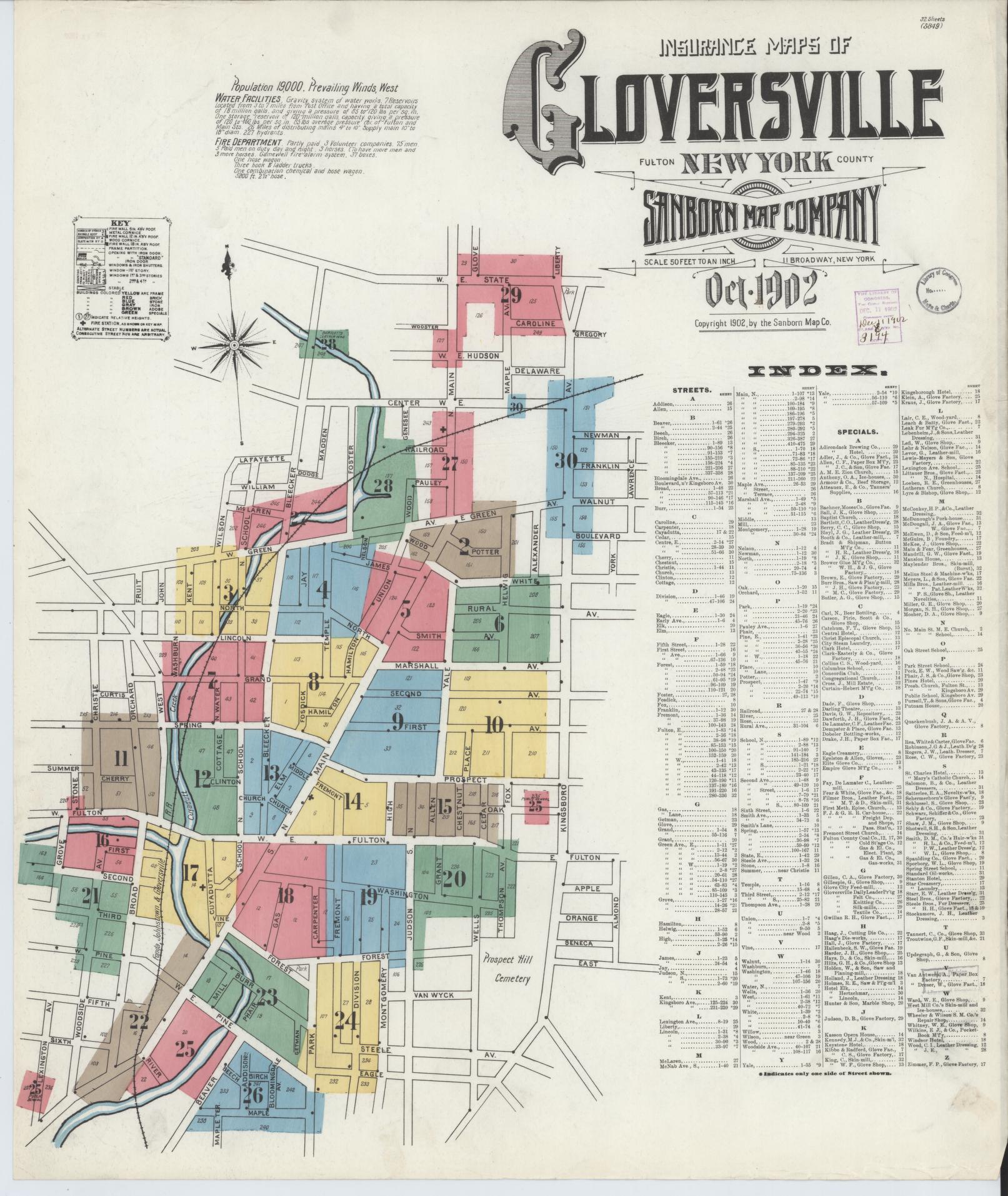
Map One: Title Page for Sanborn Maps of Gloversville 1902
Click for Larger View | Sanborn Fire Insurance Map from Gloversville, Fulton County, New York, Sanborn Map Company, Oct 1902, Library of Congress Geography and Map Division Washington, D.C.http://hdl.loc.gov/loc.gmd/g3804gm.g3804gm_g059511902
The 1902 Sanborn map series had 32 maps of the city of Gloversville. The Title page, above, provides a street index of the city streets and a color coded depiction of each of the specific areas that have individual maps of the buildings in the city.
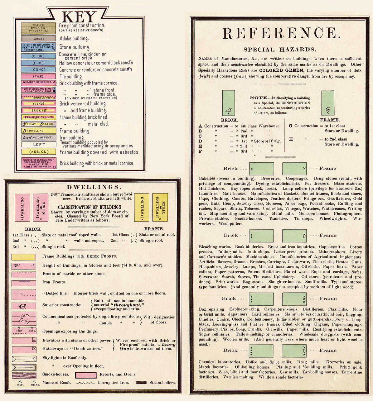
The Sanborn Map Company was a prominent American publisher of detailed fire insurance maps from 1867 to the late 20th century. The maps provided detailed information about the size, shape, construction materials and function of buildings in urban areas. They also included details like street names and widths, property boundaries, building use, and the location of water mains, fire alarms and fire hydrants and the exact street numbers of buildings. [17]
While city directories were more of a listing focused on occupants, the Sanborn maps provided a visual representation emphasizing the characteristics of the commercial and residential builldings. The Sanborn maps used standardized colors and symbols to efficiently convey structural information relevant for assessing fire risk. [18] However, the two resources are very complementary when used together for historical research. The city directories help identify specific people, businesses and addresses to locate on the Sanborn maps. The maps then provide rich detail about what those properties looked like at the time.
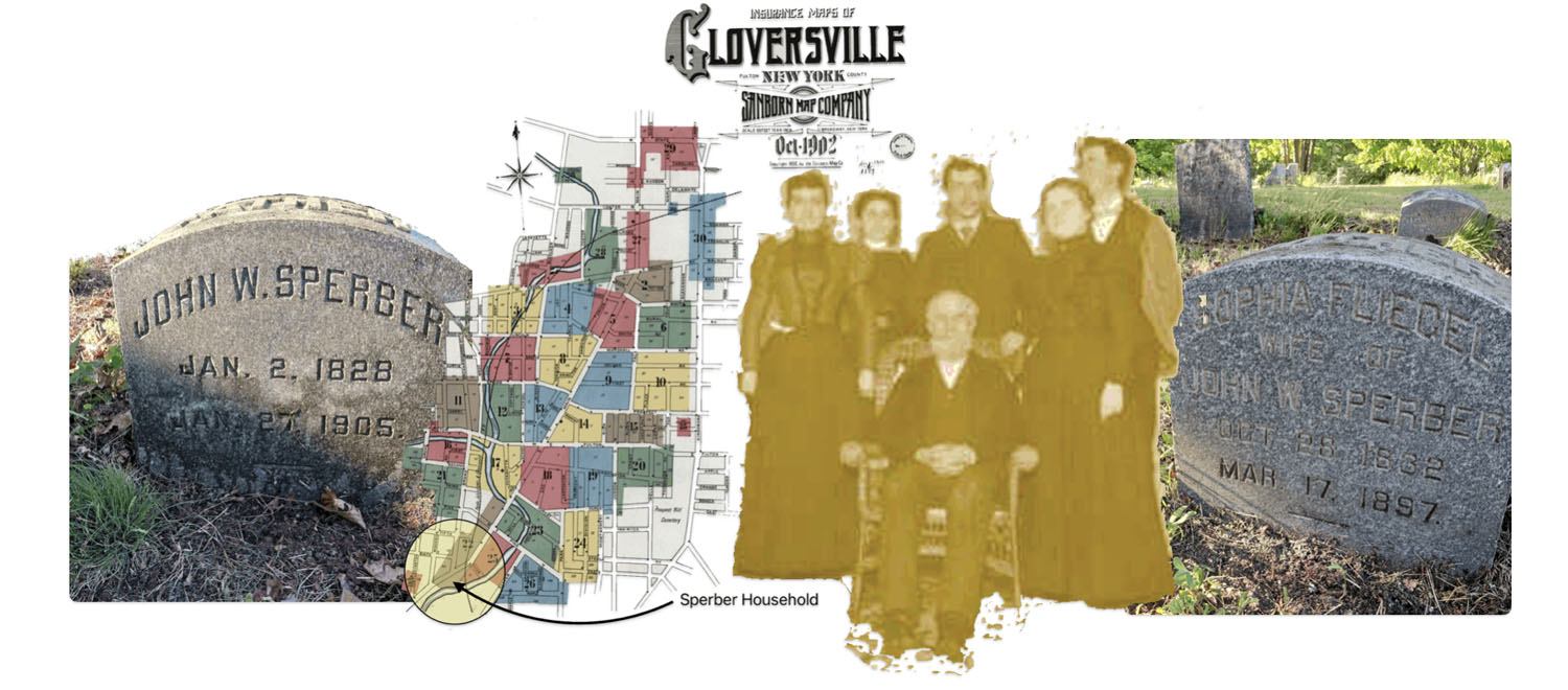
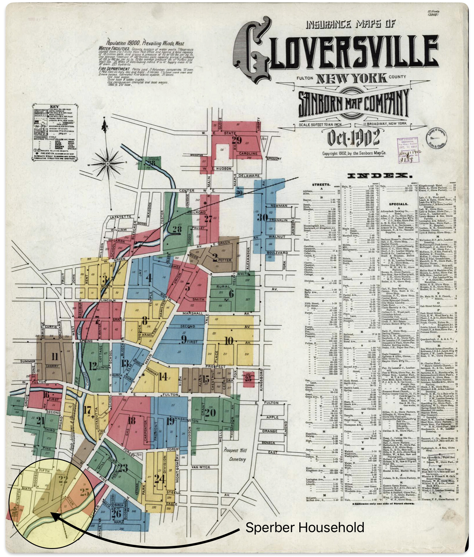
The Sanborn Company produced their distinctive type of maps for Gloversville in 1902 and 1905. Fortunately the address locations of the Sperber households were included in various sections of their Gloversville maps. Map two below is the cover map of the 1902 map series. I have highlighted the area where John and Sophie Sperber lived since 1868.
Map Two: Cover Map of Sanborn Map of Gloversville in 1902
Johann Sperber’s household was located in section 22 of the Sanborn Gloversville map series. Map three below is page twenty-six of the map series. John’s household was located just above the measurement legend on the map in the lower left hand corner.
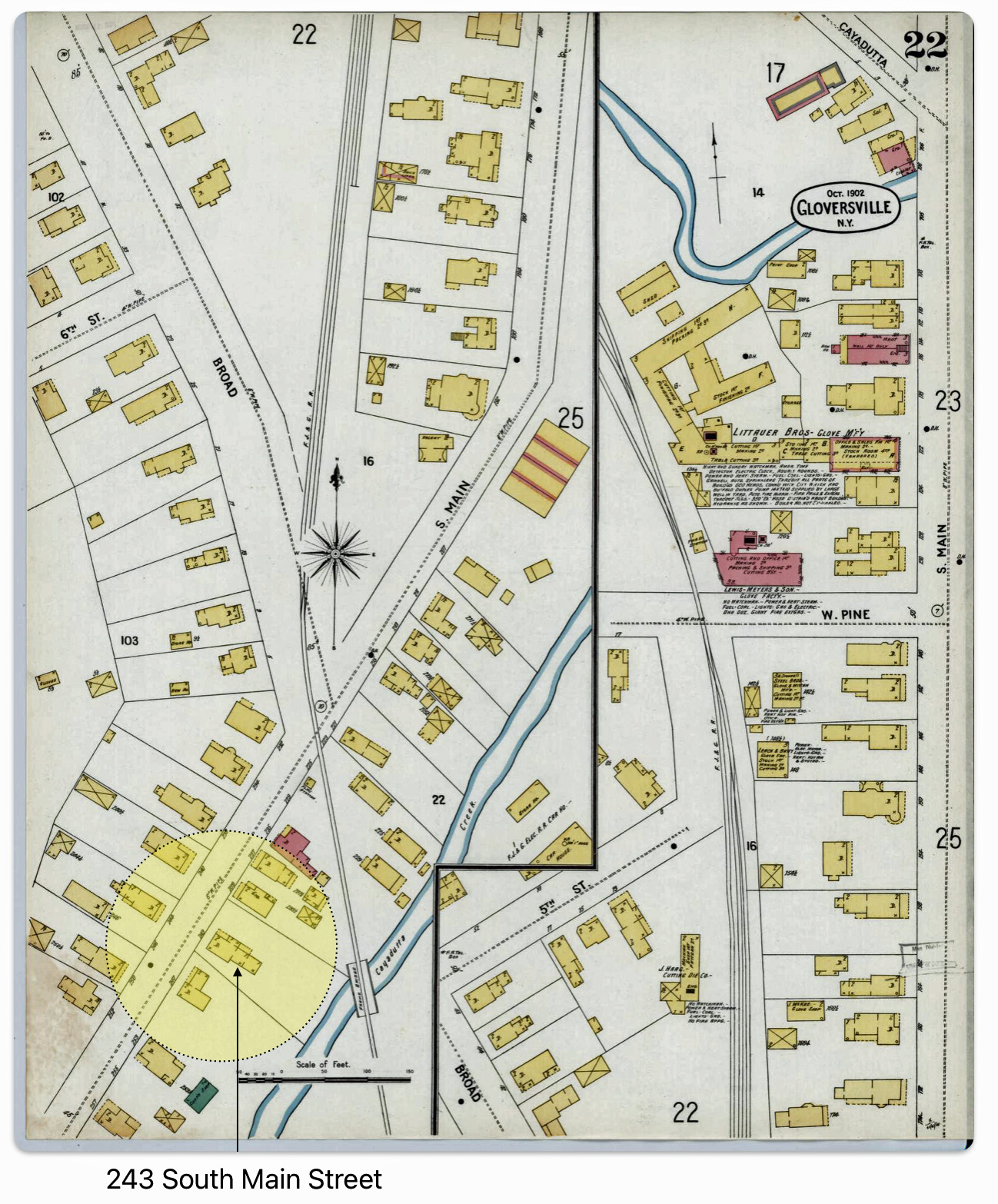
Map Two: 243 South Main Street, Gloversville, NY – Sanborn Fire Insurance Map from Gloversville, Fulton County
A blow up of the lower left hand portion of map six is provided in map three below. Sperber’s household is located in the middle of the blow up map, the back end of the property borders on the Cayadurra Creek. The Fonda, Johnstown and Gloversville Railroad (FJ&G) touches the corner of the back of his property.
Based on the Sanborn color coding, symbols and numbers, John Sperber’s house was a wood frame building with two stories in the front of the house. There were two attached rooms on the back end of the house and a side entrance to the house.
Map Three: Blow Up of Sanborn Map of 243 South Main Street
A correlation of facts found in the 1902 Sanborn Map 22 of Gloversville and in the city directory of 1894 reveals how close the households of the three males in the Sperber family were in Gloversville. See map four below.
The street numbering did not change between 1894 and 1902 in Gloversville, so it is plausible to assume that the address locations listed in the 1894 city directory correspond to the street numbers found in the 1902 Sanborn map.
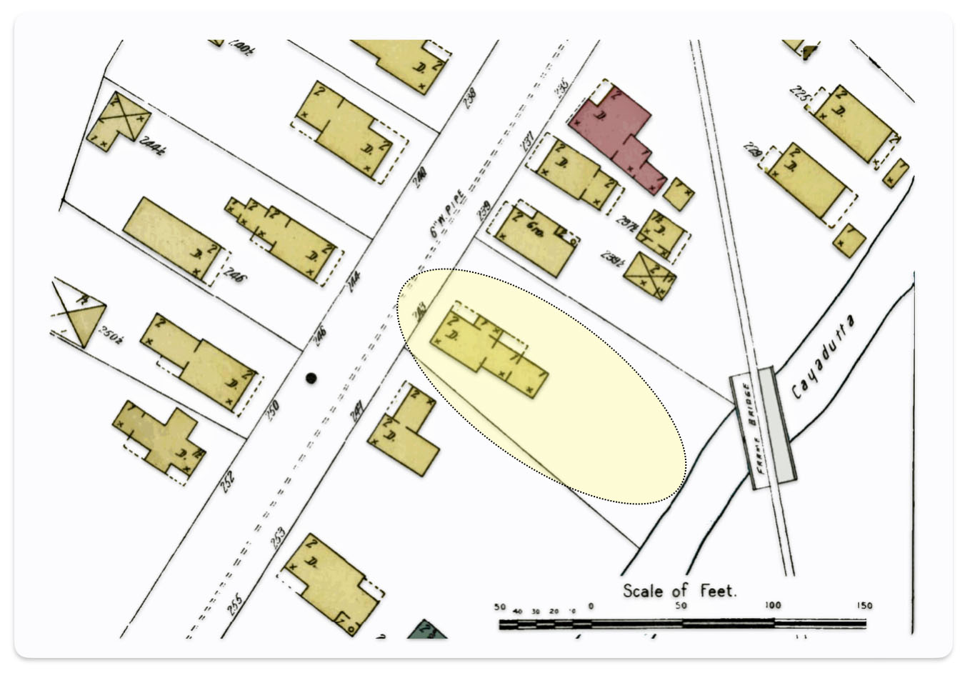
Map Four: Blown Up Portion of a 1902 Sanborn Map 22 of Gloversville Depicting Proximity of Three Sperber Households in 1894
What is striking when looking at map one is the proximity of each of the Sperber family households. John’s eldest son Frederick was living at 13 Broad Street which was close to the intersection of Broad Street and South Main Street. Frederick’s house was the third house from the intersection on Broad Street. John’s house was four house from the intersection on South Main Street. It was a short walk in between the households.
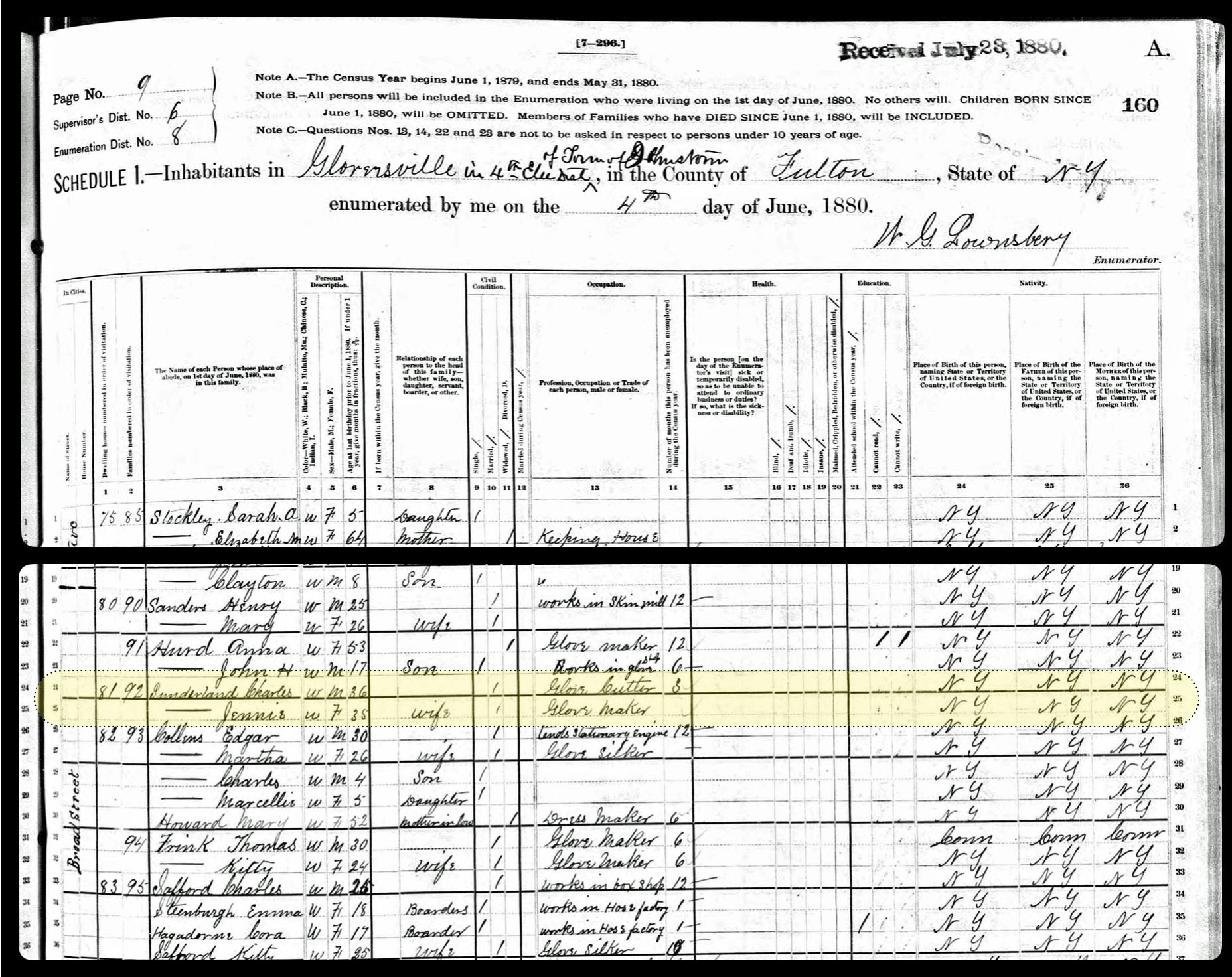
Frederick Sperber’s family was living on Broad Street since 1886. Based on Fulton county land deed documents, they purchased property on Broad Street in Ella Sperber’s name from Andrew D. & Mary C. Simmons. [19] The house was originally occupied by the Sunderlin Family. In the 1880 Federal census documented that the Sunderlin family was the third house on Broad Street. [20] It is not known why the property was placed in Ella’s name.
Frederick and Ella purchased the property when they were both 30 years old. They had three of their four children when they bought the property on November 1, 1886. At the time, their youngest, Frederick John Sperber, was about a month and a half old. He was born September 18th.
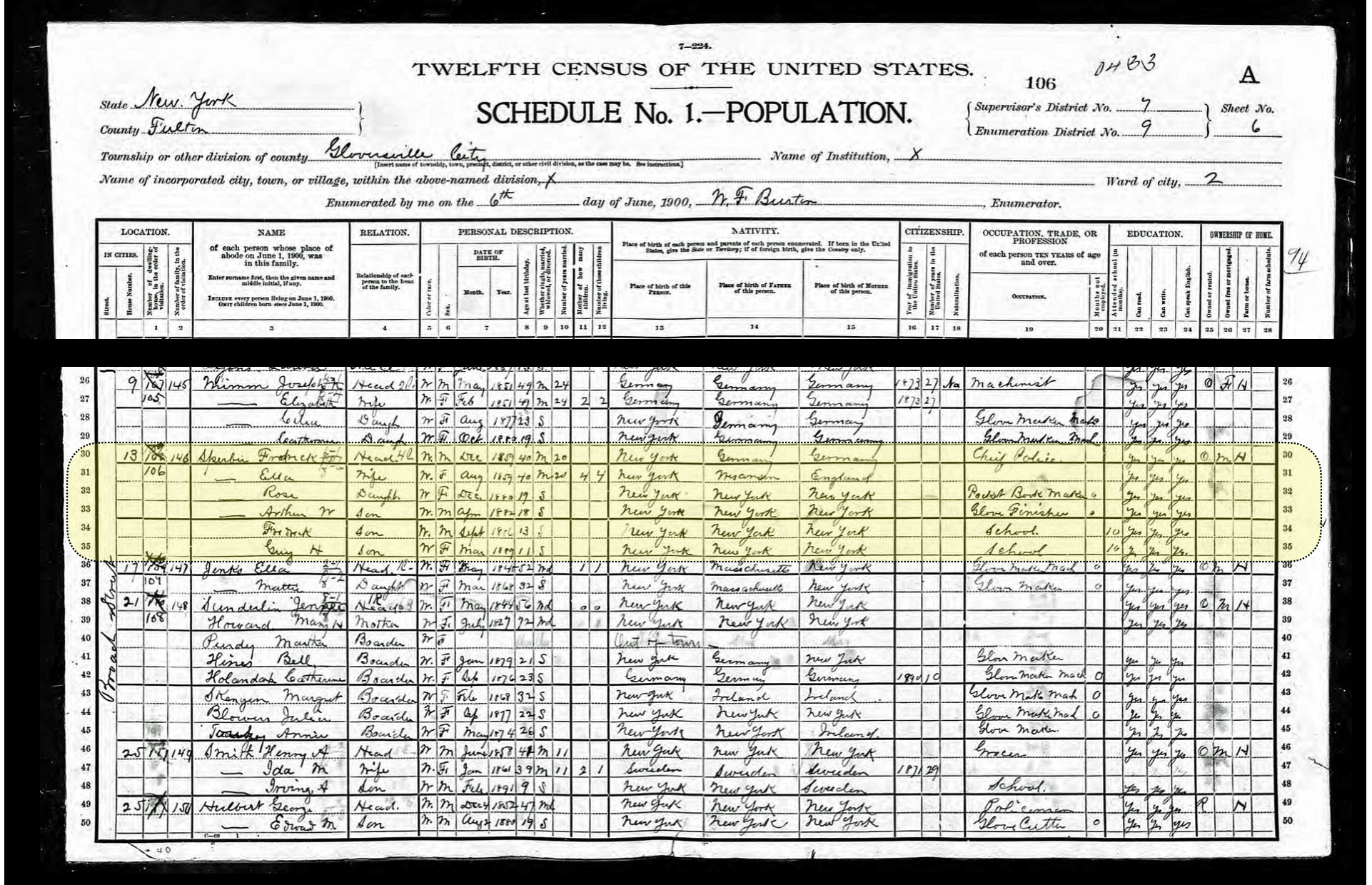
During the 1890s, Frederick, who was the Chief of Police for Gloversville, and his wife Ella had a family of teenagers and toddlers. By the end of the decade Rose, their oldest was 19 years old. Rose was living with her parents and was a pocket book maker. Arthur and Frederick John Sperber were teenagers. Arthur was a glove finisher and his brother was still in school. [21]
Table Two: Frederick Sperber’s Family in the 1890s
Name
Family Relation
Birth Date
Death Date
Age Between 1890 & 1900
Frederick Sperber
Father
1859
1936
31 – 41
Ella (Aucock) Sperber
Mother
1859
1928
31 – 41
Rose M. Sperber
Daughter
1880
1945
10 – 20
Arthur William Sperber
Son
1883
1931
7 – 17
Frederick John Serber
Son
1886
1945
6 – 16
Guy Sperber
Son
1889
1940
1
As reflected in table three below, Louis P. Sperber, John and Sophia’s second son, resided in various places in Gloversville, New York throughout his life. Until he was married, he lived with his father and mother. As previously mentioned, during his first two years of marriage, he and Anna lived across the street from his father at 246 South Main Street. As reflected in map four above, the house was a wooden frame one room house with a porch.
As indicated in image four above, in 1895 he and his wife Anna lived at 3 Woodside Ave. In 1900, he and his wife Ann, lived with her mother Kate Sprung at 14 Washington Street. In 1902 he and Anna lived next door to his mother-in-law , at 14 Washington Street. In 1903, the couple resided at 18 Spring and in 1904 at 32 Elm Street. In 1909 through 1912 Louis and Ann, along with her mother, lived at 25 S School. While it is not known when Ann passed away, Louis P Sperber remarried Rose Clancey in 1913. [22] Louis Sperber died at the age of 51 years on September 15, 1920. [23]
Table Three: Louis P. Sperber – Occupation and Residence Addresses Found in Sampled Gloversville City Directories 1881 to 1903
Year
Age
Occupation
Address
Source
1888
22
Glover Finisher
155 S. Main St.
Gloversville City Directory Page 156
1889
23
Glover
155 S Main St.
Gloversville City Directory Page 147
1890
24
Glover
155 S Main St
Gloversville City Directory Page 155
1891
25
Glover
155 S Main St
Gloversville City Directory Page 168
1894
28
Tanner
246 S Main St
Gloversville City Directory Page 158
1895
29
Tanner
3 Woodside Ave.
Gloversville City Directory Page 165
1900
31
Policeman
14 Washington St.
1900 Federal Census *
1902
33
Policeman
12 Washington St
Gloversville City Directory Page 195
1903
34
Policeman
18 Spring St.
Gloversville City Directory Page 201
1904
35
Policeman
32 Elm St.
Gloversville City Directory Page 189
1909
39
Glover
25 S. School
Gloversville City Directory Page 334
1912
42
Employee Fownes Bros.
25 S. School
Gloversville City Directory Page 307
* 1900, Federal Census, New York, Fulton County, Gloversville, Ward 01, District 0007, Page 16, Lines 34-36
The following map five illustrates the various places listed in table two for the various residence addresses where Louis Sperber lived.
Map Five: Location of Various Places Where Louis P. Sperber Lived in Gloversville, N.Y.
John Sperber was living three doors down from the household of his brother-in-law, Louis Knoff. As mentioned in prior parts of this story, Louis Knoff had a successful tanning business and was married to Sophia (Fliegel) Sperber’s sister Rosa (Rose) Fliegel. Louis Knoff established his tanning business along the Cadayutta Creek on South Main Street in 1865.
While the Sperbers lived in wood framed houses, the Knoff family lived in a brick house. This can be discerned by examining the Sanborn map in map four above. The structure located at 235 South Main Street is color coded in red. Color plays an important role in the Sanborn maps. Brick and tile structures are represented with a reddish/pink color while the use of yellow indicates frame, or wood, structures. [24]
1897: Marriage and Death in the Family
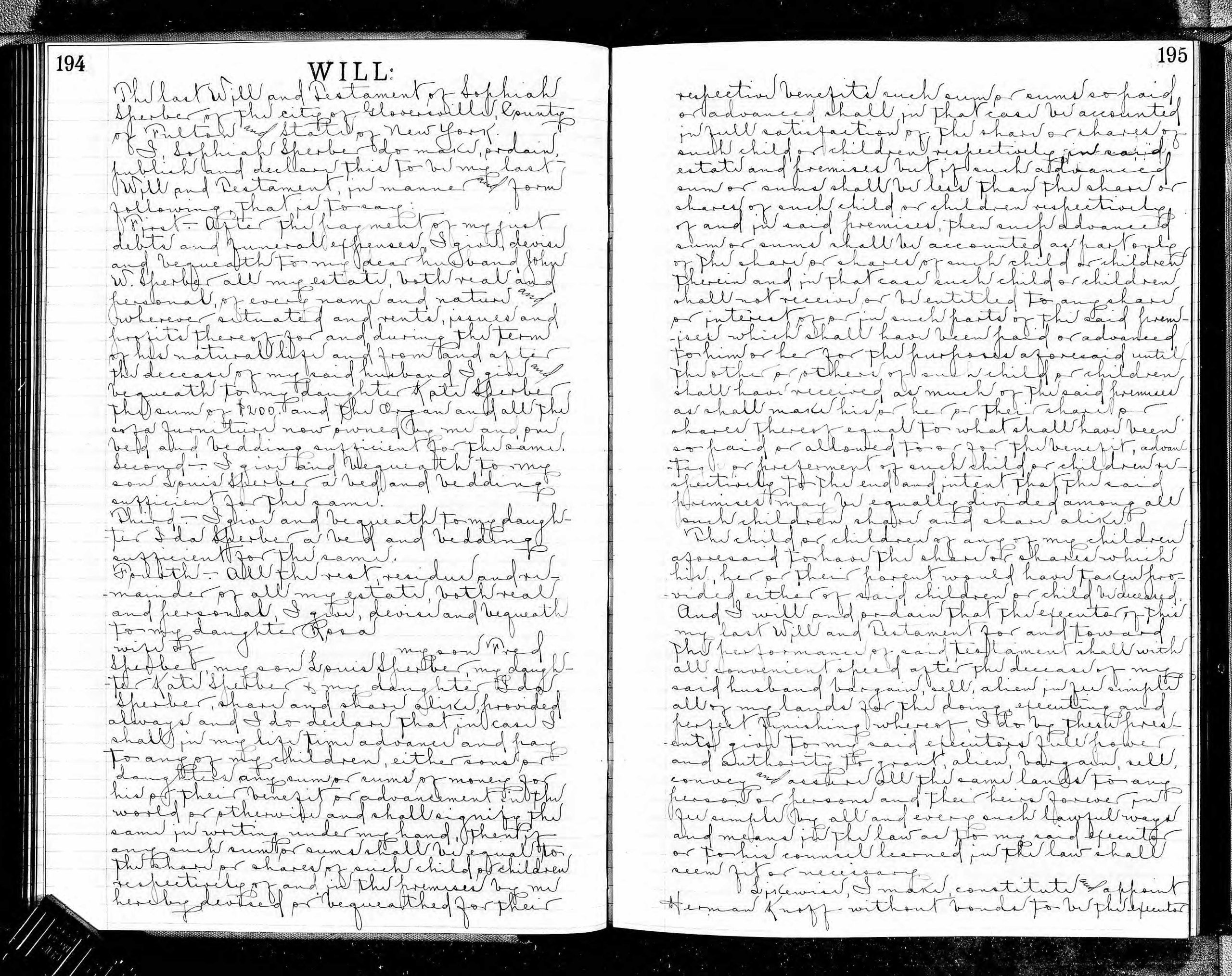
Four years before her passing, Sophia Sperber created or updated her last Will and Testament on April 19th, 1893. She made her nephew, Herman Knoff, the executor of her will. [25]
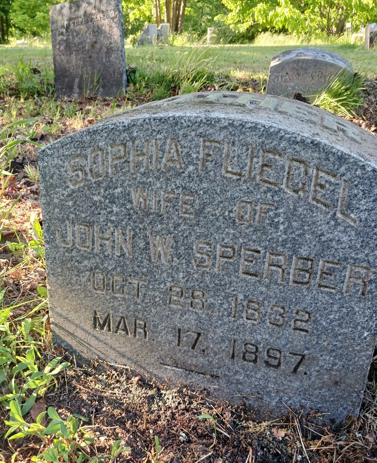
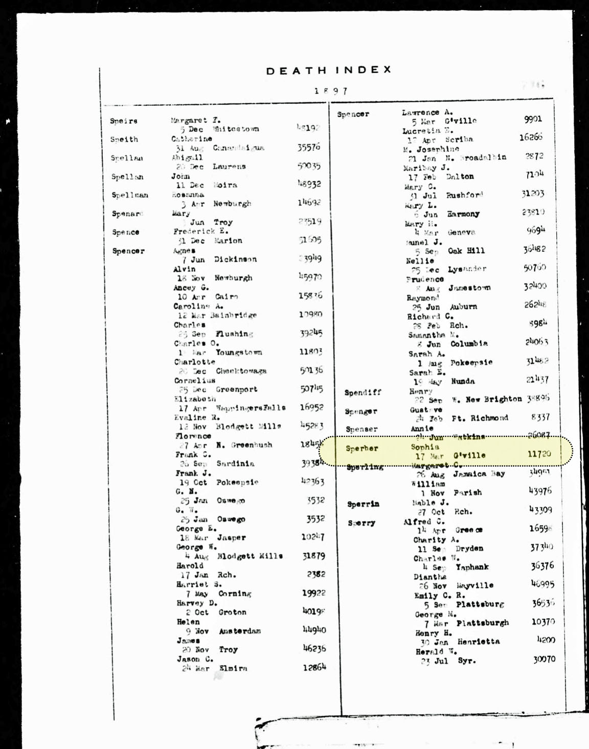
Sophia passed away on March 17, 1897. She was 65 years and five months old. Sophia was buried in Prospect Hill cemetery in Gloversville, New York. [26]
Headstone of Sophia Fliegel “Wife of John W. Sperber“
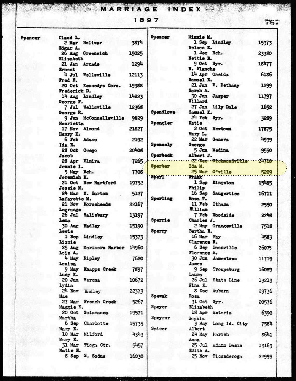
Eights days after her passing, Sophia’s youngest daughter, Ida Sperber, married Charles Griffis on March 25, 1987 in Gloversville. [27]
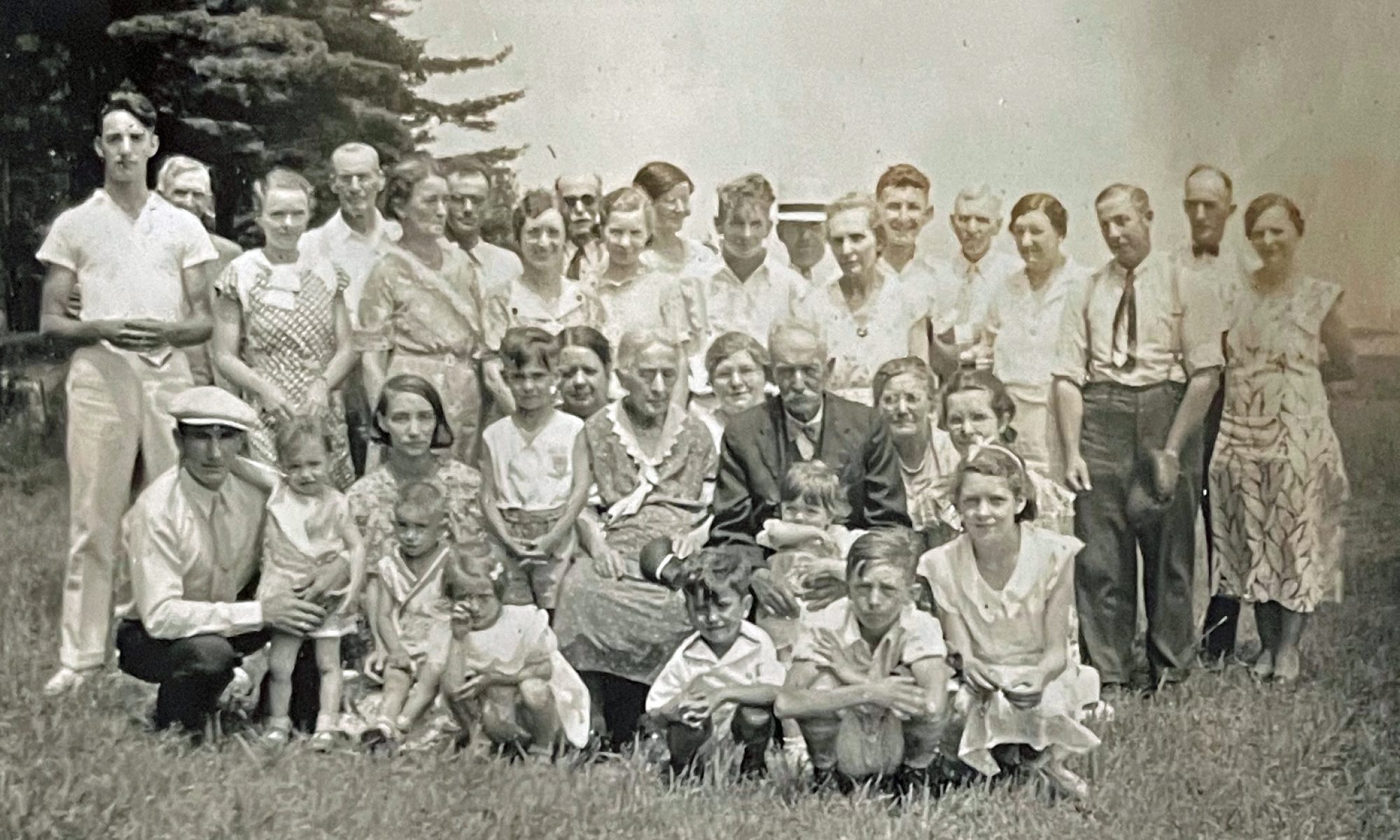
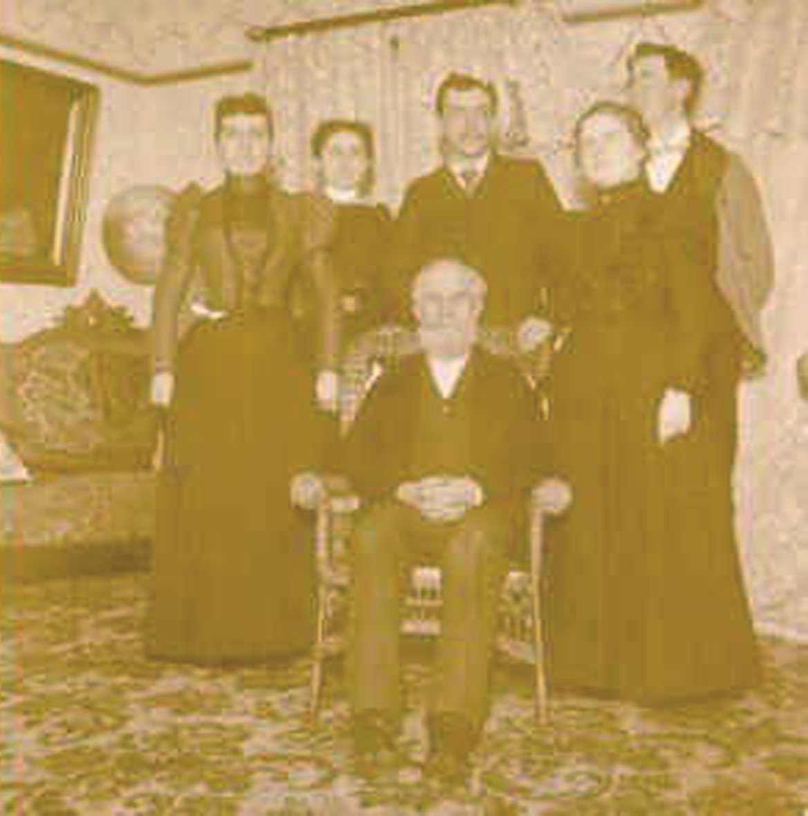
The following photograph was taken towards the end of the decade: on March 14, 1898. In one of only three existing photographs of John Sperber, John Sperber is sitting in the center of the photograph, presumably in his home. John Sperber was 69 years old. Standing behind him are, from left to right, Ann Sprung (Age 22), Katherine (Kate) Sperber (age 33), Lewis Sperber (age 28, Ann’s husband), Ida Sperber (age 21) and Charles Griffis (age 20).
Sperber Family Gathering March 14, 1898
Source: Family Collection. On the back of the photograph was the following handwritten statement: Left to right: Kate Sperber, unknown, unknown, Ida Griffis, Charles Griffis, center – Grandfather Sperper, 03-14-1898 | Click for Larger View
The photograph documents and reflects a pivotal time in the Sperber family. Sophia the matriarch of the family passed away a year before on March 17, 1987. Ida Sperber married Charles Griffis on March 25, 1987.
The Turn of the Century: the 1900s
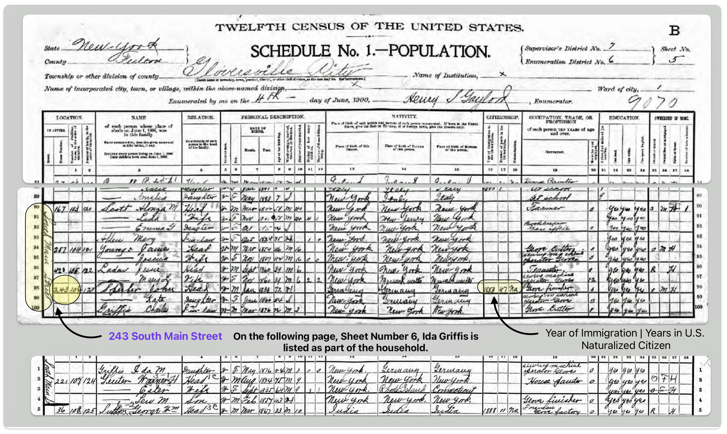
In 1900, John Sperber was around 72 years old, widowed; and living other family members at 243 South Main Street, Gloversville, New York. The household consisted of John along with his daughter Kate and his youngest daughter Ida and her husband Charles Griffis.
“In every census year between 1850 and 1900, over 75 per cent of elderly men residing with a child were listed as the household head. This suggests that in multigenerational households including elderly men, the older generation ordinarily retained authority. It is doubtful that many of these elderly men had moved in with their children because they could no longer support themselves ; it is far more plausible that the younger generation remained in the parental household after reaching adulthood. “[28]
John Sperber Household in 1900
Click for Larger View | Source: 1900 U.S. Federal Census New York, Fulton County, Gloversville Ward 1, Fulton, New York; Roll: 1036; Page: 5; Enumeration District: 0006 Page 5 Lines 98 – 100 & Page 6 Line 1
At the age of 75, John Sperber was still listed in the Gloversville Directory as a glover, living in the same house he raised his family in the late 1860s. His oldest son, the Chief of Police of Gloversville, Frederick, lived right around the corner. Frederick’s son, Arthur Sperber, living with his father, was a conductor for the railroad.
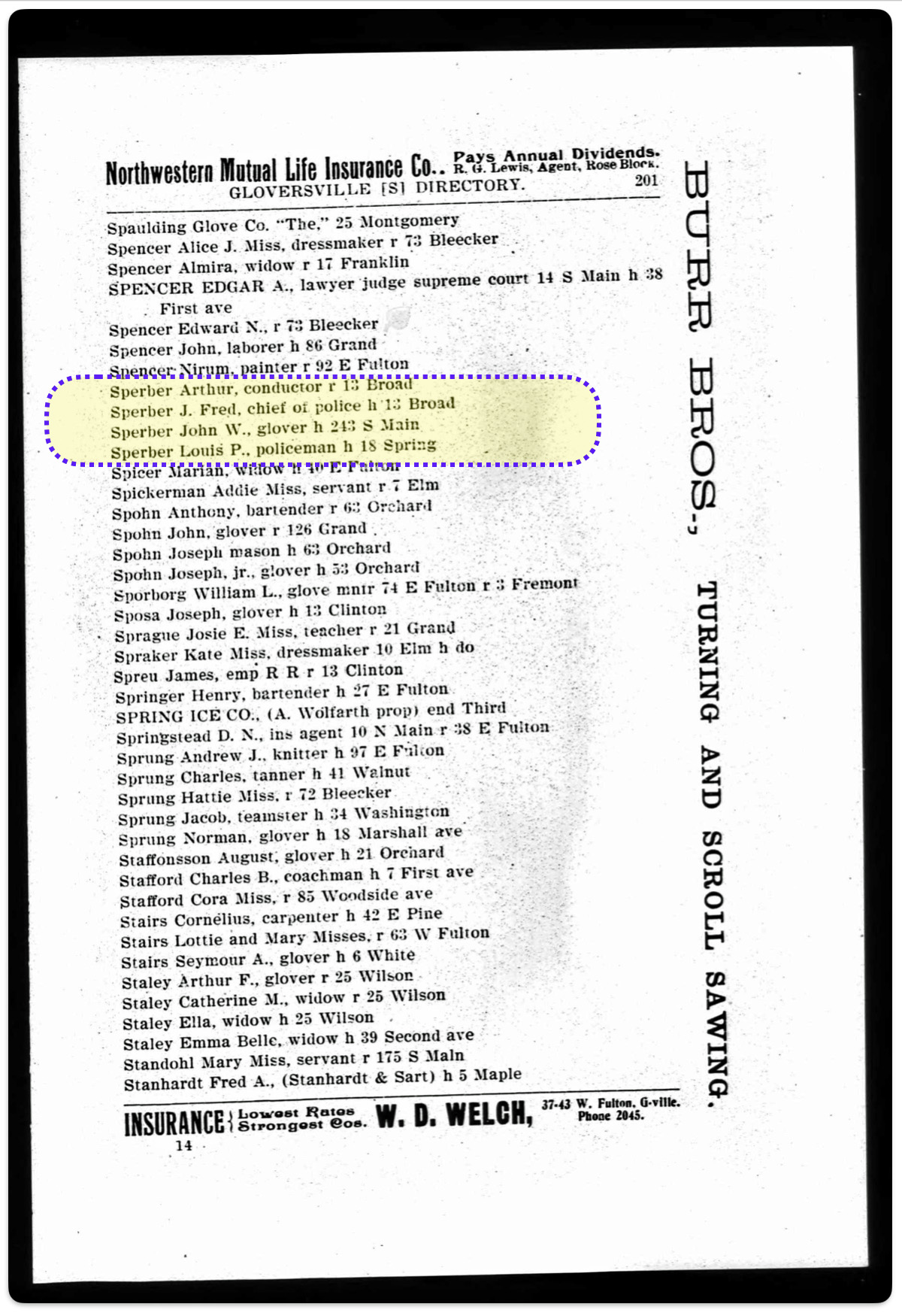
1903 Gloversville City Directory
Click for Larger View | Source: Gloversville City Directory 1903, O. .H. Bame & Co., Page 201
On June 29th, 1903, Harold Griffis was born. His parents Charles Griffis and Ida (Sperber) Griffis lived with John Sperber at the time of his birth.
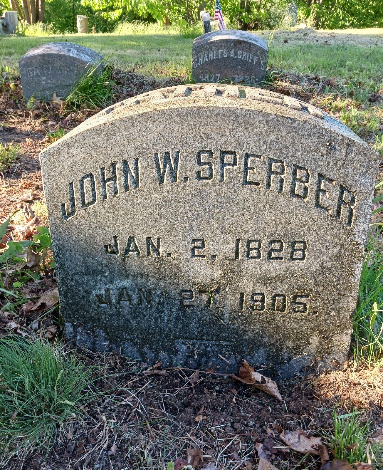
John Wolfgang Sperber passed away on January 27th, 1905, twenty-five days after his 77th birthday. Harold Griffis was one year and a half years old when his grandfather passed away. It is not known what was his cause of death.
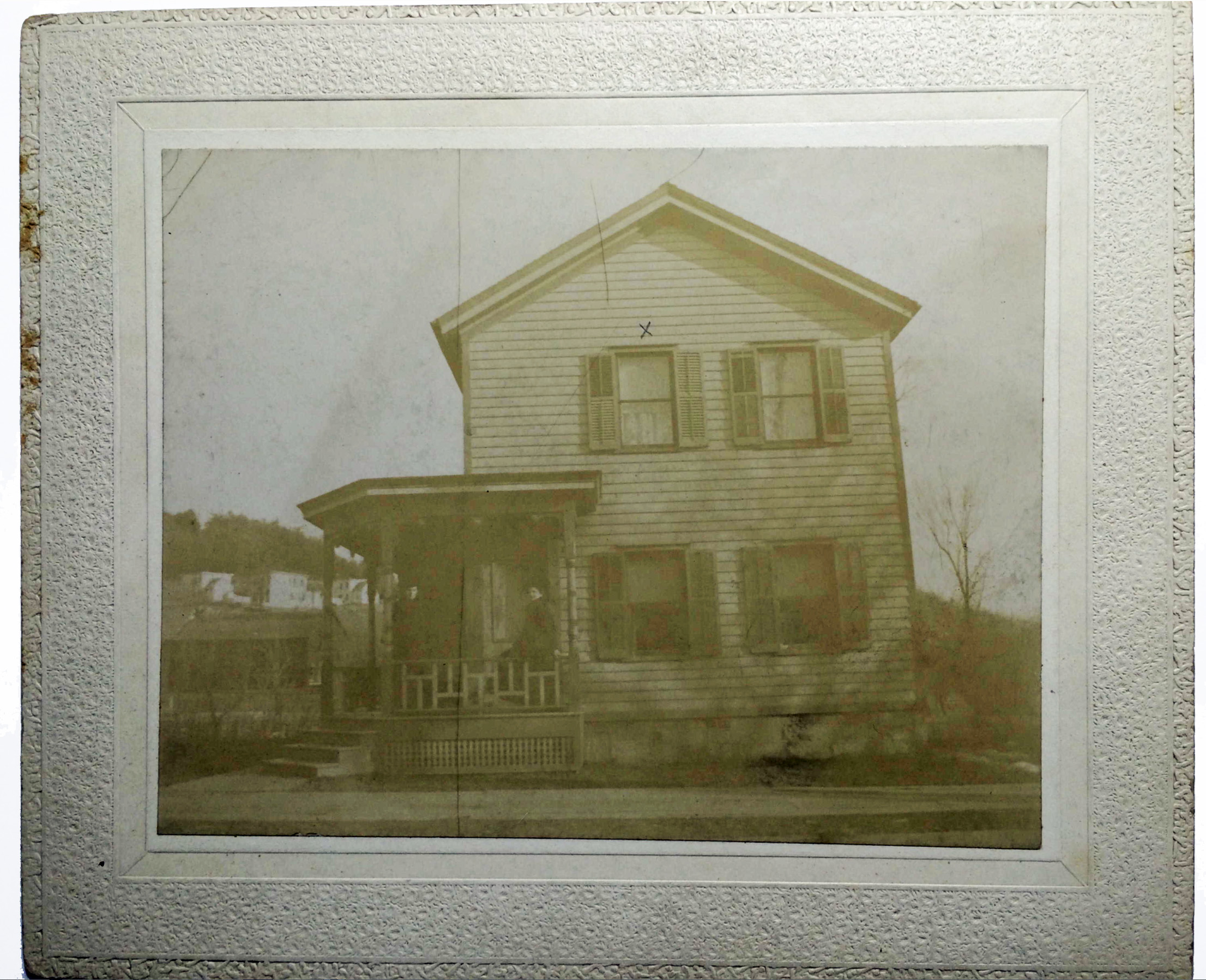
The following photograph is an undated photograph of the house located at 243 South Main Street. On the back of the photograph, a handwritten note indicates: “Room in upper left is where Harold was born”. An ‘X’ was made on the photograph to indicate the location of Harold’s birth on the second floor. It is presumed that the two individuals on the porch of the house are Charles Griffis and Ida (Sperber) Griffis.
Birthplace of Harold Griffis – 243 South Main Street
Below is a photograph of his headstone. John or Johann was buried beside his wife Sophia in Prospect Hill cemetery, Gloversville, New York. It is interesting to note that the headstone of his son-law, Charles A. Griffis, is in the background. Charles was the father of Harold Griffis.
Headstone of John Wolfgang Sperber – Inscription on Top: “Father”
John Wolfgang Sperber lived a long and full life. Perhaps for a number of reasons, he chose to leave his homeland on the Rhine River and create a new life in America. He found Sophie Fliegel and they raised a family in the thriving city of Gloversville. John Wolfgang Sperber and his wife, Sophia Fliegel, had six children; seven grandchildren; and five great grand children.
They had two sons, John Frederick Sperber and Louis P Sperber. Louis did not have any sons. John Frederick, however, had three sons: Arthur J Sperber, Frederick John Sperber, and Guy Sperber. None of the three grandsons had any sons to carry the Sperber name forward. Of the remaining Sperbers, Ida Sperber was the last member of the Sperber family. Ida May (Sperber) Griffis died in 1954.
Despite the surname not continuing through future generations, the remaining descendants of John Sperber are represented through his grandson Harold Griffis. Through Harold Griffis, he has four great grandchildren, eight great2 grandchildren, fourteen great3grandchildren, and seven great4grandchildren.
Sources
Feature Photograph: The banner for this story is an amalgam of old and new photographs and a map. The photographs on each end of the banner are of the headstones for John and Sophia Sperber. The middle photograph is from an 1898 family photograph of the Sperber family at John’s house. The 1902 map of Gloversville shows the location of John’s house that he lived in for over thirty years.
[1] Barbara McMartin, The Glove Cities: How A People and Their Craft Built Two Cities, NY: Lake View Press, 1999, Page 59
[2] The economy of the United States in the 1890s was marked by a severe depression known as the Panic of 1893, followed by a period of recovery and growth in the latter part of the decade.
Economic Boom and Industrialization: The late 19th century saw rapid industrialization and economic growth in the U.S. This economic transformation made the U.S. a leading industrial power by the end of the century. However, the gains were not evenly distributed, exacerbating economic inequality. Key developments included:
Expansion of railroads, linking the country and enabling the growth of national markets
Rise of large-scale manufacturing, with output doubling between 1870 and 1890
Technological innovations like the lightbulb, telephone, and new manufacturing processes
Growth of corporate America and new management systems for large-scale operations
Shift from an agricultural to industrial economy, with manufacturing surpassing agriculture’s share of the labor force
The Panic of 1893 and Economic Depression: Despite the overall growth trend, the 1890s were punctuated by a severe economic depression.
The Panic of 1893 led to a major contraction in investment, commerce, prices, and employment lasting several years;
Unemployment rose from around 3% in 1892 to 19% in 1894, with over 3 million Americans out of work at the peak; It led to immense hardship for workers and farmers;
Thousands of businesses, including major railroads, failed; banks collapsed, farm foreclosures surged; and
Causes included speculation in railroads, shaky finances, and a run on gold spurred by European concerns.
Social and Political Upheaval: The economic turmoil of the 1890s fueled social unrest and political challenges to the status quo. The decade saw the existing two-party system strained by demands for change and a realignment in the 1896 election. The depression exposed the need for new policies to regulate the industrial economy and provide social protections.
Major strikes like the Homestead and Pullman strikes reflected growing labor militancy;
The Populist Party surged, channeling discontent and proposing economic reforms;
Marches by unemployed workers like Coxey’s Army demanded government jobs programs; and
Farmers faced falling prices and heavy debt burdens, losing land to foreclosures.
[3] Barbara McMartin, The Glove Cities, Page 59 – 60
[7] City directories from the mid to late 1800s provide a valuable record of urban populations and businesses during a time of rapid growth and change in American cities. They are frequently used by:
Genealogists and family historians to locate ancestors;
Historians studying the development of cities and businesses; and
Demographers analyzing urban population patterns
Although not fully comprehensive in terms of sampling, data coverage or reliability, city directories offer a unique snapshot of the economic and social makeup of American cities throughout the 19th century.
Rose-Redwood, Ruben S., Indexing the great ledger of the community: urban house numbering, city directories, and the production of spatial legibility, Journal of Historical Geography, Volume 34, Issue 2, 2008, Pages 286-310, https://doi.org/10.1016/j.jhg.2007.06.003
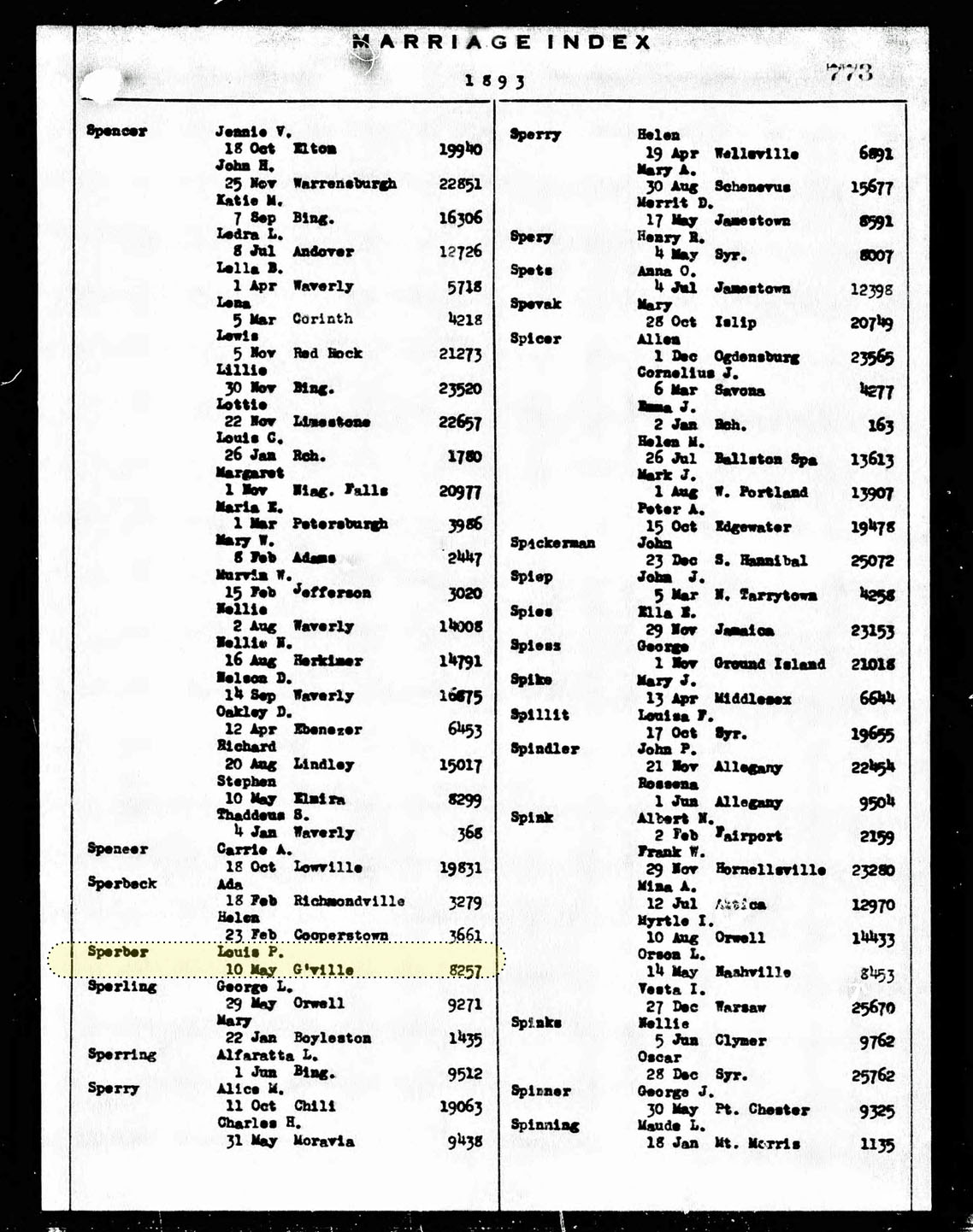
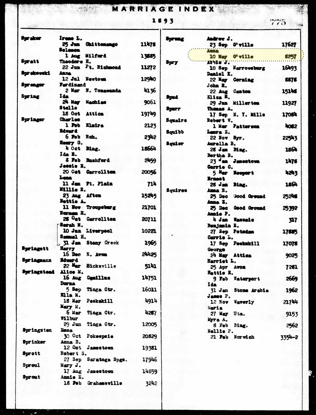
[13] Marriage index documenting marriage of Louis P. Sperber and Anna Sprung on 10 May 1893 in Gloversville, New York:
Click for Larger View | Source: Source: New York State Marriage Index, 1881 – 1967, 1893, Page 775 Louis P Sperber and Page 775 Anna Sprung, marriage certificate. number 8257
Click for Larger View | Source: New York State Marriage Index, 1881 – 1967, 1893, Page 775 Louis P Sperber and Page 775 Anna Sprung, marriage certificate. number 8257
[14] Birth of Marguerita Sperber, August 5, 1984, New York State Department of Health; Albany, NY, USA; New York State Birth Index, 1984, Page 814
The following is an obituary notice for Louis and Anna’s daughter.
Source: The daily leader., April 19, 1895, Page 8, Gloversville, NY
[15] In the late nineteenth century, epidemics of cholera, typhus, yellow fever, smallpox, whooping cough and diphtheria claimed many lives, and endemic infectious diseases took a significant toll on infants and young children.
Preston, Samuel H. and Michael R. Haines, The Social and Medical Context of Child Mortality in the Late Nineteenth Century, in Samuel H. Preston and Michael R. Haines, ed, Fatal Years: Child Mortality in Late Nineteenth-Century America, Princeton University Press, January 1999, Pages 3 – 48; Volume URL: http://www.nber.org/books/pres91-1 ; Chapter URL: http://www.nber.org/chapters/c11541
Leavitt, Judith W., “Politics and Public Health: Smallpox in Milwaukee, 1894-1895.” Bulletin of the History of Medicine, vol. 50, no. 4, 1976, pp. 553–68. JSTOR, http://www.jstor.org/stable/44450375
[16] There are a few key studies that have correlated historical city directories with maps to analyze urban areas in the United States in the late 19th century:
For example, the Urban Transition Historical GIS Project used data from the 1880 U.S. Census along with historically accurate GIS maps showing the boundaries of enumeration districts in 39 major cities. They geocoded addresses of households from the census records, which enabled spatial analysis of residential patterns at various geographic scales. The project used historical city directories from the period as a major source, providing detailed street maps, ward boundaries, and lists of streets with address ranges. This allowed the researchers to trace street name changes over time and determine address ranges even when not explicitly listed in the directories.
Logan JR, Jindrich J, Shin H, Zhang W. Mapping America in 1880: The Urban Transition Historical GIS Project. Hist Methods. 2011 Jan 1;44(1):49-60. doi: 10.1080/01615440.2010.517509. PMID: 21475614; PMCID: PMC3070308. https://www.ncbi.nlm.nih.gov/pmc/articles/PMC3070308/
Another case study looked at using old maps and city directories together to research the history of a 19th century home. Even though street names, addresses and city boundaries changed over time, the combination of period maps and directories enabled the researcher to trace the history of the property
The Mapping America in 1880 paper provides more detail on the methodology used by the Urban Transition Historical GIS Project. In cases where city directories did not provide address ranges, they determined the range of addresses of residents along a street within enumeration district boundaries, and estimated their locations using linear interpolation. Multiple iterations were done, estimating boundaries, geocoding addresses, then correcting errors, to achieve a high degree of accuracy in mapping historical enumeration district boundaries and household locations in late 19th century U.S. cities.
John Logan, Jason Jindrich, Hyoungjin Shin, Weiwei Zhang, Mapping America in 1880 The Urban Transition Historical GIS Project, Database Developments, Historical Methods, January-March 2011, Volume 44, Number 1, Pages 49 – 60, Mapping America_Hist Methods 2011.PDF
[17] Founded in 1867 by Daniel Alfred Sanborn, the company created richly detailed maps of approximately 12,000 cities and towns across the United States, Canada, and Mexico.Sanborn maps were originally designed to assist fire insurance companies in assessing the risk associated with insuring a particular property.
The Sanborn Company sent out legions, or to use the collective group term of surveyors, ‘chains’, of surveyors to map building footprints and collect urban data. At its peak in the 1920s, the company employed about 700 people, including 300 field surveyors and 400 cartographers, printers and managers. Sanborn held a virtual monopoly over fire insurance maps for much of the 20th century after acquiring its last major competitor in 1916.
While originally created for insurance purposes, Sanborn maps have become invaluable historic resources. They allow researchers to trace urban development and changes over time, providing unparalleled detail about the built environment of American cities from the late 1800s through the mid-1900s. The Library of Congress holds the largest collection of Sanborn maps, which are widely used by historians, architects, genealogists and others.
[18] Key for interpreting Sanborn fire insurance maps
Click for Larger View | Source: Colors and Symbols,Interpreting Sanborn Maps, Library of Congress, https://guides.loc.gov/fire-insurance-maps/sanborn-interpreting
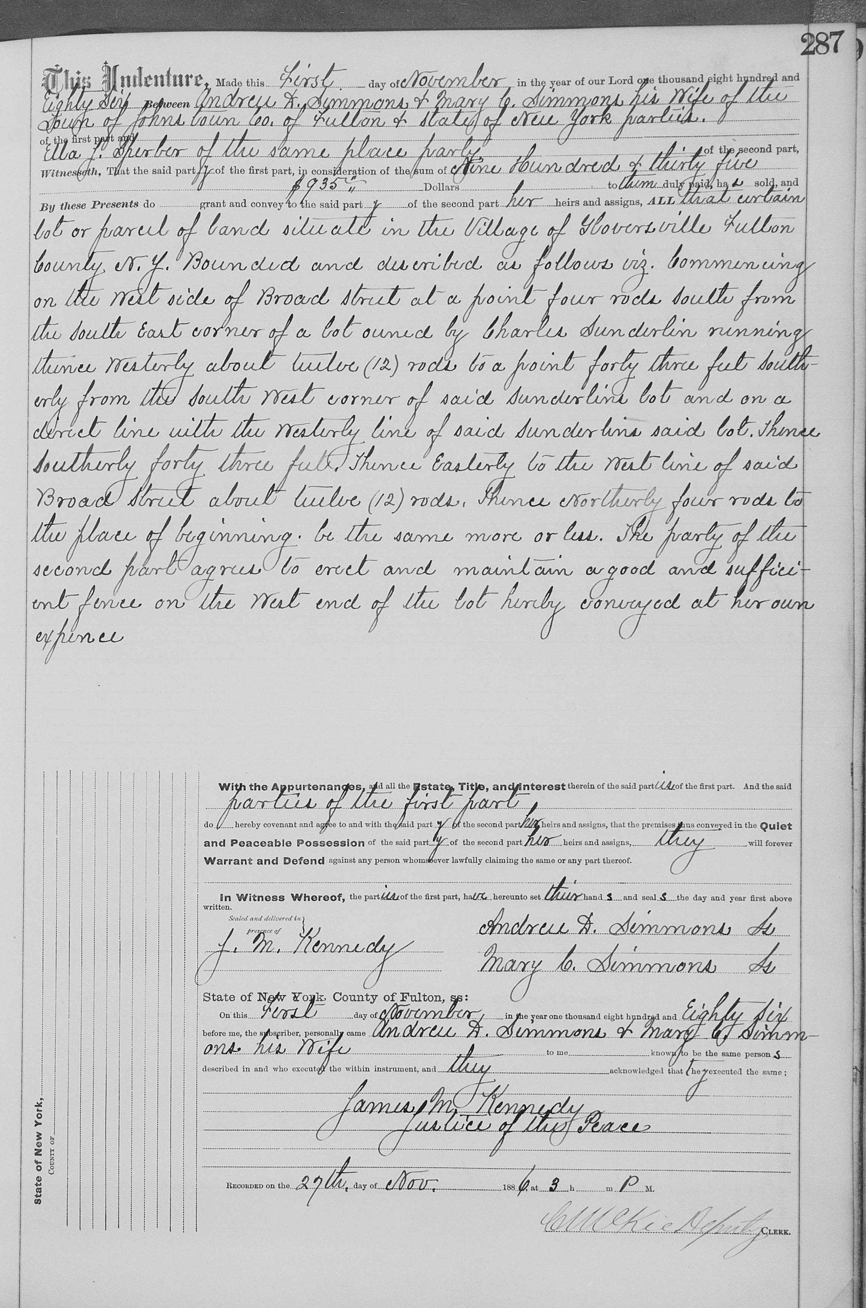
[19] Ella Sperber, Grantee, Andrew D. Simmons, Grantor, 27 Nov 1886, Entry Number 68, page Number 287, Index of deeds, Fulton County, New York, page 689, line 9
New York Land Records, Fulton County, Deeds 1886 – 1887, Vol 68 , Page 287
Transcript of Deed
This indenture, Made this first of November in the year of our Lord one thousand eight hundred and eighty Six between Andrew D. Simmons & Mary C. Simmons his wife of the Town of Johnstown Co. of Fulton & State of New York parties of the first part and Ella J. Sperber of the same place part of the second part, Witnesseth, That the said party of the first part, in consideration of the sum of nine hundred and thirty five $935.00 dollars to them duly paid, has sold, and By these Presents do grant and convey to the said party of the second part her heirs an assigns ALL that certain lot or parcel of land situated in the Village of Gloversville Fulton County N.Y. Bounded and described as follow viz. Commencing on the West side of Broad Street at a point four rods south from the South East corner of a lot owned by Charles Sunderlin running thence Westerly about twelve (12) rods to a point forty three feet Southerly from the South West corner of said Sunderlins lot and on a direct line with the Westerly line of said Sunderlins said lot. Hence Southerly forty three feet. Thence Easterly to the West line of said Broad Street about twelve (12) rods. Thence Northerly four rods to the place of beginning, be the same more or less. The party of the second part agrees to erect and maintain a good and sufficient fence on the West end of the lot hereby conveyed at her own expense.
[Recorded on the 27th day of Nov. 1886]
The Original Deed
Click for Larger View | Source: New York Land Records, Fulton County, Deeds 1886 – 1887, Vol 68 , Page 287
[20] Charles and Jennie Sunderlin (Sunderland), 1880 U.S. Federal Census, Fulton County, Gloversville, Page 9, Enumeration District 8, Line 24-25; the Sunderlin Household in 1880:
Click for Larger View | Source: Charles and Jennie Sunderlin (Sunderland), 1880 U.S. Federal Census, Fulton County, Gloversville, Page 9, Enumeration District 8, Line 24-25
[21] Frederick Sperber Household, 1900 Federal Census, New York, Fulton County, Gloversville Ward 02, District 0009, Page 6, Lines 30 -35
Click for Larger View | Source: Frederick Sperber Household, 1900 Federal Census, New York, Fulton County, Gloversville Ward 02, District 0009, Page 6, Lines 30 -35
[22] New York State Marriage Index, 1913, page 6164, May 28, 1913, certificate number 10165.
[23] Louis P. Sperber, New York Department of Health; Albany, NY; NY State Death Index, 1920 certificate number 54031
“Louis P. Sperber, a life-long resident of Gloversville, died at his home following a lingering illness. Louis was the son of John W. and Sophia (Fliegel) Sperber. Louis was first married to Anna Sprung. After her death, he married Rose Clancy. He was a leather worker, a former member of the police force and a member of the Republican City committee from the third district of the sixth ward.“
“Besides his wife, Rose, he is survived by one brother, former Police Chief Fred Sperber, of Gloversville: three sisters, Rose Knopf of Brooklyn, Catherine Sperber and Ida M Griffis of Gloversville; one niece, Mrs. Rose Jennison of Rural Grove and four nephews. “
[25] Sophia Sperber, Wills, Vol 015, 1893-1901, Probate Records, 1789-1955; General Index, 1830-1967; Author: New York. Surrogate’s Court (Fulton County), pages 193 – 196, PDF copy
The following is Sophie Sperber’s Will and Testament. It is interesting that the handwritten will identifies Sophia as ‘Sophiah’. It is not known who actually wrote the will in the ledger.
Click for Larger View | Source: Last Will and Testiment of Sophiah Sperber, New York Wills and Probate Records, 1659 – 1999, Fulton County, Wills, Vol 015, 1893 – 1901, Pages 194 – 196
Click for Larger View | Source: Last Will and Testiment of Sophiah Sperber, New York Wills and Probate Records, 1659 – 1999, Fulton County, Wills, Vol 015, 1893 – 1901, Pages 194 – 196
The following is a transcribed version of the will:
The last will and testament of Sophiah Sperber of the city of Gloversville, Count of Fulton, and State of New York. I Sophiah Sperber do make, ordain, publish and declare this to my heart Will and Testament, in manner and form following, that is to say: First – After the payment of my just debts and funeral expenses, I give devise and bequeath for my dear husband John W. Sperber all my estate, both real and personal, of every name and nature, and whoever situated and rents, issues, and profits thereof for and during the term of his natural life and from and after the decease of my said husband I give and bequeath to my daughter Kate Sperber the sum of $200. and the organ and al the sofa furniture now owned by me and our bed and bedding sufficient for the same.
Second – I give and bequeath to my son Louis Sperber a bed and bedding sufficient for the same.
Third – I give and bequeath to my daughter Ida Sperber a bed and bedding sufficient for the same.
Fourth – All the rest, residue and remainder of my estate both real and personal, I give, devise and bequeath to my daughter Rosa wife of [blank] my son Fred Sperber, my son Louis Sperber, my daughter Kate Sperber & my daughter Ida Sperber, share and share alike, provided always and I do declare that in case I shall in my lifetime advance and pay to any of my chidren, either sons or daughters any sum or sums of money for his or their benefit or advancement in the world or otherwise and shall signify the same in writing under my hand, then if any such sum or sums shall be equal to the share or shares of such child or children respectively of and in the premises by me hereby devised or bequeathed for their
Page two respective benefits such sum or sums so paid or advanced shall in that case be accounted in full satisfaction of the share or shares of such child or children respectively in said state and premises but if such advanced sum or sums shall be less than the share or shares of such child or children respectively of and in said premises, then such advanced sum or sums shall be less than the share or shares of such child or children respectively of and in said premises, then such advanced sum or sums shall be accounted as part only or the share or shares of such child or children therein and in that case such child or children shall not receive or be entitled to any share or interest of or in such parts or the said premises which shall have been paid or advanced for him or her for the purposes aforesaid until the other or others of such child or children shall have received as much or the said premises as shall make his or her or their share or shares thereof equal to what shall have been so paid or allowed for or for the benefit, advantage or preferment of such child or children or efectively for the end and intent that the said premises may be equally divided among all such children share and share alike.
The child or children or any of my children aforesaid to have the share or shares which hi, her, their parent would have ? provided either of said children or child be deceased. And I will and ordain that the executor of this my last Will and Testament for and toward the performance of said testament shall with all convenient speed after the decease of my said husband bargain, sell, alien in fee simple all of my lands for the doing, executing and perfect finishing whereof, I do by these presents give to my said executors full power and authority to grant, alien, bargain, sell, convey and assume all the same lands to any person or persons and their heirs forever in fee simple by all and every such lawful ways and means in the law as to my said executor or to his counsel learned in the law shall seem fit or necessary.
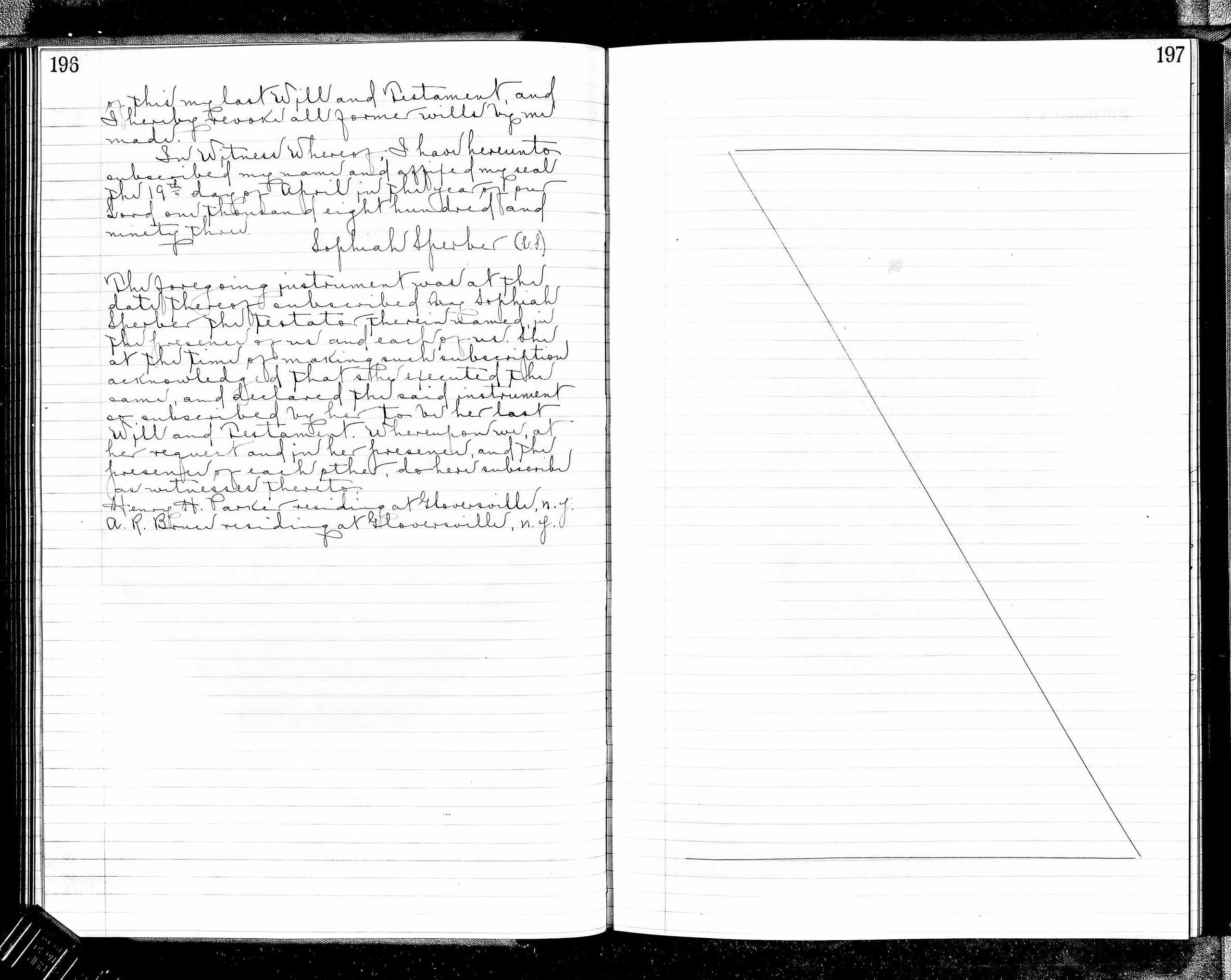
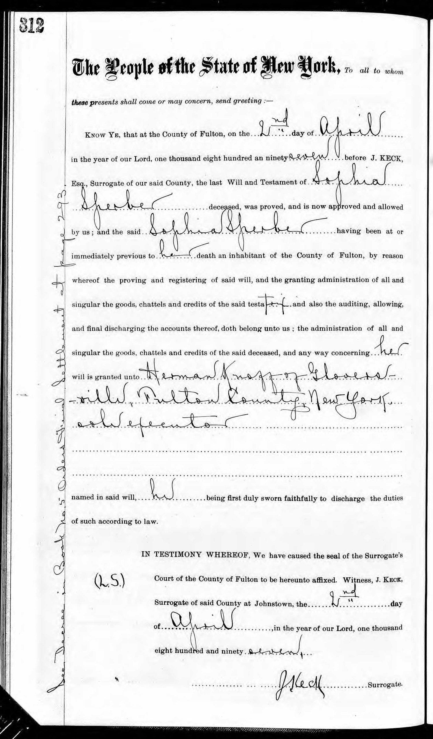
Likewise , I make, constitute and appoint Herman Knoff without bonds to be the executor
Page three of this my last Will and Testament and I hereby revoke all former wills by me made.
In Witness Whereof, I have hereunto subscribed my name and affixed my seal the 19th day of April in the year of our Lord one thousand and eight hundred and ninety three.
The following is a record of the probate hearing on Sophia Sperber’s last will and testament.
Click for Larger View | New York Wills and Probate Records for Sophia Sperber, Fulton County, Letters Test, Vol 0002-0003, 1856 – 1901, Page 312
[26] Documentation on Sophia Sperber’s death:
Click for Larger View | Source: New York Death Index, New York State Department of Health, 1897, Page 759
[27] The following documents Ida Sperber’s marriage on March 25, 1897. While the source does not mention her husband, subsequent evidence in census documents and other records certify that her husband was Charles Griffis.
Click for Larger View | Source: Ida M. Sperber, Marriage certificate 5207, 25 Mar 1897 Gloversville, New York State Department of Health; Albany, NY, USA; New York State Marriage Index, New York State Marriage Index, New York State Department of Health, Albany, NY. Ancestry.com. New York State, Marriage Index, 1881-1967 [database on-line]. Lehi, UT, USA: Ancestry.com Operations, Inc., 2017., 1987, Page 767, Marriage certificate 5207
Ancestry.com. New York State, Marriage Index, 1881-1967 [database on-line]. Lehi, UT, USA: Ancestry.com Operations, Inc., 2017., 1987, Page 767, Marriage certificate 5207


